Earthquakes
S


Evil Rays

Between 500-1,000 reported dead in massive Turkey earthquake

Image
© ReutersA survivor being carried to the ambulance after an earthquake in Tabanli village near the eastern Turkish city of Van October 23, 2011.
Dozens of buildings collapsed in various cities in the southeast region after 6.6-magnitude quake hit.

Turkey's Kandilli Observatory estimates that some 500 to 1,000 people were killed in a powerful earthquake in southeast Turkey's Van province on Sunday, broadcaster CNN Turk reported.

Separately, Deputy Prime Minister Besir Atalay told reporters some 10 buildings had collapsed in Van city and around 25-30 buildings collapsed in the nearby district of Ercis.

The Turkish Red Crescent reported that 25 apartment buildings and one dormitory in the eastern town of Ercis have collapsed. The Red Crescent says its rescuers have pulled several injured people out of the collapsed dormitory

The magnitude 6.6 earthquake hit near Van in southeastern Turkey on Sunday, Turkey's Kandilli Observatory and Research Institute said.
Phoenix

Experts warn a 'rumbling' Icelandic volcano could disrupt air travel, world economy - again

Image
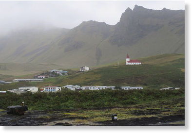
© AP Photo/Paisley DoddsVik, a small Icelandic town of just 300 people, where residents still recall stories from their relatives of Katla volcano's last eruption in 1918, sits under a blanket of cloud in this Sept. 27, 2011 photo. If Iceland's air-traffic paralyzing volcanic eruption in 2011 seemed catastrophic, just wait for the sequel. That's what many experts are saying as they nervously watch rumblings beneath a much more powerful Icelandic volcano - Katla - which could spew an ash cloud dwarfing eruption that cost airlines $2 billion and drove home how vulnerable modern society is to the whims of nature.
Remember when Eyjafjallajökull, that Icelandic volcano with the impossible name, erupted in spring 2010, disrupting air traffic all over the world and costing airlines and the global economy billions?

Child's play, The Associated Press reported over the weekend, if seismic activity from another Icelandic volcano with a history of nasty tantrums leads to an eruption.

Seismologists in Iceland are wary of an increasing number of small, 3- to 4-magnitude earthquakes under the volcano Katla, whose last eruption in 1918 proved deadly.

That eruption produced a noxious cloud that literally blacked out the sun, killing off crops and livestock, the AP reported.

Bizarro Earth

Massive earthquake swarm near Gujarat- Is India on the eve of tearing?

Image
© Wikipedia
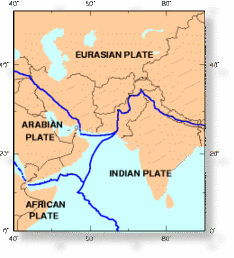
An earthquake swarm of more than 41 earthquakes have shaken the region of Gujarat, India on October 21, 2011 following the 5.0 magnitude earthquake which struck the area the day prior at a depth of 15.5 km (9.6 miles). Since that time, the tremors in the region has increased at a frenzied pace- indicating the earthquake may be more than just a random seismic tremor. The Indian Plate is currently moving northeast at 5 cm/yr (2 in/yr), while the Eurasian Plate is moving north at only 2 cm/yr (0.8 in/yr). This is causing the Eurasian Plate to deform and the India Plate to compress at a rate of about 4 mm/yr (0.15 in/yr).

The compression fold forming the Himalaya Mountains along the Tibetan plateau forms the base-line for the Alpide Belt which, as we mentioned earlier, is showing increased signs of stress. Volcanism and ongoing seismic activity is also being reported in the Karachi region which sits as a buttress between the countries of Pakistan and India. (Above) Encircled areas on the map include major tension points in the country.

Bizarro Earth

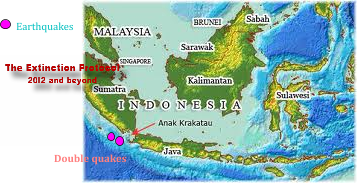
On the brink: Tremors increase at Anak Krakatau to 5,000 a day

Several earthquakes have struck near south Sumatra of the 5.0 and 5.1 magnitude range today- making a tense situation on the volcanically-dotted archipelago potentially even more volatile. The Anak Krakatau volcano is showing signs of increased seismic activity. Authorities fear the volcano is building towards an eruption that could dwarf the one which occurred in 2007.

Image
© Unknown
Indonesia's Volcanology and Geological Disasters Mitigation Center reported the numbers of seismic tremors now registering from the volcano have exceeded 5,000 a day. There are also reports of a gaseous mist which has seeped from the volcano and have enshrouded it in a yellowish haze- something that has never been observed at the volcano before. Anak Krakatau was placed on orange (level 3) status alert on September 30, 2011.

Bizarro Earth

Trio of US Quakes Includes Largest Ever Recorded in Texas

US Quakes
© USGS
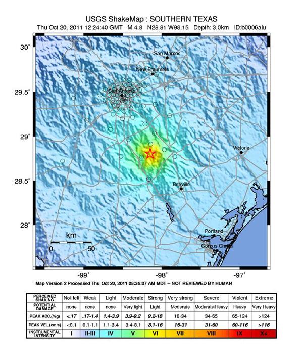
Over the past 48 hours, small earthquakes have rocked various parts of the United States, including the largest ever recorded in Texas by the United States Geological Survey. The quakes, in San Francisco, San Antonio and Hawaii, are unrelated, seismologists said.

No casualties have been reported after the quakes.

"We have lots of earthquakes; it's common, really nothing out of the ordinary. None of the quakes are very big," said Paul Caruso, a geophysicist at the National Earthquake Information Center. "They are totally separate faults and in no way related at all."

A 4.8 magnitude earthquake hit southern Texas, about 47 miles (76 kilometers) outside San Antonio, at 7:24 a.m. local time (8:24 a.m. EDT) yesterday (Oct. 20). The epicenter of the quake was close to Fashing, Texas, a natural gas and oil mining town.

Bizarro Earth

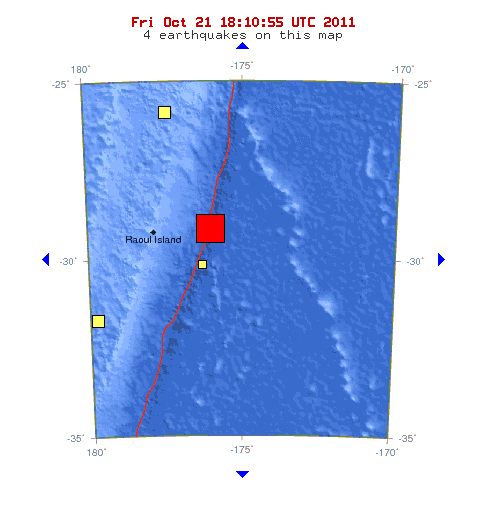
Kermadec Islands Region - Earthquake Magnitude 7.4

Kermadec Quake_211011
© USGSEarthquake Location
Date-Time:
Friday, October 21, 2011 at 17:57:17 UTC

Saturday, October 22, 2011 at 05:57:17 AM at epicenter

Location:
28.941°S, 176.046°W

Depth:
39.8 km (24.7 miles)

Region:
KERMADEC ISLANDS REGION

Distances:
180 km (112 miles) E (79°) from Raoul Island, Kermadec Islands

870 km (541 miles) S (185°) from NUKU'ALOFA, Tonga

2978 km (1851 miles) WSW (240°) from PAPEETE, Tahiti, French Polynesia

Bizarro Earth

Japan: Earthquake Magnitude 6.1 - Hokkaido

Image
© USGS
Date-Time:
Friday, October 21, 2011 at 08:02:37 UTC

Friday, October 21, 2011 at 05:02:37 PM at epicenter

Time of Earthquake in other Time Zones

Location:
43.889°N, 142.477°E

Depth:
185 km (115.0 miles)

Region:
HOKKAIDO, JAPAN REGION

Distances:
17 km (10 miles) NE of Asahikawa, Hokkaido, Japan

121 km (75 miles) NNW of Obihiro, Hokkaido, Japan

131 km (81 miles) NE of Sapporo, Hokkaido, Japan

941 km (584 miles) NNE of TOKYO, Japan

Bizarro Earth

US: California - 4.0 and 3.8 Magnitude Earthquakes Rattle San Francisco Bay Area

Image
© USGSThis map shows the location of Thursday's earthquakes near Berkeley, Calif. (indicated by blue squares) occuring along the Hayward fault zone (red line running underneath).
A pair of earthquakes shook homes and businesses in the San Francisco Bay Area on Thursday.

The first quake, with a magnitude of 4.0 according to the U.S. Geological Survey, struck at 2:41 p.m. local time about 2 miles southeast of Berkeley.

A 3.8 magnitude aftershock centered a mile east of Berkeley followed more than 5 hours later at 8:16 p.m.

USGS officials estimate that more than 4 million residents of the Bay Area felt the quakes, with the worst shaking impacting the East Bay region.

Berkeley and Oakland police both reported no damage, though many in the area took to social media indicating their dishes were rattled.

Bizarro Earth

Northern Italy Rattled by Second Earthquake Swarm in 2 Months

At least ten earthquakes were recorded in northwestern Italy on Thursday, according to the European-Mediterranean Seismological Centre (EMSC).

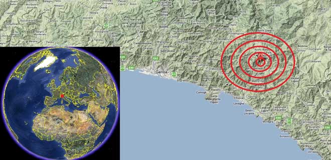
Epicentre of Thursday's earthquake
© Google/IWOEpicentre of Thursday's earthquake.
The largest of the earthquakes measured 4.2 magnitude (mb) on the Richter Scale and occurred at 08:11 AM local time (00:11 AM EDT) at a shallow depth of 10 km. The epicentre was located in the Aveto Natural Regional Park, about 5 km northeast of Borzonasca (pop 2,046), 16 km northeast of Chiavari (pop 27,865), and 39 km east of Genoa (pop 601,951).

It was the strongest earthquake to hit northern Italy since a 4.3 magnitude earthquake struck on 25 July last.

The other nine tremors recorded on Thursday ranged between 2.2 and 3.4 magnitude.

The most significant earthquake to hit the region in recent years occurred on 23 December 2008 when a 5.4 magnitude quake was recorded WNW of Genoa and SW of Parma. Previous to that a 5.4 mb earthquake struck northeast of Verona on 24 November 2004.

Radar

US, California: 3.8 Magnitude Earthquake Jolts San Francisco Area

Image
© USGS
A small earthquake hit the San Francisco area on Thursday afternoon, causing a sharp jolt but no immediate signs of damages or injuries.

The quake, with a preliminary 3.9 magnitude, was centered near Berkeley. San Francisco police and officials at University of California, Berkeley, said they had no reports of injuries or damages.

The U.S. Geological Survey said the earthquake hit two miles (3.2 kilometers) southeast of Berkeley at 2:31 p.m.

The quake was felt as a sharp jolt in the East Bay area, and across the bay in San Francisco.

The quake came almost 22 years to the day after the Loma Prieta earthquake struck the Bay Area during the 1989 World Series.

It came on the same day Californians took part in an annual earthquake preparedness drill at 10:20 a.m. Thursday. More than 8½ million people signed up to participate in the 2011 Great California ShakeOut.