Earthquakes
S


Bizarro Earth

Fiji Region - Earthquake Magnitude 6.0

Fiji Quake_220711
© USGSEarthquake Location
Date-Time:
Friday, July 22, 2011 at 06:56:40 UTC

Friday, July 22, 2011 at 06:56:40 PM at epicenter

Time of Earthquake in other Time Zones

Location:
20.229°S, 178.530°W

Depth:
600.6 km (373.2 miles)

Region
FIJI REGION

Distances:
43 km (26 miles) NNE of Ndoi Island, Fiji

359 km (223 miles) WNW of NUKU'ALOFA, Tonga

400 km (248 miles) SE of SUVA, Viti Levu, Fiji

1949 km (1211 miles) NNE of Auckland, New Zealand

Radar

New Zealand: 5.1 Magnitude Earthquake Hits Christchurch

Christchurch earthquake
© Celsias
An earthquake measuring 5.1 on the Richter scale hit New Zealand's Christchurch city on Friday morning, Xinhua reported.

According to China's Xinhua news agency there were no reports of injuries or damage, following the earthquake that occurred at 5.39 am local time (17.39 GMT on Thursday).

The quake was centred 40 km west of the city, at a depth of 12 km, said New Zealand Institute of Geological and Nuclear Sciences (GNS).

"The earthquake was felt along the east coast of the South Island from North Canterbury to Dunedin" said the GNS duty seismologist Caroline Holden.

Holden further added that a few more magnitude four quakes are expected in the following days.

Target

Earthquake shakes Greek island

zakynthos
Quake-hit: The Greek island of Zakynthos suffered an earthquake of preliminary magnitude 5 - but no one was injured
An earthquake of preliminary magnitude 5 has struck off the Greek island of Zakynthos, but no injuries or damage have been reported, authorities said today.

The Athens Geodynamic Institute said the undersea quake struck at 10.13 a.m. (0713GMT), and had its epicentre about 100 kilometres off the island's south-western coast.

The epicentre was about 350 kilometres west of Athens.

Greece is one of the world's most earthquake-prone countries, and Zakynthos lies in an area of frequent seismic activity. But severe damage and injuries are rare.

Bizarro Earth

Solomon Islands: Earthquake Magnitude 6.0

Solomon Isles Quake_200711
© USGSEarthquake Location
Date-Time:
Wednesday, July 20, 2011 at 22:05:02 UTC

Thursday, July 21, 2011 at 09:05:02 AM at epicenter

Time of Earthquake in other Time Zones

Location:
10.340°S, 162.150°E

Depth:
54.5 km (33.9 miles)

Region
SOLOMON ISLANDS

Distances:
27 km (17 miles) ENE (63°) from Kira Kira, Solomon Islands

238 km (148 miles) SE (138°) from Auki, Solomon Islands

260 km (161 miles) ESE (112°) from HONIARA, Solomon Islands

1640 km (1019 miles) E (95°) from PORT MORESBY, Papua New Guinea

People

Casualties Confirmed After Kyrgyzstan, Uzbekistan Quake

Image
© Google MapEarthquake epicentre.
At least 13 people have been confirmed killed and more than 70 others injured after a strong earthquake struck the southwestern Kyrgyzstan and eastern Uzbekistan border area on early Wednesday morning, officials said.

The 6.2-magnitude earthquake at 1.35 a.m. local time (1935 GMT Tuesday) was centered about 15 kilometres (9.3 miles) east of Okhna, a village in the Batken Province of Kyrgyzstan near the border with Uzbekistan. It struck about 10 kilometres (6.2 miles) deep, making it a shallow earthquake, according to the Kazakhstan National Data Center (KNDC).

The United States Geological Survey (USGS), which measured the strength of the earthquake at 6.1 on the Richter scale, estimated that some 50,000 people may have felt 'very strong' shaking, which could result in moderate to heavy damage. It estimated that some 7.6 million others may have felt moderate to strong shaking.

Ambulance

Thirteen Dead and 86 Injured in Uzbekistan, Kyrgyzstan 6.1 Earthquake

Image
At least 13 people in Uzbekistan have been killed in a 6.1-magnitude earthquake centred in Kyrgyzstan near the two countries' border.

The Uzbek emergency ministry said the quake, in the Ferghana valley, also injured 86 people.

Kyrgyzstan has so far reported no casualties. The quake struck at 0135 on Wednesday (1935 GMT Tuesday).

It was centred 42km (26 miles) south-west of the city of Ferghana at a depth of 18km, the US Geological Survey said.

Bizarro Earth

Uzbekistan: Earthquake Magnitude 6.4

Image
© USGS
A magnitude 6.4 earthquake hit Uzbekistan, the U.S. Geological Survey said on Tuesday.

It said it struck 30 km south-southeast of Ferghana, a city in the east of the Central Asian country. It said the earthquake was 1 km deep.

Bizarro Earth

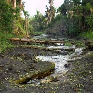
Quake in Costa Rica Causes River to Disappear

Guacalito River disappears
© n/aGuacalito River disappears in Costa Rica after Earthquake
Following a series of moderate earthquakes that struck the country Tuesday, residents around the Guacalito River in Costa Rica discovered that the river had disappeared.

Earthquake-report.com reported that sometime after the earthquakes, villagers living near the river, which is located near Armenia de Upala, discovered that the river was dry.

It was not immediately known if the waters of the river had disappeared due to sinkhole activity that can occur after earthquakes or if the earth shaking caused damming that dried up the river near the Miravalles volcano. The quakes were centered near the Nicaragua and Costa Rica border in the same vicinity as the Miravalles volcano.

An entire body of water disappears? Strange but true, and this isn't the first time this odd event has happened.

In 2010, the Iska River in Slovenia disappeared after local residents heard loud crashing and banging overnight. The next morning, the river was dry and the riverbed was full of fish and other creatures. It was believed that the waters of the river had drained through a large crack into an underground riverbed. This disappearance was not believed to have been related to an earthquake.

Radar

US: Small 3.0 Magnitude Earthquake Rattles North Texas

Image
A small earthquake rattled North Texas Sunday morning, but no major damage was reported.

The quake which had a magnitude of 3.0 was reported at 1:57 a.m.. Sunday about 13 miles west of Waxahachie and 12 miles east, northeast of Cleburne.

An official with the U.S. Geological Survey said Sunday that the quake was at its "most strong" near Venus in Ellis County.

"There might be some cracks in sidewalks and houses may have been shaking a little," said geophysicist Paul Caruso on Sunday. "We don't expect damage from this."

Caruso said that a quake with a magnitude of 5.5 or higher would cause major damages and casualties.

As of Sunday afternoon, the USGS had received 69 reports from residents about the quake in the North Texas area.

Radar

Iceland: Small earthquake swarm in Katla volcano caldera

At the moment there appears to be a small earthquake swarm in Katla volcano. Currently this is just a earthquake swarm. All the tremor plots are normal and show no signs of harmonic tremors and magma on the move. The largest earthquake in this earthquake swarm in inside Katla volcano caldera was a ML1.3 with the depth of 1.7 km according to reviewed data from Icelandic Met Office.
Image
© Icelandic Met Office
The ML1.3 earthquake as I did record it on my Heklubyggð geophone. Given the shape and how low period this earthquake is. I would say that it was created by magma pushing upwards in the crust inside Katla volcano caldera.
Image
© Creative Commons licence
The ML1.3 earthquake as I did record it on my Heklubyggð geophone. Given the shape and how low period this earthquake is. I would say that it was created by magma pushing upwards in the crust inside Katla volcano caldera.