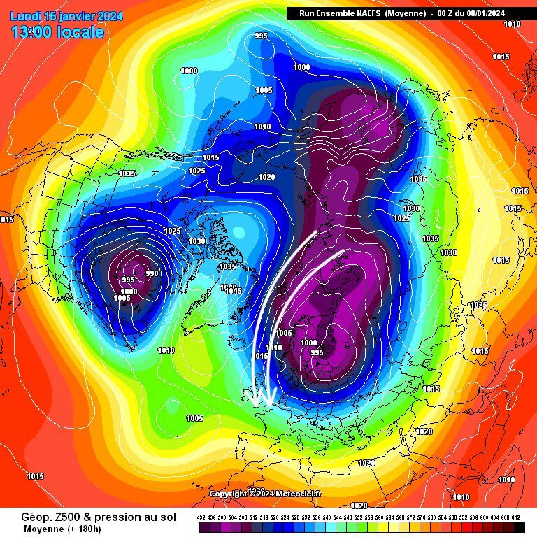
There has been a lot of speculation on social media platform X about the incoming polar vortex.
Weather watchers and meteorologists point out that an ongoing stratospheric warming event could displace the polar vortex from the Pole and pour cold air into the Lower 48.
Comment: Sudden stratospheric warming is the unusual climate variation affecting ozone, heat and wind
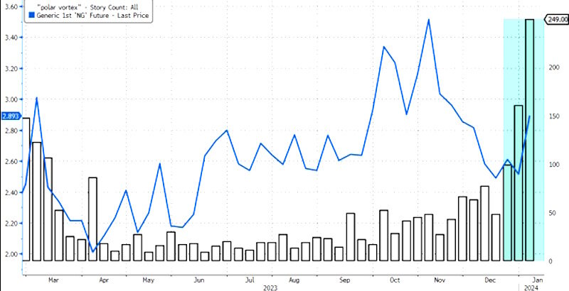
It's not just X users chatting away about a potential polar vortex. Bloomberg data shows headlines across corporate media with "Polar Vortex" have spiked in the last two weeks. We overlaid the headline data with natural gas futures, in which prices are rising, an indication traders could be pricing in a cold snap premium.
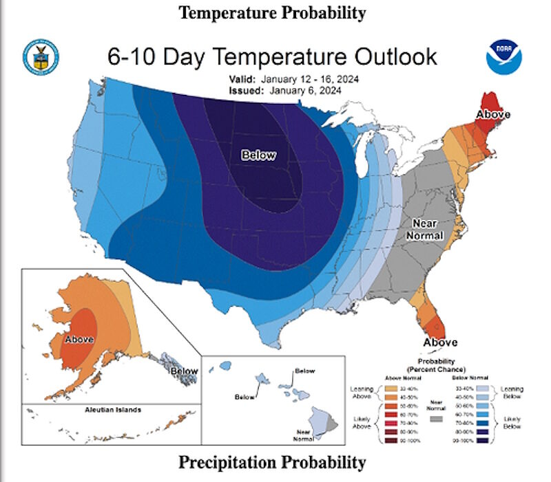
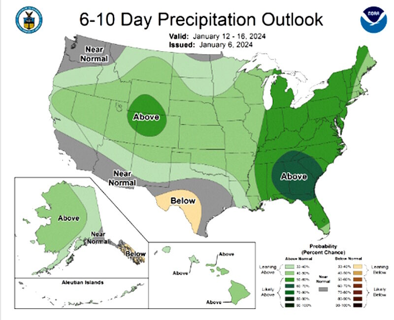
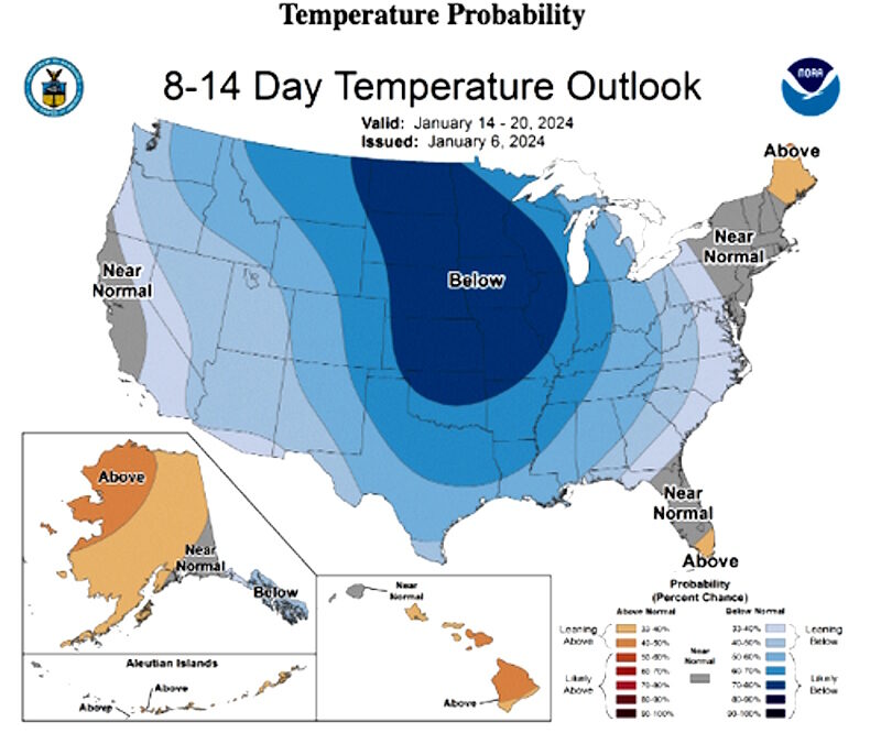
New weather outlooks from the National Weather Service's Climate Prediction Center show a cold blast arriving late next week for Central and Eastern parts of the US.
Couple this with the higher precipitation probabilities — great news for snow lovers.
Longer-term outlooks show more cold is in store after the midpoint of the month.
Sigh.
A new weather note from John Baranik, a meteorologist for DTN, provided more details about the incoming cold blast for the Lower 48:
Those of us in the US and Canada have had short bursts of colder air, but nothing that would be labeled as arctic just yet.Meanwhile, the incoming cold snap reminds us of the multi-billion dollar weather disaster that paralyzed Texas' power grid for over a week in February 2021.
That will all change early next week, as an arm of the polar vortex is pinched off from the North Pole and settles into Western Canada by Jan. 9. Two upper-level ridges, one in Alaska, and another in the North Atlantic, will do the pinching. We have not had a dramatic ridge in either location to start the winter; this is a primary reason why we have yet to see a polar vortex event take place.
But even with the polar vortex starting to develop in Western Canada, it will take another day or two for it to pull down the air from the North Pole, with those arctic-cold anomalies below normal starting to show up on Dec. 10 in northwest Canada.
The cold will expand south and east from there into the U.S. during the following couple of days as the southern jet stream causes a few storm systems to move through the Pacific Northwest and Northern Plains Jan. 10-12. The extent and depth of the cold air are currently in question, as of Jan. 5.
Model forecasts suggest that a ridge in the Southeast may be able to contain that cold air to the western half of the U.S. and Canada, at least the harshest of the cold. That would mean from the Canadian Prairies down to the Texas Panhandle up to Missouri and Minnesota will be the areas east of the Rockies to be put into the icebox for an extended period of time.
Again, models are still working out how cold it might be, and some of that depends on the recent and forecast snow cover. A system that goes through the Plains and Midwest early in the week could lead to some very low temperature readings over the snowpack when the arctic air comes in.
Michael Cembalest, chairman of market and investment strategy for JPMorgan Asset & Wealth Management, recently published a note, reminding clients about power grid instabilities across the US:
Due to to retirement of dispatchable power generation (nuclear, coal, gas) and underinvestment in pipelines, gas storage and winterization, major US cities will face electricity outages and/ or natural gas outages (which are much worse). The North American Electricity Reliability Association just released its 2023 risk assessment. The region NERC highlights as having the greatest risk of power outages, even in normal peak conditions: Midwest MISO, which stretches from Minnesota down to Lo Louisiana. Outage risk in more extreme weather conditions is cited for New York, New England and the entire Western US. NERC cites peak loads rising at " an alarming rate " due to electrification, coinciding with increasingly intermittent new sources of generation ( wind and solar power ) and 80 - 110 GW of nuclear and fossil fuel generation retirements by 2033, which is ~7% of current installed capacity. Reserve margins indicate the buffer each region has to a spike in summer demand; the chart on the left summarizes NERC's assessment of future reserve margins. Note as well how unplanned outages have been rising during cold weather storms.All eyes are on the incoming cold blast and possible grid strain issues due to high heating demand.
If you think power outages are bad, natural gas outages would be far worse. During winter storm Elliott in December 2022, cold weather resulted in the failure of gas production wellheads, pipelines, and distribution. Dry gas production in the lower 48 states fell by 16%, with Marcellus and Utica production falling by 23% - 54%. On December 25, interstate natural gas pipelines serving Con Edison experienced drops in pressure due to production losses and operational issues. Con Ed restored pressure from a backup LNG system until systemwide pressure was normalized, and ended up narrowly avoiding a gas system outage.
During a gas outage, local gas distribution companies would need to go building-by-building and shut off gas valves to ensure that residual gas does not seep through units whose pilot lights are out. During the system restoration process, the main distribution system would be purged; then workers would have to insure at each point of service th at heating and cooking gas lines are safely purged and operational before restoring service and relighting pilot lights. Any homes or buildings with safety issues would need remediation before any gas restoration. Even losing service to 130,000 customers would be considered a major outage and could have taken five to seven weeks (!!) to restore. A large outage could also cause extensive property damage due to burst water pipes within homes and buildingssince water expands when it freezes.
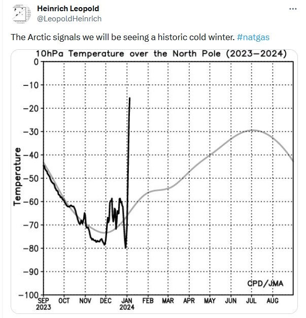


To a technician, such an extremely steep sensor signal looks suspicious. A malfunction, hoax (somebody holding it's hands onto it), or something similiar to that extend ?
Such a rise in a large area would require a HUGE inflow of enery - which had to come from somewhere, and would not go unnoticed.
Something fishy here ...