Dr. Tom Segalstad: "The IPCC global warming model is not supported by the scientific data."
RECORD COLD GRIPS SIBERIA (-68.3F)
Last winter (2020-21) held historically cold across vast swathes of transcontinental Russia — it went down as northern/central Asia's 'longest and harshest' winter on record. But now this year, the chill has started even earlier...
Extreme frosts have struck Siberia this week. A low of -55.7C (-68.3F) was observed in Delyankir on December 1.
Such a reading would be considered rare for January or February, let alone the first morning of December. It's also one just 0.7C and 2.8C above the city's all time November and December low temperature records, respectively.
In addition, Delyankir's high for the day reached only -48.2C (-54.8F) — a new record low-max.
Schools in the region have been cancelled - as is the law whenever temps drop below -50C - which, as noted by mkweather.com, is remarkably early: "frosts below -55C are usually coming only in late-December, January, or early February" ...and this is... "one of the earliest occurrences of frost below -55C in the region in history!"
Elsewhere, Oymyakon reported a minimum temperature of -54.4C (-65.7F) in the early hours of Wednesday morning; Yurty hit -54.3C (-65.7F); and the infamous Verkhoyansk registered -50.1C (-58.2F).
🥶 First -55°C of the season in #Russia 🇷🇺 with -55.7°C in Delyankir.
— Thierry Goose (@ThierryGooseBC) December 2, 2021
Also -54.5°C in Oymyakon and -54.3°C in Yurty.
-50.1°C in Verkhoyansk, first -50°C of the winter.#cold #Siberia @yakutia pic.twitter.com/0zxsKSriuV
As the season progresses, Siberia's early blast of cold is expected to be built upon.
Thanks to the combination of historically low solar activity + a weak NOA, longer-range weather models are foreseeing an intensification of these polar conditions in the coming months. By January, readings below -60C (-76F) are forecast for many regions of Russia (such as Yakutsk) — these would challenge not only all-time regional lows, but also lows for the Northern Hemisphere as a whole.
Stay tuned for updates.
Furthermore, given the current depth of cold and also snow cover across Scandinavia/Siberia, weather models are also suggesting the possibility "of at least a surface high developing" in the coming weeks, writes @Met4CastUK on Twitter (see below). This would increase the chances of further injections of cold/snow into western Europe (including the UK) into December.
Looking at the current depth of cold + snow cover across Scandinavia/Siberia i'm not at all surprised to see models suggesting the possibility of at least a surface high developing.
— Met4CastUK (@Met4CastUK) November 30, 2021
Does this mean the UK goes cold/snowy? No, but it certainly increases that possibility into Dec. pic.twitter.com/O4PMG6PrSv
NORTHERN HEMISPHERE SNOW MASS MARCHES ON
Snow mass across the entire Northern Hemisphere is progressing incredibly well this season, and currently stands at more than 250 Gigatons above the 1982-2012 average - an impossibility under the original global warming theory:
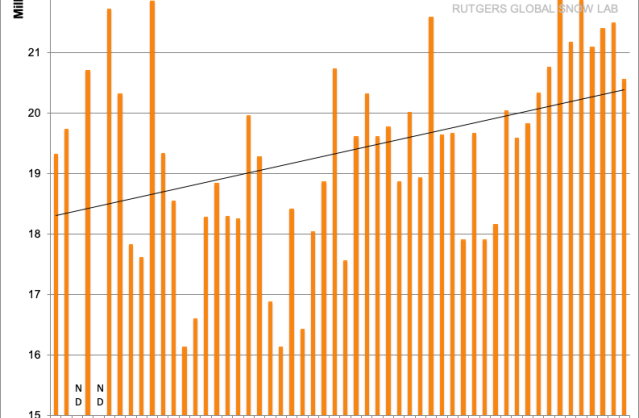
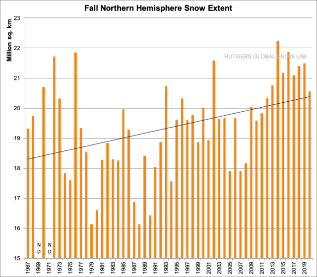
Note also that the NH's multidecadal trend is one of increasing snow cover, particularly in the fall:
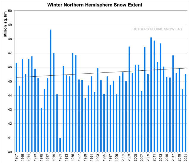
But also in the winter, too:
CANADA SUFFERED LOWEST NOVEMBER TEMP SINCE 2004 (-45.6F)
Trends appear to have shifted in the Arctic.
This summer/fall, sea ice has been holding/building strong, with extent on course to be the highest since 2001:
This shift is also seen in Greenland, where data from the Danish Meteorological Institute (DMI) reveals that the ice loss trend across the glacier has now reversed:
Increased ice cover in the Arctic will often translate to colder temperatures further south, as descending polar air masses have a larger area of ice to traverse on their way down to the lower latitudes — i.e., they hold colder for longer.
Siberia and Europe, as discussed above, have been cases in point of late, and while much of North America is currently residing on 'the other side' of the jet stream - meaning the U.S. is experiencing above average temps - it is a different story up in Canada.
Due to a weak and wavy meridional jet stream flow, North America's 'winter freeze' is currently confined to the northernmost latitudes. Because of this 'concentration', the cold up there has been quite extreme.
In Canada's northernmost weather research base, Eureka, a low of -43.1C (-45.6F) was registered on November 28 (with a windchill of -59C (-74.2F) — this was the base's coldest November temperature since 2004's -43.3C (-45.9F), and before that you have to go back to 1989's
The warmer conditions currently prevailing down south - in the U.S. - can be looked at as Earth's climate system working to find some equilibrium. More specifically, a 'buckling' jet stream - linked to the historically low solar activity we're experiencing - has pulled tropical warmth up into the CONUS and is preventing polar cold from spilling down — the JS is effectively keeping Arctic air locked in the northern latitudes, and as a result, temperatures up there have been intense (hence Eureka's -43.1C).
Looking ahead though, this setup is set to shift as we enter the second week of December.
The U.S. is about to find itself 'above' a violently descending jet stream, meaning it will be open to frigid Arctic air. This will represent a stark 'swing between extremes', which is another symptom of low solar activity.
(Read more here)


Reader Comments
I've been called a few choice things for going against the corruption and misinformation so deliberately broadcast by the media but I have been loyal to my own observations and beliefs.
Humanity is about to face atmospheric conditions that our infrastructures are ill prepared to deal with and no amount of spin by the those guilty of spreading lies will save their faces.
An Ice Age is knocking on our door, the sooner we adapt to this reality the better.
[Link]
[Link]
[Link]
Sleeping AID (skip to 5min mark)
[Link]
California?
Cold air is presently 10 degrees North of California and there's an active jetstream on its Southern boundary which is pulling in warmer moisture ladened air in off the North Pacific ocean.
This flow of air will maintain seasonal temperatures in California but not for long.
There's a blob of cold air showing up at 700hpa just of shore and a similar blob of cold air inland to the west.
Now these "blobs" are relatively new features ( past 6 years) in earth's upper atmosphere, they develop in front of a cold air mass before being absorbed by it, they are ineffect an indicator of how far cold air will travel.
There's also swathes of cold air that rotate around the Northern hemisphere, typically the Northern states and the Western seaboard of the US are effected by these movements of cold air.
The cold air mass has continued to build in the Northern hemisphere, allowing these swathes of cold air to travel further south towards the equator.
Extended arms of cold air reach beyond these swathes and such an extension has just crippled Hawii with snowfall.
Given the fact that Autumn has just begun it is reasonable enough to forecast a continuation of this migration of cold air and California is next in its sights.
So LM, dig deep into to your wardrobe and have some warm woolies at the ready.
Wow and yes I saw that Hawaii.
I'm used to digging and yup to the woolies and getting prepared for years for our upcoming new reality
Nothing like getting things done before the shit starts flying.
Baybars, lsjarvi ++ say hello
Expect colder conditions to be heading Californias way soon 🥶
My partner 🥰 and I 🤗 are throughly enjoying the stormy events here in the UK, we're having a 4 day jolly 🥳 🥳 🥳 at a remote seaside location and enjoying everything Mother Nature can throw at us.
Its been Cold, wet and incredibly windy but magical aswell.
We've just got all our hiking boots etc dried from battling today's storm, mind we had a few beers too 🥳 🍺 🥳 🍺 🥳 and met some lovely people.
Tomorrow where in Whitby, being more sensible.
Gorgeous🐧🐧
You know what they say about the winds eh Spirit sails on them.
I had a gf from Whitby 🥳 are you from Whitby?
I spent quite some time up in Dumfries eons ago it seems, almost like a past life😔
Cali can freeze over lolll
I'm up in Val D'OR ... getting my ass kicked around real hard in the last month 😡 but I hold tight to the windee sails lolllll and kickbox back 💃⚽️🥅🎯 MFers!!
I love rustic remote seaside locations, where like minded people gather, those who love fresh air, walking , local history and enjoy local produce.
Our trip to Whitby today was very enjoyable and we returned to our base in Robin Hoods Bay, a quintessential remote, historic seaside location.
Sorry to hear that your derriere is in the firing line but hope things will improve
Derrière is a powerhouse lollll
Wonderful!! 1 cup daily and IT IS essential we all go back to sleeping solo for abit lolll
5 cups daily of CHAGA Tea is the other Key to add for BALANCED Nature in our gorgeous bods.
ORGANS are given to be organ-ized! Happy Organs = PH Balance🤺
For anyone with trouble sleeping + one extra bonus from Dr Allen Mandell, he is HotHot as is Dr Sten Ekberg and Dr Berg.
[Link]
[Link]
[Link]
[Link]
[Link]