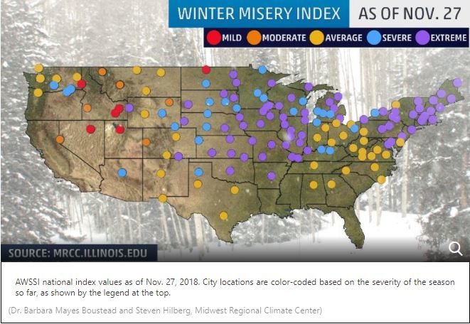
According to the Accumulated Winter Season Severity Index (AWSSI) from the Midwest Regional Climate Center, 74 cities from New England to the Plains and Rockies have seen an extreme season-to-date of cold and snow as of Nov. 27.
This index takes into account the "intensity and persistence of cold weather, the frequency and amount of snow and the amount and persistence of snow on the ground," the Midwest Regional Climate Center says. Wind and mixed precipitation, such as freezing rain, are not a part of the index.
The index uses five categories - mild, moderate, average, severe and extreme - to rate the severity of winter weather in cities across the U.S.
For any given location, the start date of the winter season is defined as when the first measurable snowfall (at least 0.1 inches) occurs or when the first high temperature of 32 degrees or lower is recorded. The start date is Dec. 1 for any location that does not see either of those happen before that date.
"The spread among the categories is very narrow this early in the season," said Dr. Barbara Mayes Boustead, a co-creator of the index and an instructor at the National Weather Service's Warning Decision Training Division in Norman, Oklahoma.
Cities categorized as having an extreme winter, so far, ranked in the 99th percentile of the index for Nov. 27.
A combination of persistent cold from the Northeast to the Plains and a pair of expansive winter storms, Avery and then Bruce, gave this winter season a fast start.
Five of those extreme cities in the Northeast had a record extreme start to winter:
- Berlin, New Hampshire: This northern New Hampshire town crushed its previous record-to-date index by picking up 18.6 inches of snow - more than six times its average snow-to-date of only 2.9 inches - and logging six days in which highs did not rise above freezing.
- Burlington, Vermont: Burlington picked up almost triple its average season-to-date snowfall and had seven days during which temperatures did not rise above freezing.
- Caribou, Maine: This town in northern Maine already picked up roughly one-quarter of its average seasonal snow even before winter officially arrived. Snow from Winter Storm Bruce was still falling as of publication. Add 11 days which the daytime high didn't rise above freezing, and you can see why the index is at a season-to-date record.
- Jackman, Maine: Similar to Berlin, Jackman's 14 days of freezing or colder high temperatures and more than double its average season-to-date snowfall - almost 20 inches, as of Nov. 26 - put it on a record early-season pace.
- New York City: This is primarily due to Winter Storm Avery dumping Central Park's second heaviest November calendar-day snow on record - 6.4 inches - as well as a pair of days that failed to rise above freezing: Thanksgiving and Black Friday.

It was the third coldest November-to-date through the 26th in both Kansas City and Little Rock, according to the Southeast Regional Climate Center.
Winter Storm Bruce pushed Chicago's O'Hare Airport to its snowiest start to a season in records dating to 1958. It has already received 12 inches of snow. In an average year, it takes until the second week of January for O'Hare to receive that amount.
Typical cold spots such as Duluth, Minnesota; Fargo North Dakota; and Marquette, Michigan, were also in the extreme 99th percentile through late November due to persistent cold, despite the former two locations pacing a tad under average snowfall.
Just over another two dozen cities were categorized as having a severe winter-to-date, the next category below extreme on the misery scale. Among these cities are Buffalo, New York; Louisville, Kentucky; Minneapolis; Pierre, South Dakota; and Flagstaff, Arizona.
As to whether this winter index is predictive for the rest of winter, think of trying to decipher the NFL season after week 1 or 2.
"We can't judge much about the upcoming winter season based on the early-season AWSSI," Mayes Boustead said. "It isn't until maybe January that we can start to get a feel for the character of the winter.
"That said, it's certainly striking to see a lot of cold and snowy early-season winter conditions across a wide swath of the country."
Slow Start in Parts of the West
On the flip side, parts of the West have gotten off to a slow start to the winter season, remaining either rather mild or snowless so far. This is particularly the case in Alaska.
- Anchorage: Less snowy than Amarillo, Texas, Anchorage Ted Stevens International Airport measured only 2.7 inches of snow through Nov. 26. It's among their top 10 least snowy starts to a season through that date. November was also pacing among the top 10 warmest on record.
- Salt Lake City: It finally picked up its first snow of the season on Nov. 24. The 1.7 inches of snow so far this season is less than one-quarter of the average-to-date snowfall. The city also has yet to record a day below freezing.


Comment: Snowmageddon: 6,000 flights grounded or delayed in US as Thanksgiving storm rages on