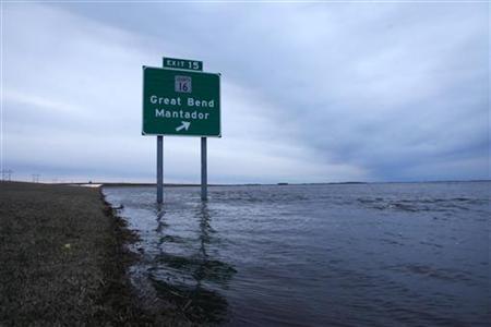
The Red River reached a preliminary crest at 49.87 feet on Thursday at Grand Forks and continues to spread out across regions north of the city, reaching eight miles wide or more at Oslo, Minnesota, which has become an island amid the swells, the National Weather Service said on Friday.
The Red River forms the North Dakota-Minnesota border, flowing north into Canada. A tributary system stretching from southern Canada and South Dakota feeds into the main Red River as it reaches toward Lake Winnipeg in Manitoba.
"We will be dealing with flood issues throughout April and well into May," said Greg Gust, a U.S. National Weather Service warning coordination meteorologist. "It will be a long time before we push the last of the flood waters across the Canadian border."
At just under 50 feet, the Red River crest at Grand Forks was the third highest on record and three of four bridges are expected to stay closed at least well into next week.
"Water is still pretty high through town here, things still blocked off and buttoned up," Gust said.
Grand Forks and neighboring East Grand Forks, Minnesota, have permanent flood barriers that have protected them from the near-record crest, leaving the focus on communities nearby.
North of Grand Forks, Interstate 29 that runs parallel along the Red River in North Dakota was closed for 24 miles. The interstate was just opened north of Fargo in recent days.
Complicating efforts on Friday, storms dropped up to 8 inches of snow in the area west of Fargo and lesser amounts in Fargo and northwest Minnesota, the weather service said.
North Dakota farm officials said Friday they were concerned that the snowstorm could create conditions similar to those that killed tens of thousands of cattle in other flood years.
Major overland flooding west and north of Fargo is expected into late April as water released from dams on tributaries makes its way slowly to the Red River.
The U.S. Army Corps of Engineers on Friday said it would add to temporary levees at two North Dakota cities west of Fargo, Valley City and Lisbon, and backup levees where needed to increase water releases from a dam upstream.
By Monday, the weather service is expecting the Sheyenne River to reach a record crest at Valley City above 20.7 feet as increased flows from the Baldhill Dam reach the area.
"The water that is breaking out over land is diminishing somewhat, but it will re-fill in," Gust said. "The rural areas just to the west and north of Fargo, that is going to be heavily impacted for quite a while."
Fargo itself could come close to 2009 levels when the Red River stayed above major flood stage for 32 days and flood stage for 60 days, Gust said.
This year's expansive flooding also was expected to have a major impact on the amount of land North Dakota farmers will be able to plant this spring.


Reader Comments
to our Newsletter