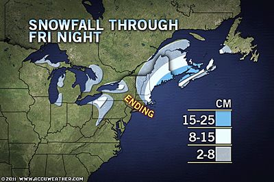
The heaviest snow will stretch from southeastern Maine through Prince Edward Island, southeastern New Brunswick and northwestern Nova Scotia, where 15 to 25 centimeters of snow will fall from the storm.
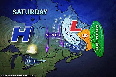
A mix with or a change to rain will limit accumulations in southeastern Nova Scotia and Newfoundland.
Like many storms that visit the region, the system is strengthening. As a result, winds will kick up and can gust past 80 kph tonight, raising seas and leading to blowing snow.
As winds crank up, warmer air will rush in south and east of the storm track, but colder air will pour in on the heels of the storm. As a result, a few hours of blizzard conditions are likely over the Bay of Fundy and Northumberland Strait regions. This includes the cities of Saint John, Moncton, Fredericton, Amherst and Charlottetown.
In areas that get a change to a wintry mix or even rain, slush will freeze in the wake of the storm this weekend.
For much of southern Ontario, Quebec and the Maritimes, the air rolling in from the Arctic into the weekend will bring the coldest weather of the winter so far.
Even though much of Newfoundland is likely to have a change to rain with this first storm, a second storm Sunday afternoon and night will bring a much colder scenario thanks to the invading air from the west.
That Sunday storm could be an all-out blizzard for much of Newfoundland with potential for 80-kph winds and blinding, heavy snow in many areas, especially west of St. John's. This storm is forecast to bypass most of Nova Scotia to the south and east.
A third winter storm may hit all of Atlantic Canada during the second half of next week.


Reader Comments
to our Newsletter