© Associated Press
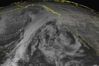
Record rainfall in the Pacific Northwest triggered mudslides and threatened to cause severe flooding of some Western Washington rivers Sunday.
Although the rain had eased in much of southwest Washington and northwest Oregon, including Portland, downpours continued from Seattle north, swelling rivers and threatening some small towns. The rain was expected to lessen Sunday evening, with the worst of the flood danger over by early Monday.
Still, flood watches or warnings remained in effect for the region, and forecasters said storms could dump 6 inches or more of rain in the Cascade Range and Olympic Mountains.
"We're looking at the wettest storm system we've had for in almost two years," said National Weather Service meteorologist Kirby Cook in Seattle.
Crews reopened U.S. Highway 2 near Skykomish after a mudslide blocked it early Sunday. That same slide, on the west slope of the Cascades about 47 miles east of Seattle, also blocked the railroad track across the Cascades from Everett to Wenatchee, but crews hoped to have that open Sunday afternoon, Burlington Northern Santa Fe spokesman Gus Melonas said.
BNSF crews were working to clear numerous other mud and rock slides throughout Western Washington, and Amtrak service was suspended in the region until Tuesday morning as a precaution, Melonas said. No trains have been hit by slides and freight trains continue to run, he said.
Slides blocked at least one street in Seattle and closed State Route 11, the scenic Chuckanut Drive, south of Bellingham. A small slide also blocked a train track just north of the tunnel that runs under downtown Seattle, but it was cleared in about a half hour.
The weather service warned of severe and possibly near-record flooding in rural areas on the North and South Forks of the Stillaguamish River northeast of Everett. Parts of Washington's Nooksack, Skykomish, Chehalis, Snohomish, Tolt and Snoqualmie rivers also were expected to reach flood stage.
Seattle-Tacoma International Airport set a rainfall record for the date of 1.42 inches, breaking the old mark for Dec. 11 of 1.32 inches set in 1955. Quillayute on the Pacific Coast also had a record for the date, 2.17 inches. The old record was 1.64 inches, set in 2002.
The weather service said the rain was not expected to threaten the heavily developed Green River Valley south of Seattle. Flooding has been a worry since heavy rain in January 2009 damaged a reservoir wall at Howard Hanson Dam upstream.
Cook described the storm system as a "plume of very moist, warm Pacific air." Its relative warmth brought rain, not snow into the Cascades, causing large runoff from the mountains, feeding and overwhelming rivers and creeks on the lowlands.
National Weather Service meteorologist Dave Elson in Portland said coastal Oregon rivers and tributaries of the Willamette River could rise out of their banks, but said the flood threat wasn't as severe as in Washington.
Portland city officials said an overnight break from the rain allowed most flooded intersections to drain.

Reader Comments
to our Newsletter