Please take a moment to read that story above as I can't post it here. Associated Press has declared war on bloggers.
First a few caveats:
- Yes (as mentioned about the northeast USA beach water temperatures in the AP article) we have some very warm sea surface temperatures this summer, we also had the coolest summer surface temperatures on record in many places in the USA.
- The AP story is written by Seth Borenstein. Seth tends to report the warmest side of things in the worst way, so take the story with a grain of salt. For example, Portland Maine also set a new record low for July Temperatures, see here. I don't think Seth covered that one nor the -50°F all time statewide Maine record low on January 16th, 2009 seen here. One should also note that NOAA reported "July Temperature Below-Average for the U.S." How quickly we forget. I'm not trying to pick a weather -vs- climate food fight, but simply pointing this out for balance. We've had some cold events this year also.
- Sea temperature spikes like this have have happened before. More on that later.
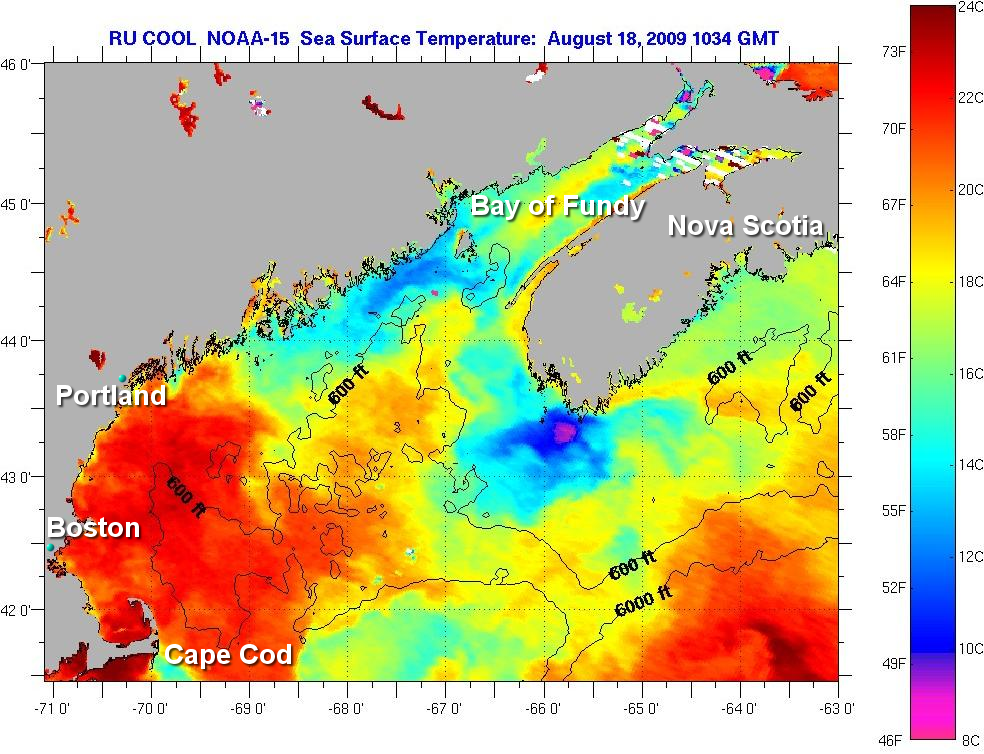
To check that out, I utilized the Rutgers SST satellite page here. This image showing coastal Maine from NOAA-15 on August 18th seemed fairly representative and was one of the few that was almost completely filled with SST data. As you can see on this summary page, there is a lot of missing data. With this much missing data, one wonders if SST data averages are accurate.
I've annotated the image to give you landmarks and cities. Our warmer buddy "Tamino" lives in Portland, I wonder if he's taking a dip. As you can see, indeed there is some 72 degree water around Portland. But up in the Bay of Fundy and tip of Nova Scotia, there's some pretty cold water also, and it is in the 45 to 55 degree range.
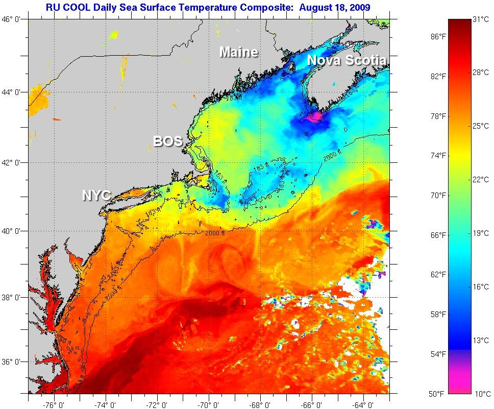
A wider view SST of the northeastern US shows the reason for this juxtaposing of opposite ends of the sensing range:
I've also annotated this image to give you landmarks and cities.
Note the prominent tongue of warm water and the eddies and swirls. That is the warm water of the Gulf Stream mixing with the cold water of the north. In the middle mix, pleasant swimming temperatures. The earth is doing what is has always done, transporting warm water northward via the Gulf Stream. Yes it is a little stronger this year and maybe a little closer to the coast than usual.
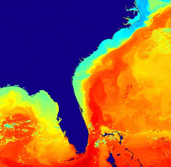
Here's a view of the source in the Gulf of Mexico, Oh...wait...I had to use a different source since the NOAA/Rutgers imagery was missing so much data in the Gulf - see for yourself here.
This Weather Underground plot of buoy based sea temperature measurements shows that indeed the Gulf is warm and around the 90 degrees indicated in the article.
But the question is: is this warmth an event to be concerned about? From the Rutgers map above, it appears that the Gulf Stream has come closer to shore than it normally does, which of course makes it more noticeable to people recreating in the water.This of course generates attention, and reporters naturally pick up on these things. The question is: weather or climate?
Here's a NOAA Ocean Explorer SST image from a 2005 article that shows how the Gulf Stream tends to hang off the coast a bit more.
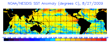
And of course, we have an El Nino going on, so a warmer Pacific is certainly not unexpected.
Note the the temperatures above are anomalies, not absolute measurements.
As the AP article mentions, the last time we saw ocean temperature this high was in 1998 during the super El Nino.
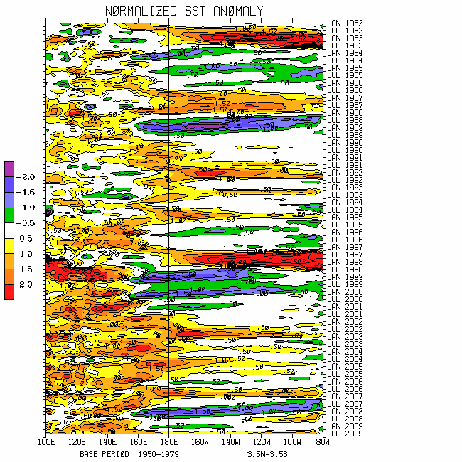
What I find most interesting though is this NOAA Hovmoller graph as pointed out by Paul Vaughn in Bob Tisdale's thread:
Hovmollering the SST: T-shirt tie-dye design or climate science?
Just looking at the 1982-1983 and 1997-1998 SST spikes, it does seem like we are due for another at the bottom doesn't it?
The point I'm making here. Yes the ocean is warm, it has gotten warm before. Should we panic? No.
A couple of closing points. The AP article that I referenced at the beginning of this post makes no references as to sources other than generally mentioning NCDC.
However I did find a more in depth NPR/AP article that did reference the NCDC sources which you can read here.
The two sources listed were:
(Link)
(Link)
But there is no mention of this on either source:
"The average water temperature worldwide was 62.6 degrees, according to the National Climatic Data Center"The latest summary NCDC offers ( which AP referenced: [Link] ) is for July 2009 where they say this:
The global ocean surface temperature for July 2009 was the warmest on record, 0.59°C (1.06°F) above the 20th century average of 16.4°C (61.5°F). This broke the previous July record set in 1998. The July ocean surface temperature departure from the long-term average equals June 2009 value, which was also a record.So that makes me wonder, did NCDC give Seth Borenstein some inside information for the middle of August that the rest of us aren't privy to? Or, could it be a misprint or C to F conversion error?
I simply don't know, but I do find it odd that I can't find a NOAA or NCDC press release or data table that has that 62.6 degrees mentioned in it. If anyone knows where that figure came from, please post it in comments. Google is saturated with so many news stories with the keyword combination of NCDC and 62.6 that I'm unable to locate the original source. That doesn't mean it doesn't exist, but if it does, I'm sure our WUWT readers will find it.


Reader Comments
to our Newsletter