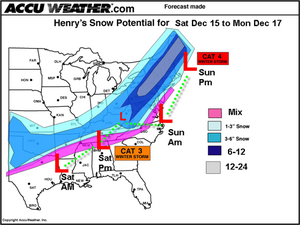
And that's just the kinda guy he is. Nobody else has scootched that far out on the limb yet. But Hank says he couldn't resist.
The National Weather Service is still hedging its bets. The computer models still don't agree, and there are just too many variables to say where the storm will go, and who will get what sort of precipitation. The discussion today suggests a more southerly track would bring us snow, but other models have the storm on a more northerly trajectory, leaving us with rain and mixed precipitation. The official forecast says only "snow likely" on Saturday night, then "chance of snow or rain" on Sunday.
The one thing that does seem to be coming into focus is the fact that a significant "nor'easter" could be brewing. And nor'easters are the kind of storm that has brought Baltimore its deepest and most disruptive winter snow events. There is also talk of this storm scooping up moisture from sub-tropical storm Olga, now pummeling Hispaniola.
Anyway, Henry's map will surely have to be revised as the days slip by, but here it is anyway, just for fun. The "Cat.3" and "Cat.4" stuff, BTW, refers to the Northeast Snowfall Impact Scale. Here's more on that.

|
| ©Accuweather |


Reader Comments
to our Newsletter