Millions of people along the coasts of Myanmar (Burma), Bangladesh, and India may be at risk of suffering a catastrophic tsunami-generating earthquake, according to a new study.
The northern Bay of Bengal could be pummeled by a temblor as massive as the one that sent devastating tsunamis into Indonesia and other Indian Ocean countries in December 2004, the research suggests.

|
| ©the SeaWiFS Project, NASA/Goddard Space Flight Center, and ORBIMAGE
|
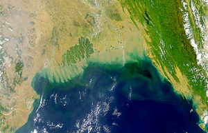
A satellite image shows the northern Bay of Bengal.
A new study suggests that millions in the area - which includes parts of Myanmar (Burma), Bangladesh, and India - face the threat of a massive earthquake and tsunami that could even rival the events of the December 26, 2004, Indian Ocean tsunami.
|
Previous research had raised little concern about potential earthquakes in the northern part of the bay, which lies between India and the Malay Peninsula.
But Phil Cummins, a senior seismologist at Geoscience Australia in Canberra, evaluated historical accounts of seismic events, including records of a major quake in the region in 1762.
When combined with recent observations of stress accumulation in the region, the data suggest that a magnitude 8.8 earthquake could occur within 200 years.
Cummins presents his results in tomorrow's issue of the journal
Nature.
Outside experts said the findings should be taken seriously and should spur further studies of the quake and tsunami potential in the area - home to more than 60 million people. (Get tsunami facts.)
Historical ThreatEarthquakes generally occur along plate boundaries - places where pieces of Earth's crust slide past each other in fits and starts.
The location of the plate boundary in the northern Bay of Bengal is not well understood, according to experts who work in the region.
Current maps of the tectonic plates in the bay show the boundary following a trench that extends northward from India's Andaman Islands and through Myanmar (see a map of the region).
But historical accounts of the 1762 earthquake come from the southern and northern extremes of Myanmar's Arakan coast, along the northwestern edge of the country where it borders Bangladesh.
This suggests that the earthquake ruptured for about 435 miles (700 kilometers) along Myanmar's coast, according to Cummins.
"If you look at existing tectonic maps, that just shouldn't happen," he said.
Cummins reexamined the evidence for the plate boundary and concluded it was unclear.
"What was clear though - and became even more clear with recent GPS [global positioning system] results in that area - is that there is active deformation to the west of the plate boundary that appears on tectonic maps," he said.
"And that is consistent with an earthquake occurring there."
Cummins also noted historical changes in coastal land levels from the quake, with uplift in the south and sinking in the north, indicating a slip of 33 feet (10 meters). That's consistent with the type of rupture that occurs on an offshore thrust fault - the kind that generates tsunamis.
The historical accounts also suggest that the 1762 quake created a local tsunami in the southern area of the Arakan coast. Whether a giant wave also occurred in the northern area is less clear, Cummins noted, but "the potential is there."
When Cummins ran this data through a computer simulation, he determined that the 1762 quake had a magnitude of 8.8 centered off the Arakan coast. The December 26, 2004, earthquake is estimated to have been about magnitude 9.0.
Cummins concludes in Nature "that giant earthquakes probably occur off the coast of Myanmar, and that a large and vulnerable population is thereby exposed to a significant earthquake and tsunami hazard."
Deadly RiskAvailable GPS measurements suggest stress is now accumulating in the Bay of Bengal at 0.9 inch (23 millimeters) a year. At that rate, a quake similar to the 1762 event may not occur for 200 years.
But the fault may not rupture in a single massive earthquake. A smaller earthquake could occur sooner and still send out deadly tsunamis, Cummins noted.
He hopes other researchers will attempt to confirm his hypothesis with further geological evidence as well as more detailed investigations of land deformation in the bay.
John McCloskey is a seismologist at the University of Ulster in Northern Ireland who has studied the potential for large earthquakes in Sumatra.
He said Cummins' arguments for a major tsunami-generating earthquake "vary in strength."
Several assumptions about the complex geology of the region and the historical accounts must combine to produce the worst-case scenario presented, he noted.
"The probabilities associated with something like that become less and less quantifiable the more of these assumptions we have to take on board," McCloskey said.
However, he added, "anything we can do to try and make people think about the threat to the 60 million or so coastal population in this area is welcome."
Roger Bilham is a geophysicist who studies earthquake hazards at the University of Colorado at Boulder. He said everything in the study is "scientifically credible" and that the research offers a view of the maximum earthquake threat in the region.
The only unknowns, he noted, are how frequently these earthquakes occur and how the stress is accumulating in the region.
"I think it's a warning that you've got to expect something," Bilham said.
Reader Comments
to our Newsletter