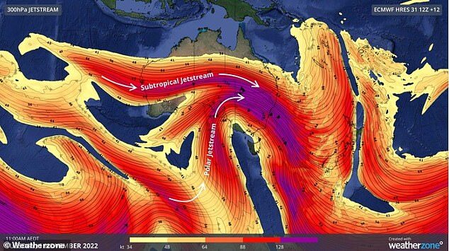
The cold Antarctic air has been dragged north by a pend in the polar jetstream - a band of wind that continuously flows about 8 to 15km above sea level.
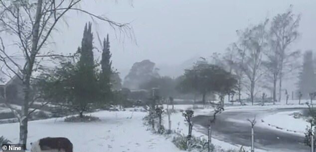
Icy gusts are lashing the east coast and snow is dumping just outside of Sydney and in south-eastern alpine region as the polar jetstream clashes with the separate subtropical jetstream.
It comes as residents of Melbourne and Canberra experience temperatures in the single digits - with the nation's capital hitting just six degrees on Wednesday morning and Melbourne nine degrees, with the mercury set to rise throughout the day.
Inland parts of NSW have also experienced widespread showers and scattered thunderstorms.
The state's central west is expected to bear the brunt of conditions with snow possible above 800 metres around Lithgow, Orange and Bathurst and more rain will flood already swollen creeks and catchments.
Lighter snowfall will extend further west, while many areas in NSW will have a maximum temperature 10 to 15 below normal.
NSW Minister for Regional Transport and Roads Sam Farraway warned motorists in the region to take care with wet and icy roads.
'The recent extreme weather has badly damaged roads right across the state's network and the forecast of more rain and possible snow only adds to our concerns,' he said.
'The potential for snow and black ice on roads across the Central West will create additional road hazards.
'Some areas across the state's west have received no rainfall for days but we are not yet seeing floodwaters recede.'
A dangerous mix of weather was created by the two jet streams clashing over the country due to the contrast in air mass density and temperature.
The polar stream is bringing cold air from the Antarctic while the subtropical sends through warmer air.

Flood warnings are also in place across regions in east and south-east Australia as the wild weather produces heavy rain.
Major flooding is expected at Coonamble and Nanami in NSW on Wednesday, and on Friday at Forbes which copped a deluge last month. The Bureau of Meteorology also expects major flooding on the Bogan River.
More than 90 SES hazard warnings are current for NSW with 48 flood rescues carried out and nearly 760 requests for assistance.
Evacuation orders are in place for residents in Moama, Mathoura, Cowra and Tumut.
Weatherzone meteorologist Yoska Hernandez told Daily Mail Australia that conditions should ease in the coming days.
'The worst of the weather should be today and tomorrow with damaging winds, snowfall and showers.'
'The high pressure system will settle the weather over the following days in the south-east.'
She added that the jet stream was already moving past the east towards the Tasman Sea.


I've been called " alarmist " on a few occasions by some less knowledge kinds here on SOTT, but what I've posted, has and is coming true.
The Southern parts of Australia midst as well forget their Summer of 2022 and by 2023 the Northern parts of Australia too.
I cannot emphasis enough the trend that's now taken a grip of Earth's atmosphere/ weather and both poles with now begin to lay down ice at an unprecedented level.
I might rename myself Seer WN3