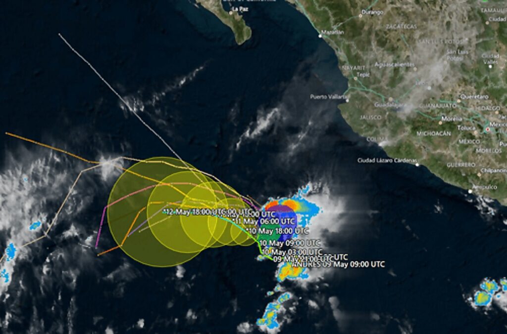
Andres formed off the southwest coast of Mexico Sunday, had sustained winds of 40 mph and moved out to sea at six mph.
"Increasing southwesterly to westerly shear and drier air to the west of the cyclone should prevent any significant additional strengthening," the National Hurricane Center said Sunday.
Meteorologist Phil Klotzbach from Colorado State University said, "Andres is the earliest calendar year eastern tropical Pacific (to 140°W) named storm formation on record, breaking the old record of May 10 set by Adrian in 2017."
The official start of the eastern Pacific hurricane season is May 15. The Pacific is not the only ocean basin expected to observe increasing tropical activity this year. Another above-average Atlantic hurricane season is expected. The season starts on June 1.
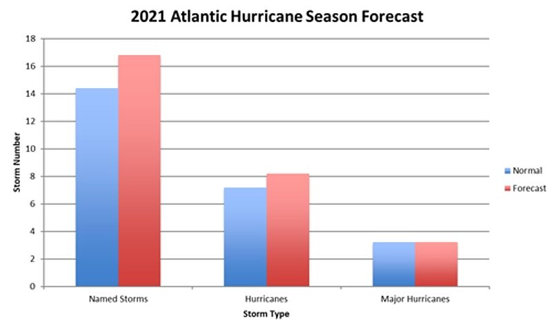
Klotzbach expects there will be 17 named storms in the Atlantic - eight becoming hurricanes.
Refinitiv's commodity desk provides a more in-depth view of the 2021 hurricane season, only to say it will be the 6th consecutive season of above-normal tropical activity in the Atlantic:
- The 2020 Atlantic hurricane season ended up being hyperactive, with significant impacts on oil operations in the Gulf of Mexico as well as devastation in Nicaragua
- 2021 is likely to fall into the "near normal" category in terms of tropical activity, though there is upside risk toward an active season
- Impacts from landfalling hurricanes could shift eastward this season toward the U.S. East Coast and the Leeward Islands based on Atlantic SSTs
Unlike last season, the 2021 outlook does not include a hyperactive season within the expected range of outcomes, though there is very little chance for below normal activity this season. Upside toward an active season does exist if key forecast drivers consolidate in that direction, and above normal tropical activity is anticipated based on all metrics except for major hurricanes this season. It should be noted that a "normal hurricane season" now represents higher levels of tropical activity in all aspects because of the climatology update that uses 1991-2020 as the baseline instead of 1981-2010. For example, if our 2021 outlook was issued based on the previous climatology, our forecast would call for an active season instead of a near normal one. Related to the climatology change (increased storm number), the Greek alphabet will no longer be used to extend the name list moving forward, replaced by a secondary name list if the initial one is exhausted. Details behind our 2021 outlook are outlined below:
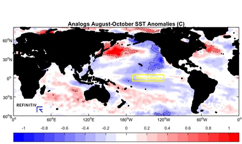
- Forecast Indicators: At a two-month lead time from the start of the 2021 Atlantic hurricane season (begins 01 June), and a four-month lead on the beginning of the peak season where ~90% of the total activity occurs, the major ocean basins are aligned in support of a near to above normal season of tropical activity once again. Beginning with ENSO (El Niño Southern Oscillation), there is an 80% chance of neutral or La Niña conditions being in place by the August-October peak of hurricane season, with only a 20% chance of El Nio. La Niña is the most favorable state for active Atlantic seasons as it supports low vertical wind shear needed for tropical cyclone intensification/formation, so the strong likelihood of neutral or La Niña conditions in 2021 supports an active year while the slight El Niño chance caps the potential to some degree. The Atlantic Multi-decadal Oscillation (AMO) shows an 80% chance to be in its favorable warm SST phase for Atlantic tropical activity. The largest question pertains to the Indian Ocean Dipole (IOD), which has a connection to Atlantic activity in relation the occurrence of dry air that suppresses tropical cyclone formation. In 2021, there are questions about the state of the IOD by August-October, which supports a nearer to normal hurricane season.
- 2021 Hurricane Season Outlook: Based on the forecast indicators outlined, analog years were selected to help produce a forecast for 2021 Atlantic tropical cyclone activity. The most reliable variable forecasted is accumulated cyclone energy (ACE), which is widely viewed as the best measure of cyclone activity as compared to total named storm number, hurricane number, etc. The reason for this is that tropical cyclones vary wildly in duration/lifetime (anywhere from 1-10+ days), so similar numbers of storms in different years can still represent very different levels of activity. We also represent the forecast in terms of average/expected numbers of tropical storms, hurricanes, and major hurricanes, which is what is presented in the forecast summary of Figure 1. Our forecast for the June-November hurricane season is for activity to be at 107% of normal. The spread among the analogs was relatively narrow, with 20% of the years showing below normal activity while the other 80% showed above normal activity (see Figure 2). Due to the narrow range among analog years relative to the new normal level of activity, 100% of the analog years used in the forecast fell into the "near normal" range (within 25% of normal). This results in a high confidence outlook for near to above normal activity in 2021, with the direction of ENSO and the IOD key issues to watch in the direction that the season takes.
Separate from overall Atlantic hurricane activity, impacts on commodities such as oil and shipping depend on storms reaching the Gulf of Mexico and/or making landfall in North America. The analog years used in the forecast and current SST anomalies both depict the U.S. East Coast as being at the greatest risk for higher impacts than usual based on warm ocean waters off the coastline. If the picture holds, any developing tropical cyclone that moves across the Western Atlantic approaching the U.S. will have ample energy to tap into and become a high-impact hurricane if other environmental conditions allow. There is also a consensus for slightly warmer than normal SSTs around the Leeward Islands of the Caribbean Sea, making that another area to watch for high-end impacts this season. Gulf of Mexico SSTs are by no means cold but are nowhere near the record warmth of last year.
2020 verification and summary
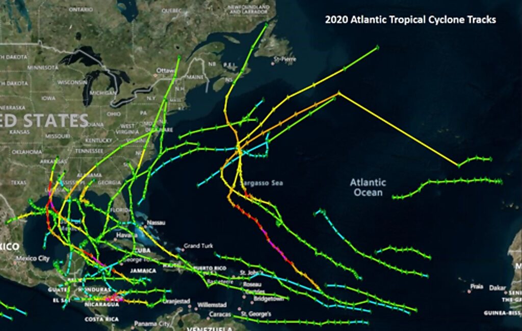
The 2020 Atlantic hurricane season finished with 30 named storms, 13 hurricanes, and 6 major hurricanes. Total tropical activity came in at 176% of normal, as measured by accumulated cyclone energy (ACE). This hyperactive season made 2020 the 5th consecutive active season in the Atlantic, demonstrating the highest degree of tropical Atlantic activity since 2017. Our 2020 Atlantic tropical seasonal outlook called for an active season with a risk toward hyperactive levels, which means that the hyperactive season observed was within our anticipated range of outcomes albeit on the top end of the range.
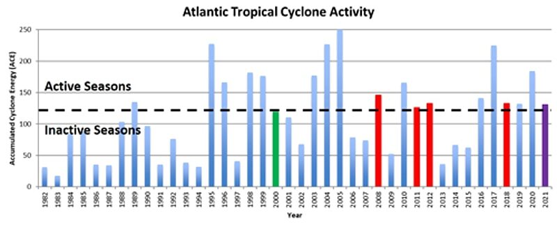
- Impacts: The 2020 Atlantic Hurricane season was a worst-case scenario in terms of impacts based on activity being strongly focused over the Gulf of Mexico and Central America (Figure 4). A flurry of storms made landfall in the Gulf of Mexico, with eastern Texans and Louisiana being the hardest-hit U.S. areas from two major hurricanes impacting the region. This activity caused major disruptions for oil operations in the Gulf of Mexico. Nicaragua also experienced landfalls by major hurricanes in close succession, which resulted in catastrophic damage to the coastal areas of the country. Meanwhile, the U.S. East Coast and the Caribbean Leeward Islands dodged major impacts in 2020 as generally quieter areas.


Reader Comments
to our Newsletter