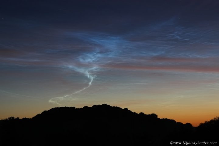
"It was amazing to watch," he says. "This area then morphed into an succession of dynamic shapes-a wedge, a funnel, angel wings, an electrified smoke ring, then a long rope tornado which reached towards the horizon."
What creates these forms? The answer is "gravity waves."
Gravity waves are, essentially, waves of pressure and temperature spawned by powerful storm systems. Gravity does not vary inside the waves; they get their name from the fact that gravity acts as a restoring force that tries to restore equilibrium to up-and-down moving air. Gravity waves can propagate all the way from Earth's surface up to the mesosphere, where they imprint themselves on the the forms of noctilucent clouds. When a sufficient number of gravity waves meet, they can interfere to produce all of the structures McKenna saw-plus many more.
Summer is the season for NLCs. Summertime wisps of water vapor rise to the top of Earth's atmosphere where they wrap themselves around specks of meteor smoke. Mesospheric winds gather the resulting ice crystals into noctilucent clouds.
Comment: Spaceweather.com also reports:
MYSTERIOUS TWINNED RAINBOWFor more on our increasingly changing skies:
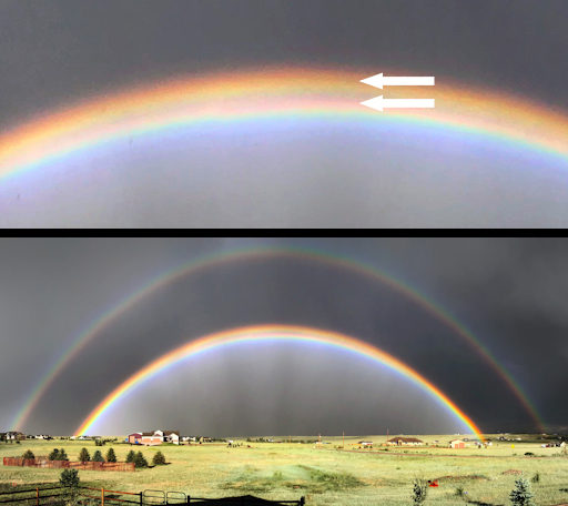
Scientists have been studying rainbows for hundreds of years, since the 17th century when Isaac Newton first explained the colorful arcs. Yet after all these years, there is one rainbow scientists do not fully understand--the "twinned bow." Jan Curtis photographed this specimen on June 21st from Cheyenne, Wyoming:
"This rare 'twinned rainbow' was perhaps the brightest rainbow I've ever seen," says Curtis. "It followed on the tails of a extremely severe thunderstorm that fortunately passed just a few miles to my north."
"Several twinned bows have been imaged, mostly during heavy showers, but currently there is no agreed explanation for them," says atmospheric optics expert Les Cowley. "They might form from a mixture of water drops and ice spheres." Indeed, Curtis reports intense hail around the time of his sighting.
"A stronger possibility is that non-spherical raindrops produce one or both bows," Cowley adds. "Surface tension forces keep small raindrops fiercely spherical but as they fall large drops are flattened by air resistance or might even oscillate between flattened and elongated spheroids."
Another striking aspect of Curtis's image is the overall double structure of the rainbow--one rainbow on the inside, another on the outside. Such double rainbows are often seen and well understood. The splitting of the inner bow into twins added a dash of mystery to this otherwise common occurance.
MIDNIGHT RAINBOW
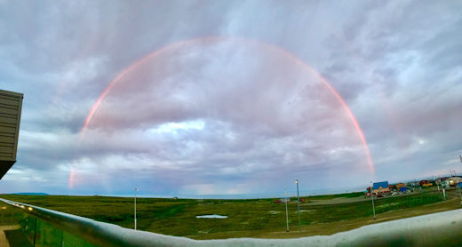
A rainbow at midnight? Believe it. On June 25th, red rays from the midnight sun in Nome, Alaska, lanced into a bank of rain clouds, producing this strange red arc:
"The rainbow developed, then disappeared and reappeared, slowly growing into a full arc around 1:30am here in Alaska," says photographer John Dean.
At the time, the sun was hugging the horizon, barely half a degree high. This explains why the rainbow was red. Normal rainbows are red, yellow, green and blue. In this case, however, red was the only color available. All of the other colors had been scattered away by air molecules and dust particles in front of the low-hanging sun.
Red rainbows are more common than you might think. They appear with frequency at sunrise or sunset, all around the world.
Realtime Space Weather Photo Gallery
NIGHT-SHINING CLOUDS VS. AURORAS
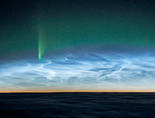
The cockpit of an airplane can be a good place to see space weather in action. "On June 20th I witnessed a rare coincidence of two space weather apparitions!" reports pilot Ulrich C. Beinert. "I was flying from Los Angeles to Munich, passing over Canada, when a rippling band of noctilucent clouds (NLCs) appeared. Soon they were joined by Northern Lights."
Beinert's photo captures an unusual meeting of green auroras and electric-blue NLCs. The auroras were caused by solar wind gently buffeting Earth's magnetic field, sparking a verdant glow 100 to 200 km above Earth's surface. Noctilucent clouds are completely different. They are formed when summertime wisps of water vapor rise to the top of the atmosphere and crystallize around specks of meteor smoke. NLCs float about 80 km high, just below the aurora zone.
Because summer is the season for NLCs, it is the only time they can meet auroras in sub-Arctic skies. "It was amazing to see them together," says Beinert.
NOCTILUCENT CLOUDS FROM ABOVE & BELOW
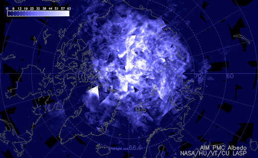
For the 4th week in a row, NASA's AIM spacecraft has observed an increase in noctilucent clouds (NLCs) above the Arctic Circle. This is the latest image showing our planet's north pole capped in electric-blue:
AIM is in a polar orbit ~500 km above Earth's surface--the perfect location to see noctilucent clouds. Data from the spacecraft show electric-blue tendrils spilling over the Arctic Circle into Canada and especially Europe.
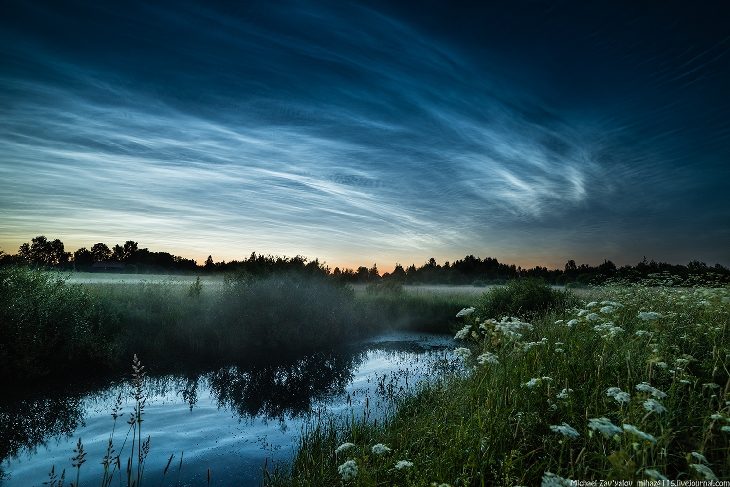
As AIM monitors the clouds from above, people are starting to see them from below as well. Last night, Michael Zavyalov took this picture from Vyatskoe, a village in the Yaroslavl region of Russia:
"The silvery clouds were uniquely vivid," says Zavyalov. "They glowed in the night sky long after sunset with waves and ripples unlike any other clouds I have seen."
NLCs are our planet's highest clouds. They form when summertime wisps of water vapor rise to the top of Earth's atmosphere and crystalize around specks of meteor smoke. Rippling mesospheric winds gather the resulting ice crystals into swarms floating ~80 km above the ground.
When noctilucent clouds first appeared in the 19th century, you had to travel to the Arctic to see them. In recent years, however, NLCs have intensified and spread with summer sightings as far south as Utah and Colorado. Observing tips: Look west 30 to 60 minutes after sunset when the sun has dipped well below the horizon. If you see luminous blue-white tendrils spreading across the sky, you may have spotted a noctilucent cloud.

Reader Comments
to our Newsletter