While not setting records, a few other unusual and notable weather occurrences have caught our eye this month.
1) California's Northern Sierra Nevada Set Record For All-Time Wettest 'Water Year'
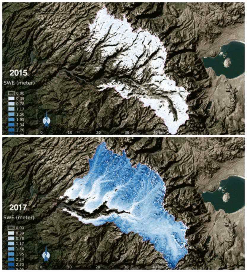
On April 13, California's northern Sierra Nevada set a new record for its all-time wettest water year with an accumulated average of 89.7 inches of water. The previous record of 88.5 inches was set during the 1982-83 water year. To put it in perspective, the average water year sees 50 inches of precipitation.
The water year runs from October through September, but most precipitation falls from November through March. By April, the storm track typically shifts reducing the chance for additional precipitation. This year, however, has been different with rain and mountain snow continuing to fall this month, allowing records to topple.
This wet pattern has also brought an incredible amount of snow. The snow pack in northern California usually peaks on April 1, but it has continued to grow this year through mid-April. The Sugar Bowl Resort in the northern Sierra Nevada has measured 782 inches of snow for the 2016-17 season, which is well above the average of 500 inches.
In addition, the central Sierra Nevada is very close to setting a new record for wettest water year on record. Through April 17, the central Sierra Nevada is in third place with 69.5 inches, which is just half an inch below second place. The wettest water year on record is 1982-83 which saw 77.4 inches of precipitation.
2) New Record Number of Days With Measurable Precipitation in Seattle
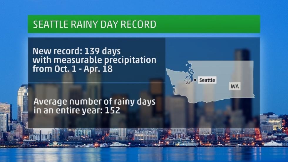
The Pacific Northwest has experienced above-average precipitation. On April 18, Seattle set a new record for days with measurable precipitation, with 139 days since Oct. 1, the start of the water year. The previous record was 137 days set in 2010-11 and in 1998-99.
This record number of rainy days has resulted in a gloomy pattern in the Emerald City and leading many to become frustrated with the lack of sunshine.
This wet pattern has brought 43.71 inches of precipitation to Seattle from Oct. 1-April 18, significantly above the average of 29.96 inches. The wettest water year on record was just last year when 49.17 inches was measured. Given that the water year runs through September, this year's total will likely rise, potentially topping the record.
3) Record-Setting Amount of Snow on the Ground in Caribou, Maine
Caribou had a foot or more of snow on the ground every day from Nov. 30 to April 10 - 132 consecutive days, which set a new record. The previous record was 120 days set in 1968-69.
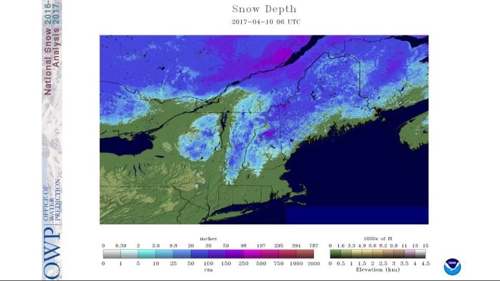
The cold temperatures experienced in March, along with heavy snow from Winter Storm Stella, helped push Caribou to this record. There was actually more snow on the ground at the end of March compared to the beginning of the month.
Overall, snowfall this season has been above average, with 122.1 inches of snow accumulating through April 18, which is 15.5 inches more than usual season-to-date.
4) Drought Relief In Some Areas
Last fall, drought conditions increased across parts of the South and Northeast and persisted in the West. However, a pattern change this winter resulted in the drought being eliminated in most of the West.
A wetter pattern has also brought some much-needed improvement to portions of the South and Northeast. Some areas in the Plains have also seen a reduction in drought conditions.
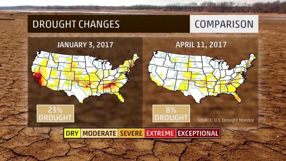
There are no areas in the U.S. experiencing exceptional drought, the highest category and only 0.09 percent of the U.S. is in extreme drought, the second highest category. The area where extreme drought persists is in portions of northern Georgia and far northwestern South Carolina.
But the news has not been good for all areas. Portions of central and southern Florida have seen drought areas increase, which has contributed to the wildfire situation in the region.
5) Severe Weather Impacts South, Including Mile-Wide Tornado in Texas
On the evening of April 14, a long-lived supercell thunderstorm in the Texas panhandle produced multiple tornadoes. One of these tornadoes occurred near Dimmitt, Texas, and was a mile wide and rated an EF3.
This incredibly long-lasting and slow-moving thunderstorm impacted areas from just east of Clovis, New Mexico to the Dimmitt area for several hours.
The main tornado was estimated to have peak winds of 140 mph and destroyed a building and damaged nearby homes. This thunderstorm also brought large hail that shattered windshields of at least two cars.
April began with two severe weather outbreaks that impacted the South. Between the two outbreaks, more than 90 tornadoes were confirmed. This includes an EF2 tornado that traveled 15 miles through Randolph, Steward and Webster counties in Georgia and a second EF2 that tracked 20 miles in Laurens and Treutlen counties in Georgia on April 5.
On April 6, two tornadoes were confirmed in Washington D.C., including one that crossed over the National Mall.
6) Wildfires Have Burned More Than Four Times the Average So Far This Year
The drought conditions mentioned previously has helped to set the stage for wildfires. Warmer-than-average temperatures, in combination with the dry conditions and gusty winds at times, have produced an environment conducive to fire development.
Through mid-April U.S. wildfires have burned more than four times the average this year, with more than 16,000 fires burning more than 2 million acres through April 14, according to the National Interagency Fire Center. This is significantly above the average from 2006-2015 of 515,661 acres.
Recently, Florida has been the hot spot for active wildfires where fires have burned more acres since January than are typically burned in a year, based on a five-year average.
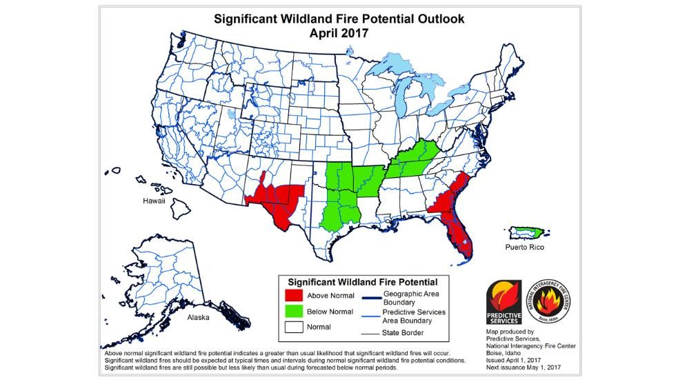
The map above highlights in red areas that are expected to have a greater than normal risk of wildfire potential through April. In the Southeast this includes Florida, as well as parts of Georgia and South Carolina. A second area of concern is portions of southern New Mexico and western Texas.
7) Unusual Temperature Changes
Much of the eastern and southern U.S. saw a winter with temperatures much warmer than average. This changed in March when much-cooler temperatures were experienced in the Northeast.
However, yet another flip has occurred and conditions have been significantly warmer than average for much of the East so far in April. Areas of snow have melted for locations east of the Mississippi, with the exception of far northern New England.
Due to this overall warm trend, warm temperature records have been set at an amazing ratio of 5-to-1 compared to cold records so far this year.
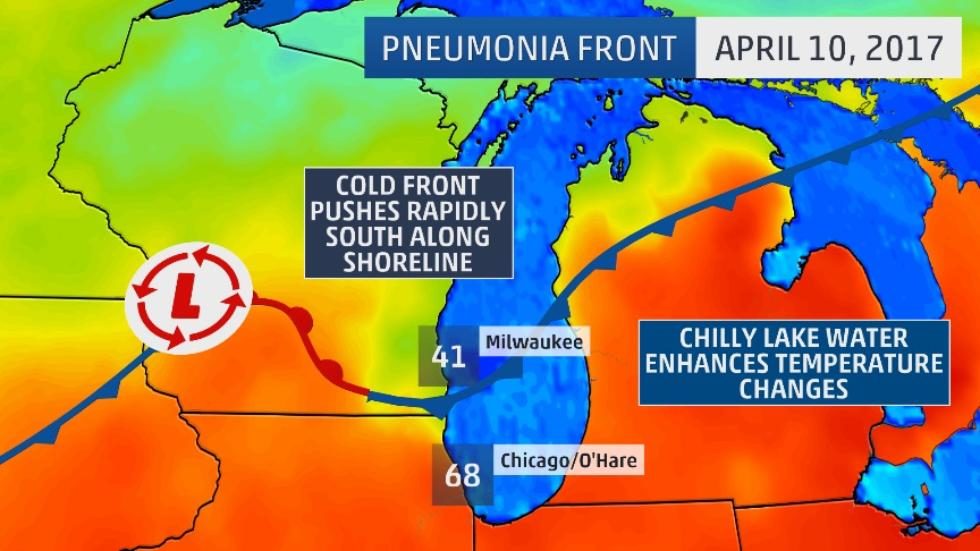
However, as spring is a season of sometimes rapid temperature changes, there have been some interesting local temperature occurrences this April. On April 10, a pneumonia front brought a temperature plunge of 30 degrees in an hour in Milwaukee. Temperatures also dropped 22 degrees in an hour in Waukegan, Illinois, north of Chicago.
On the other side of the spectrum, a heat burst resulted in an impressive 17-degree temperature spike in an hour near Childress, Texas early April 17.
A heat burst is a potential byproduct of a dying thunderstorm. When there is not enough precipitation falling or the air is too dry, the precipitation evaporates above the surface and consequently, the air falls quickly and warms by compression. The result is a blast of hot, dry wind reaching the ground.
When this takes place at night, the resulting temperature rise can be impressive, as it pushes through a typical shallow layer of cooler air near the surface. This was the case in Childress between 3 and 4 a.m. when the temperature jumped from 64 degrees to 81 degrees.


Comment: According to NOAA's Storm Prediction Center (SPC) there have been 5,372 preliminary reports of severe weather across the United States in 2017 (up to April 8), which is more than double the average.
For more coverage on the extreme weather affecting the entire planet, check out our monthly SOTT Earth Changes Summaries. Last month:
SOTT Earth Changes Summary - March 2017: Extreme Weather, Planetary Upheaval, Meteor Fireballs