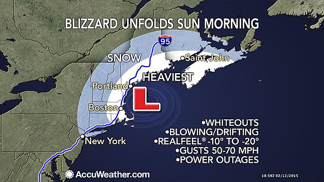
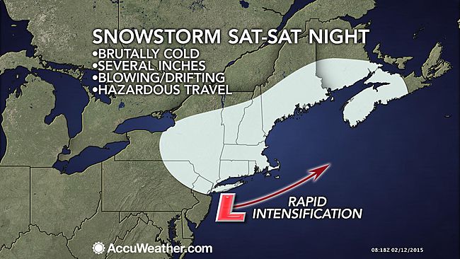
A storm moving through the Northeast during the Valentine's Day weekend will develop into a blizzard with snow, fierce wind and bitterly cold air.
While
the first of two clipper storms this week will stay weak until swinging east of New England, the second clipper storm rolling in this weekend will strengthen significantly.
People on weekend ski trips or partaking in other travel from the Great Lakes to New England will run the risk of getting stuck in the storm
and the frigid air moving in.
According to AccuWeather.com Senior Meteorologist Henry Margusity, "The storm could bring life-threatening conditions, especially in New England with very low temperatures and strong winds combining with snow to bring blizzard conditions."
Initially, light snow will move across the Midwest Friday night into Saturday. However, winds will increase after the snow begins as bitterly cold arctic air arrives and AccuWeather RealFeel® Temperatures plunge below zero F.
The snow and increasing wind will move into the central Appalachians during the day Saturday and will reach the Interstate-95 corridor in the mid-Atlantic and southern New England Saturday afternoon and evening.
As the storm reaches the Atlantic Ocean Saturday night, it will strengthen.
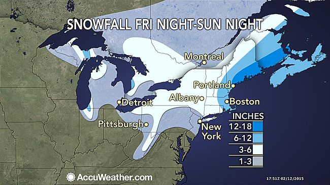
The storm has the potential to bring a moderate to heavy snowfall from the upper part of the mid-Atlantic to southern and central New England Saturday night into Sunday.
Officials and people with travel plans from New York City to Boston and Albany, New York, should monitor the progress of this storm and prepare for disruptions to daily activities.
Lesser snow or a couple of snow showers will occur farther south in the mid-Atlantic.
AccuWeather.com will continue to provide updates on the storm and expected snowfall through this weekend.
Even where a small amount of snow falls, there will be extensive blowing and drifting of the snow on the ground as the storm progresses and in its wake.
Roads may get snow covered and very slippery in some areas. The frigid air moving in will render most inexpensive ice-melting compounds ineffective. Areas of slush and standing water will freeze.
Strong winds in the absence of heavy snow can be enough to cause significant airline delays. Gusts topping 45 mph are possible from Chicago and Detroit to Cleveland, Pittsburgh, New York City, Philadelphia, Baltimore and Washington, D.C.
According to AccuWeather.com Meteorologist Mark Mancuso, "Bands of intense lake-effect snow will develop close behind the storm, especially downwind of lakes Michigan, Huron and Ontario."
Travel could be difficult and dangerous along portions of the I-80/90 corridor in Pennsylvania, New York state, New Jersey and the Midwest due to areas of snow, strong crosswinds and bitterly cold air.
Whiteout conditions are possible in parts of northern Indiana, Michigan, southwestern Ontario and upstate New York.
Some lake-effect snow will also occur off Lake Erie even though this shallow water body is mostly frozen over.


Reader Comments
to our Newsletter