Severe storms moved across parts of eastern South Dakota Monday closing roads, flooding streets, highways and fields, and increasing flows in the Big Sioux River.
Daugaard on Tuesday met with emergency management officials in Elk Point and later toured flood-affected areas in Minnehaha and Lincoln counties.
The National Weather Service in Sioux Falls said rainfall amounts Monday afternoon and overnight were greater than 2.5 inches in most areas, with some reaching more than 4 inches.
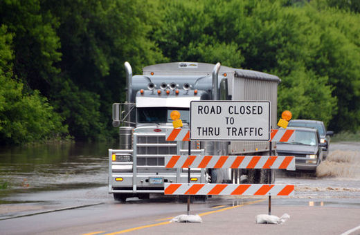
U.S. Highway 18 at the South Dakota-Iowa border east of Canton remained closed Tuesday, but larger trucks and SUVs were moving through the water despite the signs warning against it.
A tractor trailer and two smaller trucks work their way through standing water on a closed portion of U.S. Highway 18 at the South Dakota-Iowa border, Tuesday, June 17, 2014, east of Canton, S.D. Severe storms moved across parts of eastern South Dakota Monday closing roads, flooding streets, highways and fields and increasing flows in the Big Sioux River. (AP Photo/Dirk Lammers)
Flood waters washed out some railroad track just east of the Eastern Farmers Cooperative in Canton. The weather service said 8.4 inches came down in the area during the storm.
In Sioux Falls, officials said the water treatment plant handled more than 57 million gallons on Monday when an average day involves no more than 16 million gallons. Officials reported street flooding, downed trees and power outages following the storm.
Golf enthusiasts in nearby Brandon will have to wait a few days before they can tee off at the Brandon Golf Course. Managers said 90 percent of the course is underwater.
The U.S. Army Corps of Engineers Northwestern Division on Tuesday announced it is reducing releases from Gavins Point Dam in Yankton in an effort to reduce the flood risk downstream.
"Gavins Point Dam releases will be reduced from 30,000 cubic feet per second to 12,000 (cubic feet per second) in response to increased tributary flows," Jody Farhat, chief of the Missouri River Water Management Division, said in a statement.
Farhat said releases were reduced by 4,000 cubic feet per second Sunday and by 10,000 cubic feet per second Tuesday. An additional 4,000 cubic feet per second reduction is scheduled for Wednesday.
Associated Press


Reader Comments
to our Newsletter