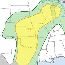
It's been kind of quiet for May thus far in the Plains. Typically, this is the peak of both tornadoes in any given year, and it is also the peak for the Oklahoma and Kansas portion of Tornado Alley. Quiet days, and spreading wildfires aside, things have turned progressively more active lately, and today into tomorrow could end up making up for "lost time" last week.
We've been out in the Plains for the better part of the last 10+ days, after leaving the D.C. area for a two-week storm chasing excursion late in the evening of April 30. For the most part, the first week was pretty quiet after we intercepted a few severe storms in Arkansas and Tennessee on May 1. Five thousand miles later (with many more to go), we've seen some action, but have also been eagerly awaiting today.
On the storm front, our luck began to shift by last Friday, as a strong dry line started forming in Plains while a large upper-level low pressure trough dug through the West Coast. Rather than hang out in Texas, where storms were isolated, we decided to go looking for the highest tornado threat, which oddly enough were Nebraska and South Dakota on Sunday and Monday, typically areas that experience tornadoes later in the season.
On Sunday, we ended up partly with a "blue sky bust," though we redeemed the day a bit by racing into South Dakota to pick up some severe storms there including one for which a tornado warning had been previously issue.
The Monday chase threatened to be another blue sky bust (as Discovery's Reed Timmer tweeted from the area during the day), but ultimately proved fruitful thanks to much patient waiting. We very closely tracked a tornadic storm through its life cycle. Unfortunately, it also came largely after sunset, and we did not see the tornado ourselves even though we were right next to it.
Back to today -- most severe weather and tornado outbreaks in the southern Plains come when a long wave trough (thousands of miles rather than a small disturbance) pushes through the Rockies and breaks out into a warm and humid air mass over the region. This is more or less the scenario for today.
It's not a "perfect" setup - long-term drought in the region, in addition to potential energy-sapping morning activity, slightly weaker turning with height than some larger events, and a possible isolated to scattered nature of storms, could all be issues for the many storm watchers crowding into the area. Still, it's about as good as I could hope for while out here if I want to see a tornado.
Regarding the overall setup, The Storm Prediction Center says:
...SEVERE WEATHER EPISODE WILL BE LIKELY ACROSS THE SRN AND CNTRL PLAINS TODAY WITH AN ISOLATED THREAT FOR STRONG TORNADOES...
When focusing on our chase territory, Maryland-based meteorologist Mark Ellinwood, lead forecaster of our group, indicated that:
It is a fairly complicated set-up, with subtropical energy moving across the southern Plains just ahead of the main disturbance. Determining the area of greatest risk is difficult, and may depend on how active the midday showers and storms are. Despite the expected early activity, the atmosphere should become unstable enough for a severe weather outbreak in the central Plains later in the day, with the greatest risk in south-central Kansas and north-central Oklahoma.
I must admit that this experience has been somewhat nerve-wracking. Just the driving on a normal day has been arduous (even mainly from the backseat). The longer we go, the more it becomes "natural." But while I feel like I will be heading home much too soon to see what I want to see, it is also quite appealing, and moreso every day. Still, it's been an awesome ride, and the sky goes on forever.
I asked veteran chaser Jason Foster, AKA The Weather Warrior, for some thoughts framing "the chase":
This is looking like a good 'ole classic Tornado Alley chase: Caravaning with chase friends new and old, sharing forecasts, and chase strategies; reminiscing about past chases and waiting for storm initiation. Once they go, storms fire with amazing growth from nearly nothing to, sometimes, a rotating 'mothership.' The adrenaline is thick in the veins as we close in on our target. Cameras are whipped out and tripods planted solid, all to try and capture the ever elusive tornado. While this should be a good day for many chasers, we keep in mind those whose lives are heavily impacted locally.
We'll be out and about all day -- and probably through the following days as the storm guides us toward home -- looking for the best storms we can find. Below are some links to track along:
View live webcams of the chase on Washington Post's own weather page by clicking on the interactive "Storms" map on the Weather Wall. In the streamer console, look for "Weather Warrior Media" and double click. Alternatively, go to the website Weather Warrior TV


Reader Comments
to our Newsletter