© U.S. Geological Survey
California has more risk of catastrophic storms than any other region in the country - even the Southern hurricane states, according to a new study released Thursday.
The two-year study by the
U.S. Geological Survey is the most thorough effort yet to assess the potential effects of a "worst-case" storm in California.
It builds on a new understanding of so-called atmospheric rivers, a focusing of high-powered winds that drag a fire hose of tropical moisture across the Pacific Ocean, pointed directly at California for days on end. The state got a relatively tame taste of the phenomenon in December.
The team of experts that developed the scenario can't say when it will happen. But they do say it has happened in the past and is virtually certain to strike again.
"This storm, with essentially the same probability as a major earthquake, is potentially four to five times more damaging," said Lucy Jones, USGS chief scientist on the study. "That's not something that is in the public consciousness."
The study aims to fix that.
A conference on the subject, ending today at California State University, Sacramento, brings together hundreds of emergency planners to discuss the worst-case storm and how to prepare for it.
The USGS is assessing a variety of natural hazards across the country. California was chosen for the latest project, called ArkStorm, because the state "has the potential for the biggest rainfall events in the country," Jones said.
In December, an atmospheric river threw a series of wet storms at the state, breaking rainfall records in many areas across California. One part of Los Angeles County got 17 inches of rain in three days. Disasters were declared in 11 counties.
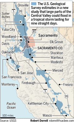
In the study, researchers used computer models and a composite of three historical storms to estimate a worst-case event: a torrent of tropical rain for nine straight days.
It amounts to a 500-year storm. In the lingo of disaster managers, that does not mean it happens only once every 500 years, but that it has two-tenths percent chance of occurring in any given year.
The Central Valley and the Sacramento region are likely to suffer the worst effects because they lie within a funnel for the state's biggest rivers.
Such storms have happened. The primary example in the study occurred over December and January, 1861-62. Rain fell on and off for 45 days. Sacramento was inundated, and Gov.-elect Leland Stanford famously took a rowboat to his inauguration.
The researchers used soil samples to estimate that similar megastorms hit the state on at least six other occasions in the past two millenia, at 200- to 400-year intervals.
Of course, a lot has changed since 1861 - for better and for worse. Central Valley levees are generally stronger and more comprehensive now. On the other hand, millions more people and more economic activity depend on those levees.
The report acknowledges that some experts disagree with the severity of the scenario, especially in Sacramento and the Sacramento-San Joaquin Delta.
Joe Countryman, president of MBK Engineers in Sacramento, who has decades of flood-control experience in the region and saw a draft of the study several months ago, said it lacked detailed analysis of reservoir operations and river flow capacity.
"As an exercise to test emergency procedures, OK. I'm not against it," he said. "It seems to me much bigger than anything could actually be."
But the researchers also note that none of the levees is built for a 500-year storm. The best - such as those in Yuba County's Plumas Basin and parts of Sacramento - are built for a 200-year storm.
Potential consequences include:
- $1 trillion in damages statewide - five times worse than a massive earthquake, which likely would affect only one region.
- 1.5 million people displaced, about the same number affected by Hurricane Katrina in New Orleans in 2005.
- Potentially hundreds of people killed, based on the inability of some vulnerable groups to evacuate, or for help to reach them.
- Pollution from flooded wastewater treatment plants, refineries and dairies. Some sewer plants might not return to operation for months.
"For a lot of people in California, we don't think of ourselves as being this flood-prone," said Laurie Johnson, an urban planning and disaster recovery expert, and co-author of the report. "It's just too difficult to comprehend."
What should people do?
Anyone living behind levees should buy flood insurance, Jones said. Only 12 percent do currently.
Citizens can also support urban planning efforts to steer development away from floodprone areas, and support continued levee improvements.
The study estimates that upgrading urban levees to withstand the worst-case storm might cost $25 billion - a sum that pales next to the potential for hundreds of billions in storm damages.
Officials hope emergency planners use the ArkStorm report to prepare for the worst.
The next step is to develop a storm-rating scale similar to that used for hurricanes. It would assign a number to a storm based on predicted severity.
ArkStorm report can be found here: [Link]