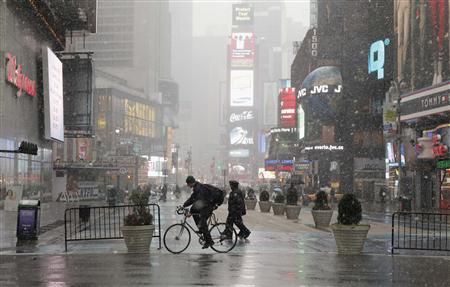
© Reuters/Lucas JacksonSnow falling in Times Square, January 7, 2011.
Snow fell across the mid-Atlantic and Northeast states on Friday, bringing several inches of fresh accumulation to a region that has scarcely dug out from the Christmas weekend blizzard.
The latest winter storm will drop snow from the Great Lakes east to the Atlantic seaboard and New England throughout Friday and into early Saturday, forecasters said.
The Northeast could see one to five inches of snow from Maryland north into Pennsylvania, New York and Connecticut, forecasters said. Two to four inches accumulation was likely in New York City, they said.
One to three inches were forecast for Philadelphia, Wilmington and Atlantic City, according to Accuweather.com.
Accuweather.com senior meteorologist Alex Sosnowski said Northeast weather would feature "a great deal of little storm systems or disturbances running around through the weekend."
"Pretty much anybody in the Northeast is fair game for a sneak attack from a coating of snow into Sunday," he said. "It is almost like atmospheric guerrilla warfare."
While not as powerful as the late December blast, this storm was snarling travel, with delays of nearly three hours inbound for LaGuardia and John F. Kennedy International airports and slightly less at Newark Liberty International.
Further west, snow showers swept across southwestern Pennsylvania overnight.
"I couldn't get my car out of my driveway this morning," said Robert Kimble, a construction worker waiting for a bus in Pittsburgh. "Too much snow."
The storm was not likely to approach the scale of the Christmas weekend blizzard, however, which pummeled the mid-Atlantic and Northeast. That storm dropped some 20 inches of snow in New York City, where many streets went unplowed for days and trains, buses and subways ground to a halt.
A federal and several local investigations have been launched to determine why the cleanup was slow and inefficient, and Mayor Michael Bloomberg has vowed the city will be better prepared and more efficient this time around.
On Tuesday or Wednesday, a big coastal storm was likely to arrive off the East Coast, the National Weather Service said.
The South will get its latest wintry blast over the weekend, said Mark Avery, lead meteorologist for The Weather Channel, with "some significant snow accumulations."
"The wintry side of this storm will really begin to show up on Sunday," Avery said. "Snow is expected from Arkansas into the western Carolinas, with accumulating snow possible in northern parts of Mississippi, Alabama, Georgia, and South Carolina."
A winter storm was expected as well over the central Plains, with snow in Wyoming, Montana, the Dakotas and Nebraska, moving east toward Missouri, forecasters said.
In the West, dense fog and smog plagued the Wasatch Front in heavily populated areas of Utah on Friday.
"It's been a problem most of the week, the smog, patchy dense fog in the lower valleys," said meteorologist Mike Conger with the National Weather Service in Salt Lake City.
Snow was accumulating in northern Utah, and a cold front was aiming for the state as well, which should bring some relief in terms of the air quality, officials said.
In Washington state, a cold front was blowing in from the Pacific Ocean. Three to four inches of new snow were anticipated at Snoqualmie Pass, a thoroughfare to Seattle from eastern Washington, on Friday.

Reader Comments
to our Newsletter