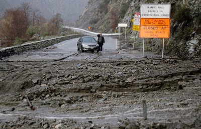
The storm brought winds of up to 80 mph and waves recorded at up to 20 feet. The brunt of the storm has moved to the east, but more showers and isolated thunderstorms are forecast through Friday.
[Updated 4:16 p.m.: Acting Governor Edmund G. Brown Jr. today proclaimed a state of emergency in Los Angeles, Orange, Riverside, San Francisco and Siskiyou counties due to the series of storms. In a prepared statement, Brown cited the loss of human life, injuries, flooding, heavy snows, loss of power and mudslides as reason for the state of emergency. Gov. Arnold Schwarzenegger is currently in Washington D.C.]
Ventura County fire officials said that they had received reports that a tornado touched down in the eastern end of the city of Ventura near North Bank Drive and Montgomery Avenue, downing power lines and causing damage to cars, outbuildings and agriculture, as well as toppling a tree into a home.
There were no immediate reports of injuries, but Ventura County Fire Department spokesman Bill Nash said officials are still assessing the damage.
"There is more than a mile-long path of destruction," Nash said. "It's a pretty serious situation."
Ventura County Sheriff's Sgt. Jack Richards said fire and law enforcement personnel were going house to house in two neighborhoods and an agricultural area.
Richards said police interviewed at least four witnesses who reported seeing a funnel cloud touch down. "It picked a Chrysler Sebring off the ground, it hovered for second and spun it around," Richards said. "It hit a tree and blew out the rear and side windows."
He said it also uprooted some trees. "It plucked them right out of the ground like a eyebrow," Richards said. "It also tore the roofs off some sheds."
The National Weather Service has not yet classified the winds in that area as a tornado. The agency said a tornado watch had been issued for eastern Riverside County.
Southwest Airlines is suspending and canceling flights arriving and departing this afternoon at its airports in Burbank, Ontario, Orange County, San Diego, Phoenix and Tucson, citing high wind conditions.
Flights at Bob Hope Airport in Burbank and Los Angeles/Ontario International Airport were suspended after 1 p.m., and airline officials said they tentatively plan to resume service at those airports after 6 p.m., when the current storm is expected to clear out. The majority of flights were canceled for the rest of today at John Wayne Airport in Orange County and at airports in San Diego, Tucson and Phoenix
At John Wayne Airport, Dartagnan Pendleton, 41, stared at the flight board, assessing his options. There weren't many.
"Yeah it is a big deal," he said. "My father is a quadriplegic and his wife is going away on business tomorrow and I need to be there to take care of him."
He said he was considering taking a flight to Fresno on another airline or even renting a car in Orange County and driving to Oakland. "I don't know whether I can get through on the 5" Freeway, he said.

"If I don't get home by tomorrow morning, my wife's going to be upset," he said. "She has plenty of things to do."
The California Highway Patrol this morning shut Interstate 5 at the Grapevine because of heavy snow. The CHP also said road visibility was down to zero on some roads in Temecula.
The National Weather Service issued flood warnings for large swaths of Southern California. The worst of the rain pounded Orange County and the Inland Empire.
According to the agency, the barometric pressure at Los Angeles International Airport fell to 29.20 inches of mercury, breaking a record set in 1988.
The storm's main front could bring 0.5 to 0.75 inch of rain an hour, forecasters said, warning of possible thunderstorms that could increase that figure to more than 1 inch an hour. The rain is expected to lessen tonight, but showers are possible Friday.
The weather service is warning of life-threatening mud and debris flows in areas stripped of vegetation by last year's Station fire. About 1,000 homes have been ordered evacuated.
Residents in La Cañada Flintridge, La Crescenta and Acton were told they may have to stay away from their homes until Monday, said Nicole Nishida, a spokeswoman for the Los Angeles County Sheriff's Department. About 500 homes in those areas were under mandatory evacuation orders, and about 75% of residents had left their homes.
"That is a long time, but we want them to be safe," Nishida said, adding that residents could be allowed back earlier.
Rain tapered off this morning in La Cañada Flintridge, but Nishida warned that the ground was still saturated.
"We aren't out of the woods yet," she said.
Evacuation orders were still in effect for 262 homes in south Tujunga Canyon, said Deputy Operations Chief Lt. Jeffrey Bert of the Los Angeles Fire Department. Residents were being escorted back on a case-by-case basis, he said.
"Some people might need medicine, but we strongly encourage people to stay evacuated," Bert said.
On Ocean View Boulevard in the La Cañada-LaCrescenta area this morning, it was sprinkling lightly. Some L.A. County cleanup crews were mopping up minor mudflows and other debris from overnight runoff.
Officials are gearing up for mudslides that are predicted to hit the areas denuded by the wildfires; they also warned several hundred residents who opted to ignore evacuation orders that they should leave.
Debris basins and flood control channels in the La Cañada Flintridge, Acton and La Crescenta areas, as well as the Tujunga Canyon area, are nearly at capacity, which could cause mudslides if a hard rainfall occurs, said Gail Farber, Los Angeles County's public works director.
No major incidents of debris flows or runoff were reported early this morning, Farber said, but she warned that "the storm is not over."
About 3,000 customers in Brentwood and Koreatown did not have power this morning after their electricity was knocked out late Wednesday because of the storm, said officials with the Los Angeles Department of Water and Power, who also warned that the storm could down power lines, creating hazards.
About 5,400 residents in Valencia, Phelan, Chino Hills, Rowland Heights and Whittier remained without power this morning, according to Southern California Edison.
Scattered showers were reported this morning, the leading edge of the big storm. The rain caused numerous accidents, jamming the morning commute. In Long Beach, which has been hard hit by this week's rain, the mayor urged residents to avoid driving today if possible, and Cal State Long Beach was closed.


Reader Comments
to our Newsletter