|
| ©REUTERS/NOAA/Handout |
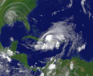
| Hurricane Hanna is seen southwest of Nassau in a satellite image taken September 2, 2008. |
These followed on the heels of Hurricane Gustav, which began to dissipate on Tuesday after slamming ashore on the U.S. Gulf Coast near New Orleans the day before. The new tropical cyclones threatened vast areas, from South Carolina in the United States to the Caribbean islands.
The flurry of storms was the latest evidence that predictions for a busier than normal season were on the mark, and was worrisome news for U.S. oil and natural gas producers in the Gulf of Mexico, millions living in the Caribbean and on U.S. coasts, and farmers fearing flooded fields.
The U.S. government has forecast that 14 to 18 tropical storms will form during the six-month season that began on June 1, compared to a historical average of 10. The new tropical depression on Tuesday was already the 10th, forming before the statistical peak of the season on September 10.
Hanna's 70 mile per hour (110 km per hour) winds meant it was just short of being a Category 1 hurricane on the five-step Saffir-Simpson scale of storm intensity. Its slow movement, however, meant it was dumping torrential rains on the southeastern Bahamas and the Turks and Caicos islands.
"Although little change in strength is expected during the next 24 hours, Hanna could regain hurricane strength later today or tomorrow," the Miami-based hurricane center said.
TURN NORTHWEST
Hanna was expected to turn to the northwest and come ashore at the end of the week somewhere between northern Florida and the Carolinas as a Category 2 hurricane, it said. The hurricane center had said earlier that Hanna could become a major hurricane by landfall.
Major hurricanes are those that rank Category 3 and higher and are the most dangerous. Hurricane Katrina was a Category 3 when it swept ashore and flooded New Orleans in 2005. Gustav also was a Category 3 shortly before landfall but weakened before it hit on Monday.
Hanna could approach the heavily populated Miami-Fort Lauderdale area, but the official forecast kept the hurricane well offshore from south Florida.
Tropical Storm Ike meanwhile moved briskly westward after forming on Monday midway between Africa and the Caribbean and appeared likely to become a hurricane that would threaten the Caribbean islands and possibly the United States.
It was too early to say where Ike might go, but energy companies running the 4,000 offshore platforms in the Gulf of Mexico that provide the United States with a quarter of its crude oil and 15 percent of its natural gas will pay attention to it next week.
Meanwhile, the Atlantic hurricane season's 10th tropical depression -- precursors to tropical storms and hurricanes -- formed south of the Cape Verde Islands, an area known as a breeding ground for some of the strongest hurricanes.
Moving west at 16 mph (26 kph), the system would be called Josephine when it becomes a tropical storm with winds of 39 mph (64 kph) and was expected to become a hurricane by Saturday.


Reader Comments
to our Newsletter