|
| ©Jeff Schmaltz |
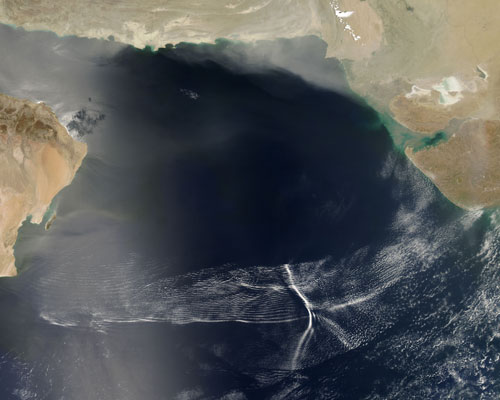
The wave of cool, dry air pushes forward until it meets the wall of warm, moist air that blankets the Arabian Sea. When the two air masses clash, the cool air pushes the warm air up. The warm air rises, cools at the peak of the wave, falls again, and then rises to a slightly lower peak, and repeats this action until the wave dissipates. Clouds form at the high-altitude peaks of the waves, with the most defined cloud at the front of the group, where the initial wave formed, followed by increasingly less-defined lines of cloud.
The air that moves in front of the low-pressure system does not push forward in a uniform wall; instead it pushes forward in a ragged band, with one part racing ahead of another, like a line of crew racers on a river. Because the air is not uniform, small, interacting arcs of waves appear within the larger band of clouds.
Undular bores are rare and hard to predict. This particular undular bore formed over the Arabian Sea on May 8, 2007, when the Moderate Resolution Imaging Spectroradiometer (MODIS) on NASA's Aqua satellite captured this photo-like image. Typical undular bore patterns might display one or two rows of clouds, but this one contains more than thirty waves of clouds. Some secondary air mass, perhaps a jet of warm tropical air, cuts across the center of the wave pattern, creating a long vertical cloud.


Reader Comments
to our Newsletter