Earthquakes
S


Attention

Earthquake triggers strong eruption at Sinabung volcano on Sumatra, Indonesia

Sinabung volcano
Sinabung volcano
A strong explosion was recorded at Sinabung volcano on January 9, 2016.

It was triggered by a volcanic earthquake that occurred about 8 minutes before.

The powerful explosion occurred at 21:48 pm and sent a column of ash and gas 3km in the air.

There was a volcanic earthquake for 490 seconds when the eruption occurred.

Ashfall was recorded in Berastagi City.

An exclusion zone has been implemented in a radius of 3 km around the volcanic peak.


Sinabung volcano
Sinabung volcano

Seismograph

Third shallow earthquake rattles Central New Zealand within a fortnight, magnitude 5.1

Earthquake road
The year 2017 has not been lucky enough for Central New Zealand as the country has been hammered by two earthquakes within a week and today as well, another quake shivered Central New Zealand.

A 5.1 magnitude quake struck Central New Zealand near Seddon this afternoon. As per Geo Net, the epicenter of the quake was 15 km southeast of Seddon and was 11 km under the earth's crust.

The quake shivered the country struck at around 1.19 pm (local timings) this afternoon. The shake was felt as distant as Auckland, however, it was the strongest in Blenheim and Wellington. Other remote areas where the tremors were felt include Hamilton, Taranaki, Westport and Richmond.

Comment: See also these reports of the prior earthquakes: Shallow 5.3 earthquake shakes Central New Zealand

'Severe', shallow magnitude 5.5 earthquake strikes central New Zealand


Seismograph

Strong shallow 6.4 magnitude earthquake recorded near Solomon Islands

map epicentre
A strong 6.4 magnitude earthquake struck on Tuesday off the Solomon Islands in South Pacific, the US Geological Survey (USGS) agency warned.

The underwater quake hit 67 miles northwest of Kirakira, the capital of the Makira-Ulawa province, at the depth of 28 miles.
Strong M6.4 earthquake hits near Makira, Solomon Islands https://t.co/gjT48FzGAJ #earthquake #SolomonIslands

— The Watchers (@TheWatchers_) 10 января 2017 г.
​The US National Oceanic and Atmospheric Administration (NOAA) measured the tremor at 6.7 magnitude but said a tsunami was not expected.

The Oceanic island nation is part of the so-called Ring of Fire quake zone. It is a strip of volcanoes and tectonic faults in the Pacific basin and has one of the highest levels of volcanic and seismic activity in the world.

Seismograph

Strong 7.3 magnitude undersea earthquake strikes near the Philippines

Celebes Sea quake map
© USGSThe point where the earthquake struck.

Quake measured at a depth of 617 km, according to the US Geological Survey


A major undersea earthquake with a magnitude of 7.3 struck southeast of the Philippines on Tuesday, the US Geological Survey (USGS) said.

The quake was measured at a depth of 617 km (380 miles), the USGS said. It struck in the Celebes Sea and comes five days after a smaller, 4.7-magnitude tremor in the same area, according to the USGS.

Journalist Barnaby Lo said he felt "no significant tremor" on the island of Jolo, which lies north-east of the epicentre. The US Tsunami Warning Centre has issued no warning, advisory, watch or threat after the quake.

Philippine seismologists said the earthquake was far too deep to cause any damage and casualties or generate a tsunami.

Seismograph

Earthquake of magnitude 3.5 recorded at Bárðarbunga volcano, Iceland

Bárðarbunga.
© Páll Stefánsson.Bárðarbunga.
An earthquake of magnitude 3.5 occurred in the northern caldera of Bárðarbunga volcano in Vatnajökull glacier shortly before noon yesterday. A few aftershocks followed, the largest of which measured 2.3 magnitude.

The Icelandic Met Office, which reported the seismicity, stated that there were no indications of volcanic activity in the area, ruv.is reports.

Bárðarbunga caused the 2014-2015 eruption in Holuhraun in the northeastern highlands.

Seismograph

Shallow 4.9 magnitude earthquake recorded at Antirrio, Greece

GRAPH
4.9 magnitude earthquake 2 km from Antirrio, West Greece, Greece

2017-01-09 09:53:17 UTC

UTC time: Monday, January 09, 2017 09:53 AM

Your time: 2017-01-09T09:53:17Z

Magnitude Type: mb

USGS page: M 4.9 - 6km NNW of Rion, Greece

USGS status: Reviewed by a seismologist

Reports from the public: 4 people

2017-01-09 09:53:17 UTC 4.9 magnitude, 10 km depth

Seismograph

Magnitude 3 earthquake recorded under Teide volcano, Canary Islands

Location of today's earthquake under Teide volcano
Location of earthquake under Teide volcano
Teide volcano (Tenerife Island, Canaries): magnitude 3 earthquake under the volcano

A shallow magnitude 3 earthquake occurred almost directly under the summit of Teide volcano in 3 km depth today (at 12:18 UTC).

Whether the quake is volcanic in origin and might be a sign of a gradual reawakening of the volcano is impossible to say, but it is important to follow the volcano's seismic activity closely.

Seismograph

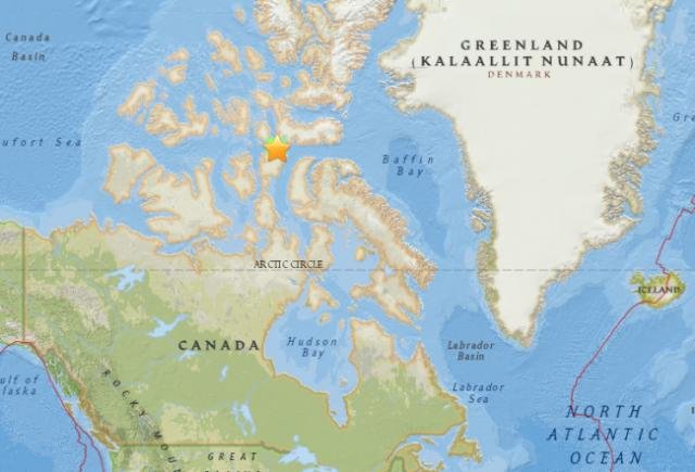
5.8 magnitude earthquake shakes Nunavut, Canada

Nunavut earthquake map
© U.S. Geological SurveyScreenshot showing the site of the earthquake.
A magnitude 5.8 earthquake struck around 89 km southeast of the Inuit hamlet of Resolute in Nunavut, according to the U.S. Geological Survey and Earthquakes Canada.

The quake was detected at 5:47 pm, with its epicentre located in the Barrow Strait waterway. It was initially measured at magnitude 6.4 before being downgraded.

There are no reports of deaths or casualties at this time.

An Earthquakes Canada seismologist told Global News that there is likely little cause for major concern given the distance of the epicentre from Resolute.

"I would expect the damage to be pretty minor, if there was any," Nick Ackerley said.

Resolute has a population of around 240, and is the second most northerly community in Canada.

The last earthquake to hit the Barrow Strait occurred in December 1987, and was measured at a magnitude of 5.4.

Seismograph

Shallow 5.1 magnitude earthquake strikes west of Port Hardy, Canada

5.1 magnitude Earthquake strikes west of Port Hardy
A 5.1 magnitude earthquake has struck 186 kilometres west of Port Hardy, on the northern tip of Vancouver Island.

According to the U.S. Geological Survey, the quake was reported at 7:49 a.m. Pacific Time. It occurred at a depth of 10 kilometres.

Pacific Tsunami Warning Center has not issued a tsunami warning, watch or advisory for the pacific coast.

In an online post, Natural Resources says there are no reports of damage and none would be expected.

The quake occurred in the seismically active area along the Cascadia subduction zone off Vancouver Island, where two plates of the earth's crust meet.

Comment: Also today:


Seismograph

Shallow 5.3 earthquake shakes Central New Zealand

GRAPH
People in Central New Zealand woke up to a severe earthquake of magnitude 5.3. The quake which rattled the country once again within a span of ten days was felt by thousands of citizens.

As per Geonet, the quake struck 20km southwest of Seddon in Marlborough at around 12:17 am early Friday. The earthquake was just 13km deep and was widely felt.

So far reports of any injuries or damages have not been reported though the quake was felt by more than 6300 people from Auckland to Invercargill. The lower half of the North Island and top of the South Island is said to have felt more aftershocks.The quake has been described as a short, fierce quake and it trembled homes overnight and set hearts battling.

USGS data