Earthquakes
S


Bizarro Earth

Magnitude 6.2 earthquake hits region in eastern Indonesia

Earthquake
A 6.2-magnitude earthquake was felt in the Indonesian resort island of Bali early Friday (Dec 30), an AFP correspondent said, but there was no tsunami alert and no immediate reports of casualties or damage.

The quake hit around 300 kilometres east of Bali at a depth of around 72 kilometres just off the island of Sumbawa at 6.30am (2230 GMT Thursday), the US Geological Survey said.

"The earthquake was quite long. Most people had just woken up and they started running out from their homes. My family and I also ran away because we were afraid," Djunaedi Garib who lives in Hambala, southeast of the epicentre, on the island of Sumba told AFP.

In an initial assessment, the USGS said there was a low likelihood of casualties or damage. Indonesia's disaster agency said officials were checking to see if the quake had had any impact.

Indonesia experiences frequent seismic and volcanic activity due to its position on the Pacific "Ring of Fire", where tectonic plates collide.

Source: Agence France-Presse

Seismograph

'Severe', shallow magnitude 5.5 earthquake strikes central New Zealand

New Zealand's south island quake map
© USGSThe area where the quake struck off New Zealand's south island
A magnitude 5.5 earthquake has struck central New Zealand on Thursday afternoon.

According to RNZ, the strong quake was centered around 35km east of Seddon, a town on the northern tip of New Zealand's south island.

The quake, which hit at 3.34pm, had a depth of 15km and was followed soon after by a 4.7 aftershock.

GeoNet rated the intensity of the earthquake as 'severe'.

Shaking was felt in Wellington more than 150km away.

The island has been hit by several aftershocks following the devastating 7.8-magnitude quake which struck in November.

The New Zealand Herald reported that no injuries or damage had been reported to the Wellington Free Ambulance or St John central communications.

Comment: Earlier this month the same area was rocked by another severe, shallow magnitude 5.5 earthquake; and two earthquakes in two minutes, one of them strong.


Attention

5.9 magnitude earthquake hits Ibaraki Prefecture in Japan

Ibaraki earthquake
© USGS
An earthquake has struck the eastern coast of Japan, with early reports suggesting a magnitude 5.9 quake, according to the United States Geological Survey (USGS).
USGS report
© USGS
The Japanese Meteorological Agency (JMA) earlier put the magnitude at 6.3 and reports the quake had a depth of 10km.

Reuters reports that no tsunami warning has been issued as a result of the quake.

The epicenter was reported as Ibaraki Prefecture in central Japan, about 170 kilometers north of the capital Tokyo, and near the town of Daigo. The prefecture has a population of about three million people.

Japan's NHK news agency report that tremors were felt throughout "wide areas" of the east coast, although it is unclear how much damage has been caused.

NHK reports that the JMA will hold a press conference at 11:45pm local time to provide further information on disaster prevention and earthquake activity.

In 2011, the 9.0 magnitude Tohoku earthquake caused large scale destruction of Japan's Fukushima Daiichi nuclear power plant, which remains one of the biggest environmental disaster zones on the planet.

Seismograph

Three large quakes hit near Nevada-California state line

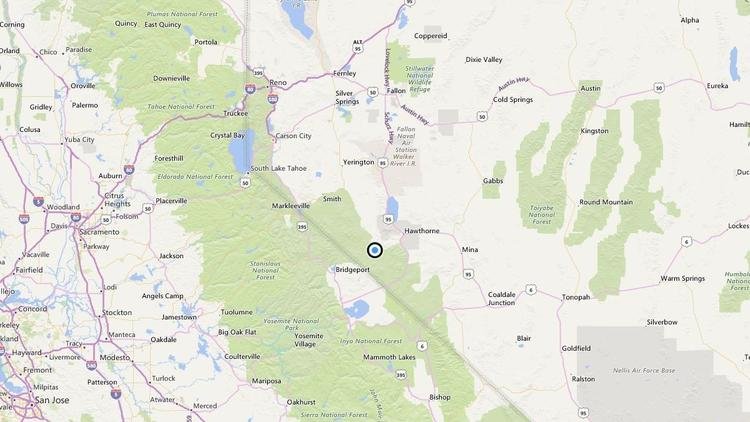
Three large quakes hit near Nevada-California state line A map showing the location of the epicenter of Wednesday morning's quake near Hawthorne
© BingA map showing the location of the epicenter of Wednesday morning's quake near Hawthorne, Nevada
A series of earthquakes were reported Wednesday morning near the Nevada-California state line, according to the U.S. Geological Survey.

The first temblor occurred at 12:22 a.m. Pacific time with a magnitude of 5.7 near Hawthorne, Nevada. At least seven quakes with magnitudes between 3-5.6 were reported shortly after.

Light shaking was felt as far away as South Lake Tahoe, Fresno, Visalia and Merced.

Comment: See also:


Seismograph

Magnitude 5.6 quake hits eastern Romania

Seismograph
© Flickr/ Matt KatzenbergerSeismograph
A 5.6-magnitude earthquake occurred 8 kilometers (about 5 miles) west of Romania's eastern city of Nereju, the US Geological Survey (USGS) reported.

The earthquake occurred at 23:20 GMT at a depth of 81 kilometers, according to the USGS.

No information on casualties or damage from the quake has been provided to date.

Seismograph

5.2 magnitude earthquake strikes off Philippines

Philippine Coast Guard and Police Maritime unit
© AP Photo/ Bullit MarquezPhilippine Coast Guard and Police Maritime unit
The earthquake occurred at 01:23 GMT on Monday at a depth of 10 kilometers (approximately 6 miles), 61 kilometers (about 38 miles) north of Namuac, a city located in the Philipinne Cagayan Valley region, according to the USGS.

​No information on casualties or damage from the quake has been provided to date.

Attention

7.7 magnitude earthquake hits off coast of Chile, tsunami threat issued

Chile earthquake
© USGS
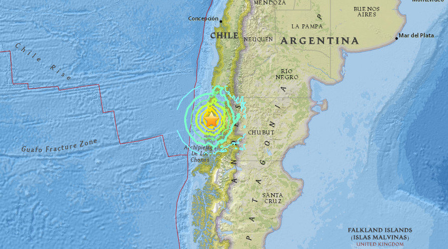
An earthquake of 7.7 magnitude was registered in southern Chile on Sunday, prompting a tsunami threat message for areas as far as 1,000 kilometers (620 miles) from the epicenter.

The quake's epicenter was 225km (140 miles) southwest of Puerto Montt in southern Chile, according to the United States Geological Survey (USGS), with a depth of about 15km (nine miles).

The National Emergency Office of the Chilean Interior Ministry and Public Security (ONEMI) has warned people in the coastal regions to leave the areas due to the tsunami threat.

People in the Biobio, Araucania, Los Rios, and Aysen regions have been advised to evacuate, ONEMI said on its official Twitter account.

Based on the Pacific Tsunami Warning Center's threat messages, "hazardous tsunami waves are forecast for some coasts." An earlier message said tsunami waves were "possible" within a 1,000km radius from the epicenter. Tsunami waves of up to three meters above the tide level might reach some coasts of Chile, it said.
Seismograph

Series of shallow earthquakes hits Siargao Island, Philippines

Graph
A series of earthquakes struck Siargao Island, Surigao del Norte province yesterday, the Philippine Institute of Volcanology and Seismology (Phivolcs) said.

In its bulletin, Phivolcs said the first earthquake was measured at magnitude 4.5 and registered at 12:09 a.m. The epicenter was plotted 24 kilometers (km) northeast of San Isidro town, Siargao Island, Surigao del Norte, with a depth of 10 kms.

An intensity 3 quake was also recorded in Surigao City, Phivolcs said.

At 1:35 a.m., a 4.3-magnitude tremor was registered in the same area, with its epicenter traced 40 km northeast, with a depth of only six kms.

Another 4.3 magnitude earthquake was recorded at 2:16 a.m. with the epicenter located 42 kms northeast of that same town, with a depth of nine kms., Phivolcs said.

Seismograph

Several earthquakes, 1 of magnitude 3.5, strike north Oklahoma

Graph
The U.S. Geological Survey says several earthquakes have struck northern Oklahoma, including one with a preliminary magnitude of 3.5.

No injuries or damage are reported from the quakes that occurred Friday afternoon near Mooreland, about 108 miles northwest of Oklahoma City.

The 3.5 magnitude quake was recorded about 2:45 p.m. Friday, followed aftershocks with preliminary magnitudes ranging from 2.5 to 3.3.

Geologists say damage is unlikely in earthquakes below magnitude 4.0.

Thousands of earthquakes have been recorded across Oklahoma in recent years, and many have been linked to the underground disposal of wastewater from oil and natural gas operations. Regulators have asked oil and natural gas producers to close injection wells in certain areas or reduce the volume of fluids they inject.

Source: AP

Seismograph

Shallow earthquake of magnitude 4.4 felt in Dubrovnik, Croatia

earthquake map
More earthquake activity near the Adriatic coast in the early hours of December 24, 2016.

A strong earthquake with a magnitude of 4.4 has been felt in Dubrovnik and the surrounding areas. It's epicentre is in Montenegro, at a depth of 13 kilometres. The earthquake struck at 00:39 on Christmas Eve, and follows the recent tremor near Split which registered 4.8 on the Richter scale.

As things currently stand, there is no report of any material damage.