Earthquakes
S

Seismograph

Magnitude 5.1 earthquake takes 4 lives in southern Iran

GRAPH
An earthquake measuring 5.1 on the Richter scale hit Khonj city in southern Iranian province of Fars leaving four people dead.

Managing Director of Crisis Management Center at Provincial Governor's Office of Fars Province Hassan Fayazpour said the earthquake had struck four villages in Khonj region at 06:30 local time.

The official, while noting that the epicenter of the quake was in an area at longitude of 53.18 and latitude of 28.11, said the earth tremor was first believed to have only left financial losses though deployment of rescue teams reveled that four people had been killed.

USGS data

Bizarro Earth

2016 saw highest natural disaster losses in four years at $175 billion

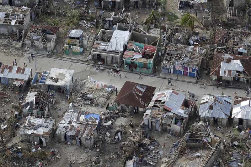
Hurricane Matthew hits Haiti
© Rebecca Blackwell/AP These houses in southwestern Haiti were damaged or destroyed by Hurricane Matthew in October. Matthew was the most serious natural catastrophe in North America in 2016.
Hurricane Matthew. The earthquake in Japan. Flooding in the Deep South, China and Europe. Wildfires in Canada.

Last year sometimes felt like one natural catastrophe after another. Now, new figures from reinsurer Munich Re suggest that it was indeed a particularly bad year.

Natural catastrophes caused the highest losses worldwide in the last four years, at $175 billion, Munich Re said. It recorded some 750 events globally, including "earthquakes, storms, floods, droughts and heatwaves." The reinsurer added that about 30 percent of those losses were insured.

North America "experienced 160 loss events in 2016, the most since 1980," the reinsurer added.

Globally, the costliest single event was the devastating earthquake on the Japanese island of Kyushu, at $31 billion. Here's the breakdown of the five most costly disasters worldwide:

Seismograph

Rare M3.9 earthquake hits Sydney, Australia; Government urges calm

Sydney earthquake map
A 3.9-magnitude earthquake hit south of Sydney.
A small, rare earthquake has rattled Sydney, but Australian government officials are urging locals not to panic.

The 3.9 magnitude quake was centred 16km south of Campbelltown and struck at 1.13am (3.13am NZT).

According to Geoscience Australia, the quake would have been felt 56km from its epicentre.

Local MP Jai Rowell told his constituents to remain calm.

"It is hard to believe that we have had an earthquake in Wollondilly but we have," he said on Facebook.

He reminded locals to report any damage or injury to emergency services. There are currently no reports of damage.

Attention

3.9 magnitude tremor strikes off UK coast - biggest quake for nearly a decade

Scarborough coastline earthquake
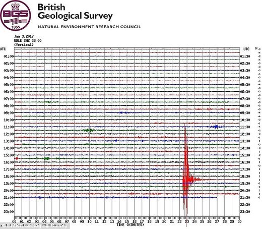
The earthquake, at 6.52pm, was spotted by the monitoring station at Scarborough and showed up on the seismograph (pictured)
The largest earthquake to hit Britain for almost a decade was felt in North Yorkshire on Tuesday evening.

The tremor measuring 3.9 on the Richter Scale happened in the North Sea 100 miles east of Scarborough at 6.52pm, the British Geological Survey said.

Although the British Isles are not at risk of a devastating earthquake bringing widescale destruction or mass casualties, it is thought 20 to 30 minor movements happen each year.

Yesterday's quake was the largest since a 5.2 magnitude tremor hit Market Rasen, Lincolnshire, in February 2008.
It was felt as far away as Aberdeen and Ireland.

The largest earthquake ever recorded in the UK measured 6.1 and happened on Dogger Bank, in the North Sea, in 1931.

The most destructive was around Colchester, Essex, in 1884, measuring 4.6 on the Richter Scale. Some 1,200 buildings needed repairs, chimneys collapsed and walls were cracked, the British Geological Survey said.

It was 60 miles offshore but was still powerful enough to cause minor damage to buildings on the east coast of England.

The British Geological Survey said on its website that earthquakes on the east coast of the UK are relatively rare.
Bizarro Earth

Magnitude 7.2 earthquake strikes off Fiji

Fiji Earthquake
© earthquake.usgs.gov/Reuters
An earthquake with a preliminary magnitude of 7.2 has struck off the coast of Fiji, according to the US Geological Survey.

The quake centered some 221 km southwest of Nadi at a depth of 15.2 km, the USGS said.

Tsunami waves are possible for coasts located within 300 kilometers of the earthquake epicenter, the Pacific Tsunami Warning Center has warned.

The PTWC stressed that based on available data, there is no tsunami threat to Hawaii and only "parts of the Pacific located closer to the earthquake" are at risk.

Tsunami waves, according to the PTWC, are expected to reach Suva, the capital of the South Pacific island nation of Fiji at 10:45pm GMT.

Seismograph

Woman dies as 5.7 magnitude earthquake hits India-Bangladesh border

India-Bangladesh earthquake map
© USGSMagnitude 5.7 earthquake hit India-Bangladesh border region.
One women was killed and few other injured when a moderate earthquake measuring 5.7 magnitude on the Richter scale hit Tripura on Tuesday, triggering landslides in the hill state and jolting the country's northeast region.

There was no report of any major damage from other states, officials said.

The epicentre of the quake was Dhalai in northern Tripura at a depth of 28 km.

Kamalini Kanda, 50, died of heart attack out of fear during the tremor at Kamalpur in Dhalai district in Tripura, an official of the Tripura Disaster Management Centre said.

Five other people were injured in different parts of the state during the quake.

The official said at least 50 house were damaged, some badly, as landslides occurred in different places of Dhalai district. The earthquake blocked roads after trees were uprooted.

The quake hit most states of the northeastern region at 2.39 pm, triggering panic.

Attention

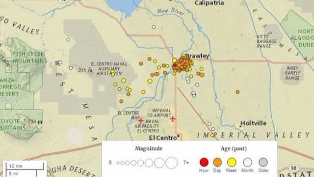
Earthquakes continue at California-Mexico border, 250 small quakes since New Year's Eve

Brawley earthquakes map
© USGSThis map, generated about 5 p.m. on Jan. 1, 2017, shows the Brawley earthquake swarm that began on New Year's Eve.
A swarm of more than 250 small earthquakes have struck since New Year's Eve near the California-Mexico border, causing unease among residents and attention from scientists.

The strongest earthquake in the sequence was magnitude 3.9, striking directly underneath the town of Brawley, about 170 miles southeast of Los Angeles.

The earthquakes struck in the southern end of the Brawley Seismic Zone, a seismically active region where tectonic plates are moving away from each other and the Earth's crust is getting stretched out "and basically adding land," said Caltech seismologist Egill Hauksson.

The Brawley Seismic Zone is particularly important to watch because it is the region that connects the San Andreas and Imperial faults, both of which can produce damaging earthquakes. The seismic zone extends for about 30 miles from the city of Brawley, across the Salton Sea's southern half, and ends near Bombay Beach.

Comment: Swarm of 100 small earthquakes strikes near California-Mexico border


Seismograph

6.0 Magnitude Earthquake South of Fiji Islands

Graph
UTC time: Monday, January 02, 2017 13:14 PM

USGS page: M 6.0 - South of the Fiji Islands

2017-01-02 13:14:02 UTC 6.0 magnitude, 549 km depth

Bizarro Earth

Year of rumbles - New Zealand had the most earthquakes in 2016

Earthquake Damage
© Getty ImagesDamage at the Waiau Lodge Hotel in Kaikoura after an earthquake on November 14.
They're not called the shaky isles for nothing.

New Zealand experienced a record breaking 32,828 earthquakes in 2016.

There were also 80,000 landslides, two tsunamis and a volcanic eruption to cap off a year described by GeoNet as "the groundbreaker".

The previous biggest year was 2011 - the year of the deadly Christchurch earthquake - when 29,000 were recorded, compared to the usual average of 20,000 a year.

"You'd be hard pressed to find someone who wasn't impacted, in some way, by earthquakes in New Zealand this year," GeoNet's Sara McBride wrote in a blog post.

Usually quake-immune Auckland felt the ground rumble during the first of two magnitude seven quakes.

Normally the country only gets one quake a year above a magnitude seven, so when a 7.1 hit the northeast coast in September causing minimal damage on land, many thought that box had been ticked.

But earthquake-weary Christchurch and the often-shaky capital Wellington were rocked again by the devastating Kaikoura magnitude 7.8 earthquake just two months later.

Bizarro Earth

Residents in Oswego County, NY report possible explosion, earthquake in Southern Tier

broome couty NY
People from Owego to Broome County reported feeling an "explosion" noise around 5 p.m. Saturday. WICZ reports that residents from Broome County all the way down to Northern Pennsylvania have reported odd shaking and felt their houses and windows shake.

According to WICZ the Tioga County Sheriff's Department did not say if they received any calls. They told WICZ they "have no comment or information at the moment."

The Broome County Sheriff's office told WICZ about reports coming from social media about "a yellow cloud of smoke."

Though they did not receive any calls about any clouds. They continued investigating those claims Saturday afternoon, but said they "don't even know where to begin because reports were coming from too many different locations."

The Firewire in Tioga County, posted that the boom was "heard over 100 miles into PA."

The National Weather Service in Binghamton confirmed that "nothing naturally occurred that was out of the ordinary." Officials added that the accounts sound like they describing a small earthquake, but there was no evidence to confirm that one had actually happened.