Earthquakes
S


Seismograph

Shallow earthquake of magnitude 4.4 felt in Dubrovnik, Croatia

earthquake map
More earthquake activity near the Adriatic coast in the early hours of December 24, 2016.

A strong earthquake with a magnitude of 4.4 has been felt in Dubrovnik and the surrounding areas. It's epicentre is in Montenegro, at a depth of 13 kilometres. The earthquake struck at 00:39 on Christmas Eve, and follows the recent tremor near Split which registered 4.8 on the Richter scale.

As things currently stand, there is no report of any material damage.

Seismograph

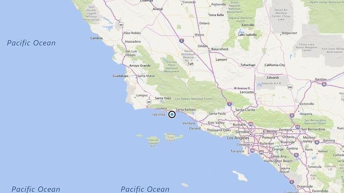
Shallow earthquake of magnitude 3.1 strikes near Santa Barbara, California

A map showing the location of the epicenter of Saturday morning's quake near Santa Barbara, Calif.
© Bing MapsA map showing the location of the epicenter of Saturday morning's quake near Santa Barbara, Calif.
A shallow magnitude 3.1 earthquake was reported Saturday morning three miles from Santa Barbara, according to the U.S. Geological Survey. The temblor occurred at 6:15 a.m. at a depth of 6.2 miles.

According to the USGS, the epicenter was five miles from Goleta, six miles from Isla Vista and 13 miles from Carpinteria.

In the last 10 days, there have been no earthquakes of magnitude 3.0 or greater centered nearby.

This information comes from the USGS Earthquake Notification Service and this post was created by an algorithm written by the author.

Seismograph

Magnitude 6.5 earthquake rattles Australia's Northern Territory and Indonesia

Banda sea quake map
© Geoscience Australia EarthquakesA map showing the earthquake off Indonesia.
A 6.5-magnitude earthquake has rattled the Northern Territory and parts of Indonesia, with residents in Darwin reporting widespread shaking but no reports of damage.

Some NT captured the shaking on video, with one clip showing a Christmas tree rocking and other showing shelves trembling.

The quake struck at a depth of 180km in the Banda Sea off the coast of eastern Indonesia about 11.17am, Geoscience Australia Earthquakes advised.

There is no tsunami threat to the Australia, the Joint Australian Tsunami Warning Centre advised.

"We're on the third floor and it gave us a shake," Darwin-based Bureau of Meteorology senior forecaster Chris Kent said, and added that the quake lasted several minutes.

Some NT residents took to Facebook to report feeling tremors.

Bizarro Earth

Earthquake faults retain a 'sense of memory'

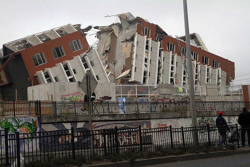
Chilean Earthquake Damage
© Creative CommonsThis 20 story building in Concepción, Chile, collapsed and fell on its back as a result of the 8.8. Richter earthquake that struck Chile on Feb. 27, 2010.
Why do earthquakes sometimes occur in clusters? This question has baffled geologists for years, but now there is an answer following a new computer model.

The computer model has been devised by researchers from Northwestern University. The model has shown that earthquake faults retain, geologically speaking, a 'sense of memory.'

According to seismologist Professor Seth Stein, in communication with Digital Journal: "if it's been a long time since a large earthquake, then, even after another quake happens, the fault's 'memory' sometimes isn't wiped out, so there's still a good chance of having another."

In these circumstances an earthquake cluster is more likely to occur and thus "earthquake clusters imply that faults have a long-term memory." This 'memory' arises as a result of an earthquake resulting in a significant strain on a fault. This means that some strain remains after a big earthquake has occurred and this can cause another earthquake to follow.

Seismograph

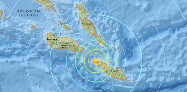
6.7 magnitude earthquake hits off Solomon Islands, no tsunami threat

The 6.7-magnitude earthquake that struck off Solomon Islands on Tuesday (Dec 20) is the second powerful tremor to hit the islands to Australia's north in two weeks
© USGSThe 6.7-magnitude earthquake that struck off Solomon Islands on Tuesday (Dec 20) is the second powerful tremor to hit the islands to Australia's north in two weeks
An earthquake with a magnitude of 6.7 struck off the Solomon Islands on Tuesday (Dec 20) according to the United States Geological Survey (USGS), the second powerful tremor in the islands to Australia's north in less than two weeks .

The Pacific Tsunami Warning Centre (PTWC) said the quake, which was centred some 120 km (70 miles) northwest of Kira Kira at a depth of s 44 km, had not triggered any tsunami threat.


Comment: See also: 6.9 magnitude earthquake strikes off Solomon Islands


Bizarro Earth

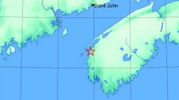
'Big boom' heard from 3.0 earthquake in southwest Nova Scotia

Digby, Nova Scotia
© Natural Resources CanadaA 3.0 magnitude earthquake was recorded about 42 kilometres soutwest of Digby on Tuesday at 10:40 a.m.
If you were in southwest Nova Scotia on Tuesday you may have felt the earth move.

At 10:40 a.m., a 3.0-magnitude earthquake was recorded about 42 kilometres southwest of Digby, according to Natural Resources Canada. The centre of the quake was about 18 kilometres below the earth's surface.

Brenda Small of Weymouth North felt it.

"I heard a very loud bang, just a big boom and then it was over," she said of the "shiver" she felt in her house.

"It wasn't anything to be a afraid of or think, 'Oh my, it's the end of the world,' nothing like that. It was just a big boom and then it was over."

Donna Gaudet was at her cousin's basement in Little Brook, N.S., a few kilometres from the epicentre, enjoying a coffee.

"We went flying up the stairs. If it wasn't an earthquake, we thought maybe a plane crashed. It was loud, it was louder than thunder," she said. "It wasn't really that exciting once the initial impact happened."
Seismograph

At least two killed by 5.8 magnitude earthquake off coast of Ecuador

Two people were killed during the earthquake
© EPATwo people were killed during the earthquake
A 5.8-magnitude earthquake has shaken Ecuador's Pacific coast early, killing at least two people, injuring 15 others and halting production at the Esmeraldas oil refinery, officials said.

The country's geological institute recorded the quake off the coast of Atacames in Esmeraldas province, northwest of Quito, the capital. The quake was followed by 15 lesser-magnitude aftershocks.

President Rafael Correa was meeting with local officials in the area, which earlier this year was devastated by a 7.8-magnitude quake that killed about 670 people, displaced thousands and caused millions of dollars in damage.

Seismograph

Shallow 4.5 magnitude earthquake recorded south of Hawaii Island

Hawaiian Volcano Observatory
© Hawaiian Volcano Observatory
An offshore magnitude-4.5 earthquake south of Hawaii Island happened at 6:30 a.m. Sunday.

The earthquake was centered about 37 miles south of Ka Lae (South Point) at a depth of 22.7 miles.

The earthquake was felt on the island, receiving over 50 reports within an hour of the earthquake. Weak shaking was reported across the island. At that intensity, damage to buildings or structures is not expected.

Sunday's earthquake occurred about 43 miles southwest of Lo'ihi, and was not caused by activity on that submarine volcano. The depth, location, and recorded seismic waves of the earthquake suggest a source due to bending of the oceanic plate from the weight of the Hawaiian island chain, a common source for earthquakes in this area. Aftershocks are possible and could be felt.

The earthquake caused no detectable changes in Kilauea Volcano's ongoing eruptions, on Mauna Loa, or at other active volcanoes on the island.

Seismograph

6.1 magnitude earthquake strikes Peru

Graph
An earthquake of 6.1 magnitude struck in Peru today near the border with Brazil but no damage was reported, the government said.

The earthquake hit 100 kilometers (60 miles) southeast of the town of Esperanza at a depth of 550 kilometers, the Geophysical Institute of Peru said.

Deeper earthquakes like this one tend to cause less damage than ones that hit closer to the surface of the earth.

Civil defense authorities said that so far no injuries or damage had been reported, the state news agency Andina said.

Esperanza, with a population of 4,500, is on the banks of the Purus River and close to the border with Brazil.

Source: Agence France-Presse

Seismograph

Magnitude 6.0 earthquake strikes off Solomon Islands

Richter magnitude scale
© AFP 2016Richter magnitude scale
The submarine earthquake took place at 05:46 GMT just 83 kilometers away from the island provincial capital of Kirakira and was at the depth of over 39 kilometers (24 miles), according to the USGS.