Earthquakes
S


Bizarro Earth

Burst of earthquakes along the Alaskan archipelago

alaska earthquake map
© USGSThis Temblor map shows the location of the earthquakes in the last two days in the Aleutian Islands. While the quakes to the northwest have strike-slip focal mechanisms, the ones to the southeast have thrust focal mechanisms.
Over the last two days, a series of earthquakes has struck the Aleutian Islands in Alaska near Adak Island. Approximately 8 hours ago, there was a M=5.9, and two days ago, a M=6.4 struck. While almost no one lives along this portion of the archipelago, the recent swarm highlights a zone where the plate boundary transitions from pure subduction to strike-slip motion. What this means is that in the area of the recent earthquakes, there is oblique subduction and earthquakes with varying focal mechanisms can occur.

Comment: See also: The Great M9.2 Alaska Earthquake and Tsunami of March 27, 1964


Bizarro Earth

The Great M9.2 Alaska Earthquake and Tsunami of March 27, 1964

1964 alaska earthquake map
© USGSMap of southern Alaska showing the epicenter of the 1964 Great Alaska Earthquake (red star).
On March 27, 1964 at 5:36pm local time (March 28 at 3:36 UTC) a great earthquake of magnitude 9.2 occurred in the Prince William Sound region of Alaska. The earthquake rupture started approximately 25 km beneath the surface, with its epicenter about 6 miles (10 km) east of the mouth of College Fiord, 56 miles (90 km) west of Valdez and 75 miles (120 km) east of Anchorage. The earthquake lasted approximately 4.5 minutes and is the most powerful recorded earthquake in U.S. history. It is also the second largest earthquake ever recorded, next to the M9.5 earthquake in Chile in 1960.

The map shows the epicenter of the 1964 Great Alaska Earthquake (red star), caused when the Pacific Plate lurched northward underneath the North American Plate.

Attention

Earthquake hits western Brittany, tremor one of several to have shaken France over weekend

Earthquakes in France
Tremor is one of several to have shaken several parts of France over the weekend

The earth moved a little bit for residents in Brittany when an earthquake struck halfway between Quimper and Vannes.

The tremor, rated at 3.2 on the Richter scale, happened 3km south-west of Quimperlé, Finistère, and 20km north-west of Lorient, Morbihan, at 15.18 yesterday and was picked up by the military detectors of the Commissariat à l'Energie Atomique.

It was reported by several residents in Quimperlé and Concarneau on social media - with one asking if it was an earthquake or a sonic boom from an aircraft. Some reported it as a shaking and others as a grinding feeling.


Brittany has been hit by several small quakes over the past few months, with the largest one being a tremor of magnitude 3.9 near Brest in December.

Seismograph

Shallow 5.9 magnitude earthquake near Tanaga Volcano, Alaska

graph
5.9 magnitude earthquake

UTC time: Wednesday, May 10, 2017 07:59 AM

USGS page: M 5.9 - 28km SW of Tanaga Volcano, Alaska

10 km depth: Andreanof Islands, Aleutian Island

Seismograph

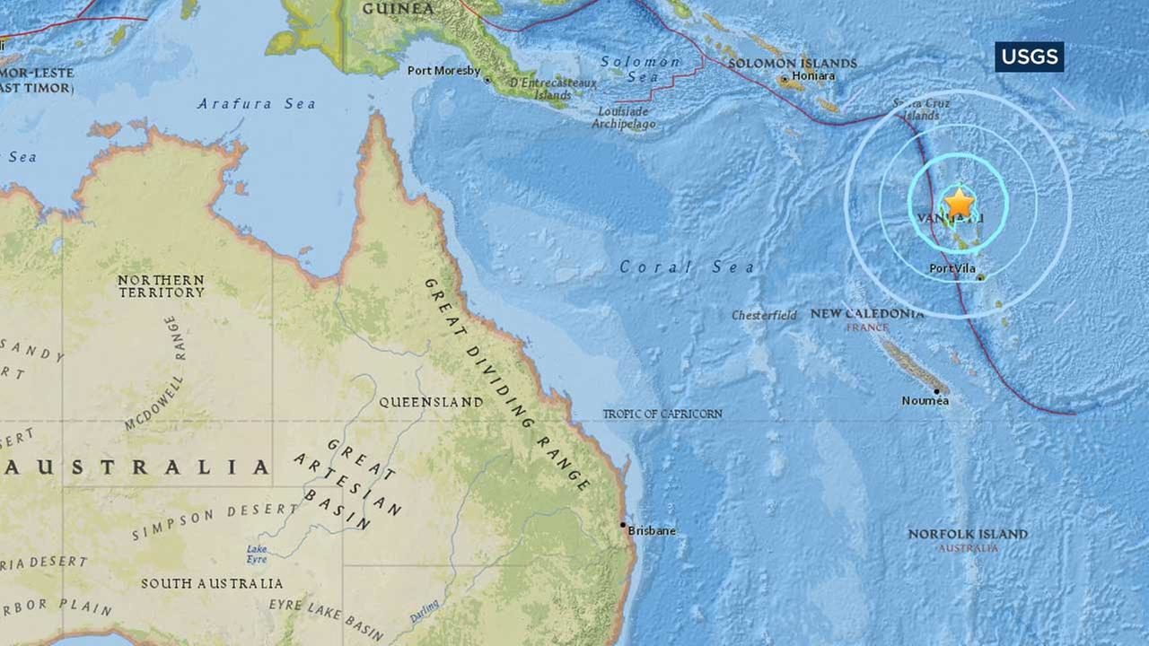
Deep 6.8 magnitude earthquake hits near Vanuatu

This map from the U.S. Geological Survey shows the location of a large earthquake that struck off the island nation of Vanuatu.
© U.S. Geological SurveyThis map from the U.S. Geological Survey shows the location of a large earthquake that struck off the island nation of Vanuatu.
An earthquake with a magnitude of 6.8 struck north of the South Pacific island nation of Vanuatu, the US Geological Survey (USGS) said.

The quake was recorded at a depth of 175km and was located about 115km north of Vanuatu's Santo island, the USGS said.

There was no immediate tsunami warning or any reports of damage or casualties.

Vanuatu had been impacted in recent days by hurricane-force winds and heavy rain from Cyclone Donna, which reached Category 5 and was the strongest cyclone ever to form in the South Pacific in the month of May.

Seismograph

Shallow 6.4 magnitude earthquake strikes off Japan's southern coast

earthquake generic
An earthquake with a preliminary magnitude of 6.4 struck off the coast of Miyakejima island in Japan''s southernmost prefecture of Okinawa on Tuesday, the weather agency here said, although no tsunami warning has been issued, China''s Xinhua news agency reported.

According to the Japan Meteorological Agency (JMA), the quake struck at 10:54 local time at a latitude of 25.2 degrees north and longitude of 126.5 degrees east. The quake originated at a depth of 10 km, the agency said.

The temblor registered 3 on Japan''s seismic scale which peaks at 7 in areas in and around Miyakejima island, and also logged 2 on the scale in areas including Tarama and Ishigaki.

The weather agency said, "Although there may be slight sea-level changes in coastal regions, this earthquake has caused no damage to Japan."

Local media or first responders in the region have yet to report any accidents or injury as a result of this offshore quake.
Bizarro Earth

Earthquake hits central Alaska, third to hit during weekend

Alaska Earthquke Center
© Alaska Earthquake CenterLocation of earthquake beneath Cook Inlet on May 6, 2017.
The Alaska Earthquake Information Center says a magnitude 3.8 earthquake hit the central part of the state.

The center says the earthquake had an epicenter 27 miles (43 kilometers) north of Pleasant Valley, a town of about 700 residents at 9:09 p.m. local time Sunday. The earthquake had a depth of 6.8 miles (11 kilometers.)

The earthquake was the fourth to hit Alaska over the weekend.

Seismograph

Shallow 4.4 magnitude earthquake hits near Mt. Hekla volcano, Iceland

graph
An earthquake of 4,4 magnitude hit South Iceland shortly after 12 noon today. Smaller quakes were also felt. The epicenter was about 30 kilometers west of the Mt. Hekla volcano and 4-7 kilometer under the earth's surface. The earthquake was felt in various parts of South Iceland including Selfoss and Hella.

According to the Icelandic Met Office the earthquakes are not related to Mt. Hekla and are not a sign that an eruption is imminent. No injuries or property damage has been reported.

Comment: A shallow earthquake of 5.8 magnitude was registered in the Scotia Sea (South Atlantic) on the same day.


Seismograph

20 small earthquakes strike near Kitsap Peninsula, Washington

graph
At least 20 small earthquakes hit near the Kitsap Peninsula in less than 24 hours, between Wednesday and Thursday.

A 3.3 magnitude was the first of the swarm, reported at 12:20 p.m. on Wednesday about 1.4 miles northeast of Bremerton.

Kitsap County dispatch said they received a couple calls about the earthquake, but there are no reports of injuries or damage at this time.

Attention

Shallow 5.8 magnitude earthquake recorded near Karakenja, Tajikistan; followed by 3 aftershocks

graph
5.8 magnitude earthquake 27 km from Karakenja, Tajikistan

2017-05-05 05:09:35 UTC

UTC time: Friday, May 05, 2017 05:09 AM

Reports from the public: 14 people

USGS page: M 5.8 - 27km NNW of Karakenja, Tajikistan

10 km depth

Comment: Just 2 days ago: Shallow magnitude 5.9 earthquake strikes Tajikistan