Earthquakes
S


Bizarro Earth

Magnitude 6.2 earthquake - 39km S of Namatanai, Papua New Guinea

Papua NG
© USGS
Magnitude: 6.2

Location uncertainty: 4.022°S 152.489°E± 8.7 km

Depth Uncertainty: 10.0 km± 1.7

Origin Time: 2017-05-15 13:22:38.580 UTC

Seismograph

New research finds mega-quakes can cause Earth's crust to rip open and snap shut

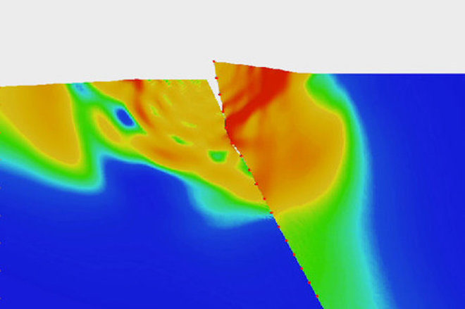
Thrust fault computer model
© Harsha BhatThis illustration, based on computer models, shows how the hanging wall (right) of a thrust fault can twist away from the foot wall (left) during an earthquake.
Like a crocodile's jaw opening and snapping shut, Earth's crust can rip apart and then violently close back up during an earthquake, a new study finds.The discovery refutes previous claims that this kind of phenomenon was impossible, and the new research could potentially require that current seismic maps be redrawn.

The study focused on a particular paradox associated with thrust faults, a crack in Earth's crust, where geologic forces are slowly pushing a huge slab of continental crust up and over an oceanic layer.

"For a long time, it was assumed that thrust faults, subduction zone faults being a class of such faults, could not have a large amount of slip close to the Earth's surface," said Harsha Bhat, a research scientist at the École Normale Supérieure (ENS) in Paris and co-author of the new study with California Institute of Technology graduate student Vahe Gabuchian.

A dormant hypothesis

The assumption was made because as the continental slab grinds over the oceanic one below, it scrapes off the soft surface clay and leaves it piled up in the subduction zone. Geologists thought that any energy generated from a seismic event within the thrust fault would peter out once it hit the soft clay and that a large slip wouldn't happen near the surface.

Seismograph

Shallow 5.7 earthquake hits northeastern Iran; 3 killed, hundreds injured

graph
At least three people were killed and 225 injured in a 5.7-magnitude earthquake that hit North Khorasan Province of Iran on Saturday night, semi-official ISNA news agency reported on Sunday.

With a depth of 11 km, the earthquake's epicenter was at 37.655 degrees north latitude and 57.224 degrees east longitude. It hit Pish Qaleh region in North Khorasan Province at 22:30 local time (1800 GMT) on Saturday, Iran Seismological Center said.

Medical services along with disaster relief forces have been dispatched to the hit area from neighboring cities and a crisis management base has also been set up, Mohammad Reza Salehi, the governor of North Khorasan Province, told ISNA.

According to the latest reports, up to 40 percent of power, communication, gas and water services of the affected areas have been disrupted.


Attention

3,000 Alaska earthquakes already this month; 'marked increase' say seismologists

earthquake in Whitehorse, Alaska
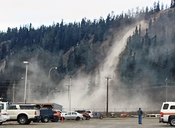
© Angie Dickson / via Yukon NewsDirt rolls down the clay cliffs across from Canadian Tire during a May 1, 2017 earthquake in Whitehorse.
A series of significant May earthquakes and their aftershocks are being examined by seismologists, who say Alaska is markedly above its usual rate of earthquakes for the month.

Alaska Earthquake Center seismologist Natalia Ruppert said Alaska typically experiences a "background level" of 35,000 earthquakes each year, plus any significant earthquakes and their aftershocks. The center typically sees about 3,000 quakes statewide in a month — but May has been well ahead of that pace, Ruppert said.

"Right now, with the aftershocks, we recorded close to the monthly average in just the first 10 days," Ruppert said.

The catalog of May temblors as of Wednesday included at least three larger than a 6, seven larger than a 5 and 50 larger than a 4 on the Richter scale, according to an overview compiled by the earthquake center's Ian Dickson.

The month began with a 6.2 quake and a 6.3 aftershock on May 1 under the Haines Highway in Canada that rattled much of Southcentral Alaska, causing significant damage in the Canadian city of Whitehorse. State seismologist Michael West said the quake struck along the Denali fault line, which extends from Southeast Alaska through Canada into the Alaska Range.

More than 800 aftershocks had been detected from the Southeast quake by Wednesday, Dickson wrote. The state also saw a 5.2 quake 10 miles north of Ninilchik on May 6 that was felt in Valdez and Palmer, as well as a 3.8 the following day northeast of the Fort Knox gold mine that was felt in Fairbanks.
Bizarro Earth

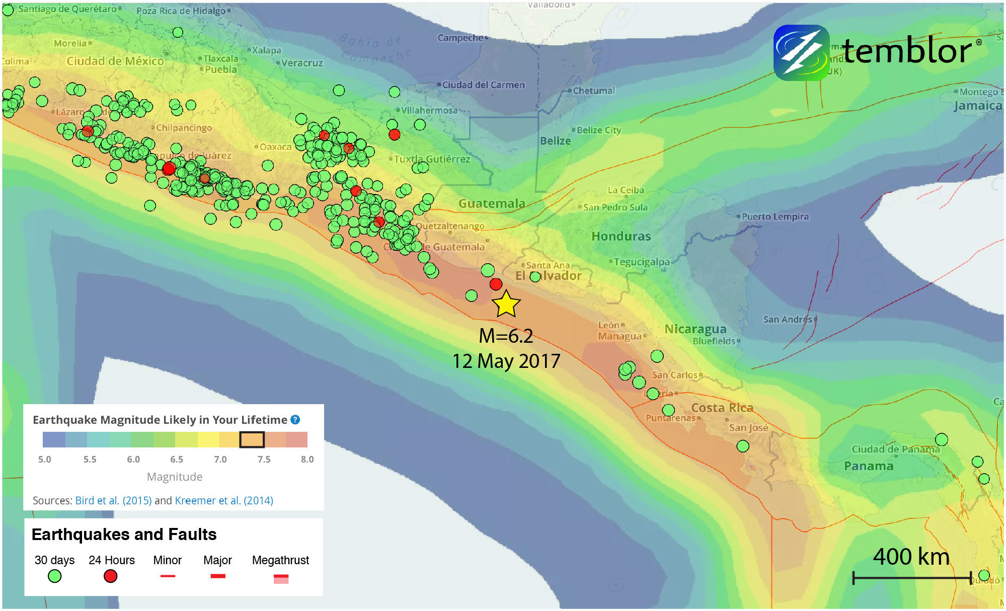
Magnitude 6.2 subduction zone earthquake strikes El Salvador

el salvador earthquake map
© TemblorThis Temblor map shows the location of today’s M=6.2 earthquake, as well as Global Earthquake Activity Rate (GEAR) model.
A M=6.2 earthquake struck off the coast of El Salvador at 4:41 a.m. local time this morning (12 May 2017). According to the USGS, the quake occurred at a depth of 10 km, approximately 75 km offshore. So far, no reports of damage have come in, and the USGS estimates that economic losses should remain minimal, and that there should be no fatalities as only light shaking was felt in the country, including in the capital city of San Salvador, which is home to over 250,000 people.

Even though the USGS does not have a focal mechanism, based on the earthquake's depth and location, it likely occurred on the Central American subduction zone or just above it. This analysis was also aided by using the Slab 1.0 model by Gavin Hayes at the USGS (which appears in Temblor as "Megathrust" zones). This model is a compilation of global subduction zones geometries. Based on the geometry of this subducting slab, it should be at a depth of 10-20 km in the location of today's event.

USGS data

Seismograph

Shallow 6.2-magnitude quake registered off the coast of El Salvador

graph
The U.S. Geological Survey says a strong earthquake has struck off the coast of El Salvador.

The quake, with a preliminary magnitude of 6.2, struck at around 4:40 a.m. Friday morning. Its depth was measured at a shallow 10 kilometers (6 miles). It was followed by at least one large aftershock.

The epicenter was about 60 miles (97 kilometers) from the city of Sonsonate, and 79 miles (128 kilometers) from the capital, San Salvador.

There were no immediate reports of damage.

Source: AP

Attention

Small earthquake shakes Seattle area days after swarm near Kitsap Peninsula

Kitsap earthquake map
After more than a dozen earthquakes, including two early Thursday, struck around the Kitsap Peninsula since early May, another small temblor off Whidbey Island shook the Seattle area

After two earthquakes early Thursday, part of a swarm of minor quakes that have struck the Kitsap Peninsula, another earthquake was detected at 10:56 a.m. off Whidbey Island.

The first quake hit at 12:34 a.m. Thursday, with a magnitude of 3.6 and an epicenter 3.4 miles from Bremerton, according to the University of Washington's Pacific Northwest Seismic Network (PNSN). More than 700 people reported to the U.S. Geological Survey (USGS) that they felt some intensity of shaking in places from Vashon Island to Bellevue to Lynnwood.

The second, smaller temblor came at 2:36 a.m., with a magnitude of 2.6 and an epicenter 2.1 miles from Bremerton.

Comment: 20 small earthquakes strike near Kitsap Peninsula, Washington


Bizarro Earth

Earthquake magnitude 5.4 along the Tashkurgan Fault takes lives in western China

village of Kuziguncun,
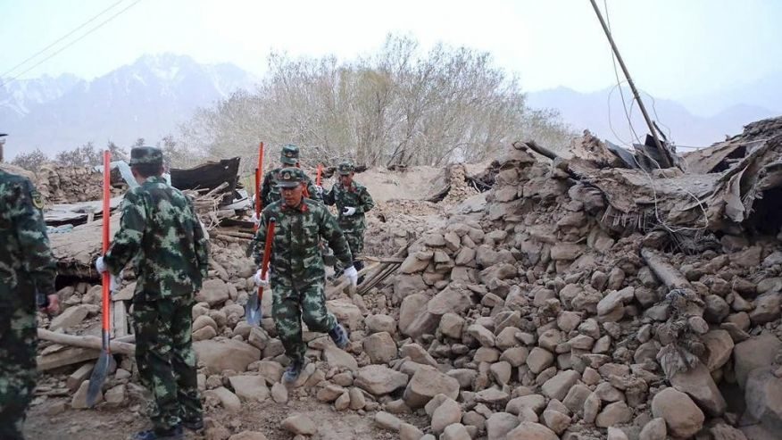
© Li Jing/Xinhua via APIn the village of Kuziguncun, 3 km north of the epicenter of today’s earthquake, many buildings collapsed. What is evident from this picture is that poor build quality was a major factor in why there was so much damage in a M=5.4 quake.
A M=5.4 earthquake at 5:58 a.m. local time (11 May 2017) struck western China's Taxkorgan county, along the border with Tajikistan. The earthquake collapsed 180 buildings and homes, and killing at least eight people, and injuring 23. According to the USGS, severe shaking was felt close to the epicenter, in what is a mountainous, sparsely populated region of China. This shallow (10 km) earthquake was primarily a normal faulting (extensional) event, though there was a very small component of strike-slip movement. But due to the remoteness of this quake, reports are still coming in as search and rescue continues.

Despite the small size and modest shaking of the M=5.4 mainshock, the poor building quality in the region meant structures were susceptible to collapse, especially close to the epicenter (see picture below). In this portion of western (Xinjiang) China, the majority of homes are made of wood, mud bricks, or rock. This illustrates how important construction quality is to earthquake resilience. Here, buildings were reduced to rubble, resulting in fatalities.

Seismograph

Shallow magnitude 6.8 quake hits off South Sandwich Islands

world map
A magnitude 6.8 quake hit off South Sandwich Islands, a British overseas territory in the southern Atlantic near Antarctica.

The earthquake was registered at 23:23 UTC at the depth of 6.2 miles. There was no tsunami warning.
#Earthquake M6.4 South Sandwich Islands Region 8mins ago 10 May 23:23 UTC — report/info: https://t.co/i4HI40Ex5U

— Earthquake Monitor (@EQAlerts) May 10, 2017

Seismograph

At least 8 killed after shallow M5.4 earthquake damages 180+ houses in northwest China

China earthquake map May 11 2017
© Google Maps
A moderate, shallow earthquake in northwest China has claimed the lives of at least eight people and injured dozens more after almost 200 homes in the area reportedly collapsed.

At least 8 people were killed and over 20 injured after a 5.4-magnitude earthquake struck Taxkorgan County in northwest China's Xinjiang Uygur Autonomous Region at 5:58am Thursday, the region's earthquake administration said.

The quake, in a remote mountainous area that borders Tajikistan, Afghanistan and Pakistan, struck at a depth of 10 kilometers, the US Geological Survey said.

The shallow quake, known to cause greater shaking at the surface inflicted a lot of damage.

More than 180 houses collapsed and 789 people were affected, the Xinjiang Uyghur seismological center announced.