Earthquakes
S


Bizarro Earth

Earthquake Magnitude 6.2 - 88km WNW of Skagway, Alaska

alaska
© USGS

Magnitude
6.2 mww

Location uncertainty 59.844°N 136.695°W± 4.4 km

Depth uncertainty 2.2 km± 3.3Origin

Time 2017-05-01 12:31:54.500 UTC

USGS Data

Comment: See also: Shallow 6.3 magnitude earthquake 90 km from Haines, Alaska; second strong quake within 2 hours for the region


Seismograph

Shallow 5.7 magnitude earthquake registered off Kagoshima, Japan

chart
5.7 magnitude earthquake 42 km from Nishinoomote, Kagoshima, Japan
2017-04-29 12:32:32 UTC

UTC time: Saturday, April 29, 2017 12:32 PM
Your time: 2017-04-29T12:32:32Z
Magnitude Type: mww
USGS page: M 5.7 - 42km ENE of Nishinoomote, Japan
USGS status: Reviewed by a seismologist
Reports from the public: 5 people

2017-04-29 12:32:32 UTC 5.7 magnitude, 21 km depth
Nishinoomote, Kagoshima, Japan

Seismograph

Shallow 5.6 magnitude earthquake recorded off East Java, Indonesia

chart

5.6 magnitude earthquake 170 km from Boyolangu, East Java, Indonesia

2017-04-29 10:02:12 UTC

UTC time: Saturday, April 29, 2017 10:02 AM
Your time: 2017-04-29T10:02:12Z
Magnitude Type: mww
USGS page: M 5.6 - 152km SSW of Tambakrejo, Indonesia
USGS status: Reviewed by a seismologist
Reports from the public: 0 people

Seismograph

6.8 quake strikes off Philippines triggers tsunami warning

Philippines earthquake
© USGS
A 6.8 earthquake has struck south off the island of Mindanao, triggering a warning of "hazardous tsunami waves" for the coastline of islands in the Philippines, according to the US Geological Survey and the Pacific Tsunami Warning Center.

The Pacific Tsunami Warning Center said that tsunami waves could reach 300km from the epicenter of the earthquake, which was recorded at 6.8 on the Richter scale.

Waves reaching up to 1 meter above normal tide levels are possible in the Philippines, while some coastlines in Indonesia, Malaysia and Palau could expect waves up to 30 centimeters higher than usual, the Pacific Tsunami Warning Center said.

Bizarro Earth

Chile rattled by more than a dozen off-shore earthquakes

Chile
More than a dozen moderate earthquakes have rattled the Chilean coast within just over two hours, the most powerful of them registered at magnitude 5.9.

The continued rattling prompted some cities to suspend classes and give workers the afternoon off. There are no reports of damage or injury.

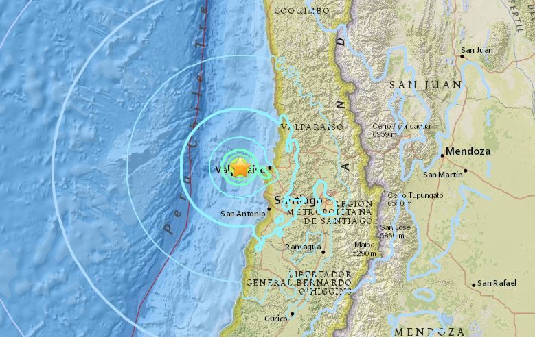
The U.S. Geological Survey says the strongest hit at 12:30 p.m. (1530 GMT). That magnitude 5.9 shake was centred about 26 miles (41.5 kilometres) southwest of Valparaiso and about 65 miles (110 kilometres) west of the capital, Santiago.

It was followed within about two hours by 15 other quakes of magnitude 3.8 to 5.7, centred in the same region.

A magnitude 6.9 quake shook the same general region on Monday.

Comment: Shallow 5.7 magnitude earthquake rattles Chile


Seismograph

Shallow 5.7 magnitude earthquake rattles Chile

chart
A 5.7 magnitude earthquake rattled buildings in the Chilean capital Santiago on Friday, the most powerful in a string of tremors that struck central Chile during the afternoon.

The United States Geological Survey said the tremor at around 1:05 p.m. local time (1605 GMT) was magnitude 5.7, with a depth of 9 miles ( 14 km) and an epicenter 12 miles (20 km) west of the coastal town of Valparaiso.

No damage was reported by the emergency office and the navy said the quake had not been severe enough to cause a tsunami.

The area has been shaken by dozens of quakes over the last week, including a 6.9 magnitude tremor on Monday, which caused no serious damage.

Seismograph

Shallow 5.7 magnitude earthquake recorded in the Aleutian Islands, Alaska; 4 aftershocks follow

chart
5.7 magnitude earthquake

2017-04-27 14:46:33 UTC

UTC time: Thursday, April 27, 2017 14:46 PM
USGS page: M 5.7 - 77km S of Little Sitkin Island, Alaska

Better Earth

New map shows the world hidden beneath your feet

Mount Saint Helens
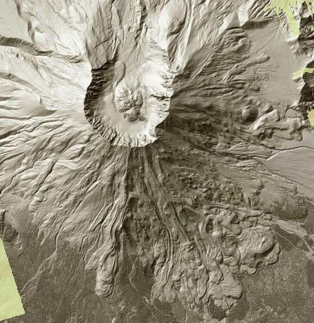
© Sailor, Craig - Tacoma Department of Natural ResourcesMount Saint Helens can be seen in this screen grab from the Washington State Department of Natural Resources’ Lidar map. The 1980 eruption blew out the northern side, top, of the volcano, while the southern side shows volcanic flows from ancient eruptions.
Puget Sound is grooved like an old record. That's one of the Earth's secrets that can be found on a new interactive map produced by the state.

Using Lidar technology, the Washington State Department of Natural Resources has mapped a good third of the state revealing the smallest of details hidden beneath trees, buildings and other obstructions.

The grooves, carved by ancient glaciers, can be seen from Whidbey Island to south of Olympia. Tacoma is etched with a series of subtle pattern of north-south lines. The grooves become most prominent around Lake Tapps.

Toggling between "Bare Earth" and "Top Surface" is the best way to view the map.

Bizarro Earth

Shallow magnitude 7.1 earthquake strikes off Chile's coast

earthquake image
Magnitude 7.1

Location uncertainty 33.056°S 72.042°W± 4.2 km

Depth uncertainty 10.0 km± 1.9Origin

Time 2017-04-24 21:38:25.080 UTC

USGS data


Comment: A shallow magnitude 5.9 earthquake struck in the same region a few days ago.


Seismograph

Shallow magnitude 5.9 earthquake hits off Chile coast

Chile earthquake 23/04/17
© USGS
A magnitude 5.9 earthquake rocked central Chile late Saturday, monitors said, though there were no immediate reports of injuries or damage.

The tremor took place at 11.36 pm (0236 GMT), centered off the coast at 42 kilometers (26 miles) west of Valparaiso, according to the US Geological Survey.

It had a depth of 9.8 kilometers.

Chile's National Emergency Office, or ONEMI, estimated its strength at 6.1 on the Richter scale.

The Navy's hydrographic and oceanographic service found that the quake "has the characteristics to generate a tsunami".

However, no warning was issued by the Hawaii-based Pacific Tsunami Warning Center.

A series of smaller earthquakes in Valparaiso in the evening hours rattled locals.