Earthquakes
S


Attention

Oklahoma, Kansas, Texas rattled by strong back-to-back earthquakes

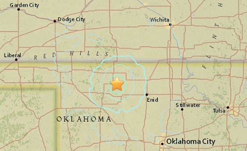
Oklahoma earthquakes map
© USGSA map shows the epicenter of a 4.8-magnitude earthquake that occurred Wednesday, Jan. 6, 2016, which was felt in Oklahoma, Kansas and Texas.
Two strong earthquakes rocked Oklahoma, Kansas and Texas on Wednesday night.

The quakes were recorded as magnitudes 4.7 and 4.8, respectively, the United States Geological Survey reported.

The larger temblor was centered 19 miles south-southeast of Alva, Oklahoma, west of Enid, at 10:28 p.m. CST, the USGS said. The first quake occurred 30 seconds before the larger quake near Fairview, Oklahoma.

Both were felt in Wichita, Kansas, where meteorologists from AccuWeather Enterprise Solutions were working.

"The tables shook pretty good as well as our computer screens. Really felt like the whole building was rumbling. We are on the seventh floor so it always seems like it's worse up here," Lead Meteorologist John Lavin said.

The quakes were one of six earthquakes to be reported within 90 minutes Wednesday night in Oklahoma, according to USGS data.
Comment: See also: There is growing evidence that fracking and earthquakes are linked:


Attention

Series of earthquakes hit Siargao Island town in the Philippines

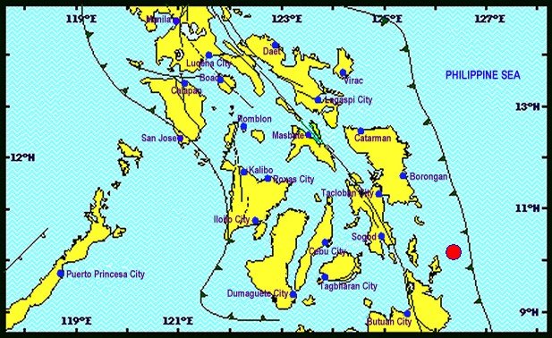
Epicenter map of 5.2 earthquake
© PhivolcsEpicenter map of 5.2 earthquake
A series of earthquakes rattled Siargao Island town, in Surigao del Norte early this morning, January 6, 2015.

The Philippine Institute of Volcanology and Seismology (Phivolcs) said the strong earthquake with 5.2 magnitude quake was registered at 4:36 a.m. Its epicenter was plotted at 32 kilometers (km) northeast of Burgos town, Siargao Island, Surigao del Norte, with a depth of 12 km.

A magnitude 4.2 magnitude tremor also recorded at 4:31 a.m. of the same day, with epicenter traced at 56 km northeast at the same town, with a depth of 13 km, the state agency said.

Another 3.0 magnitude earthquake was also registered at 5:31 a.m. also on the same day and same town of Burgos with the epicenter 48 km northeast, with a depth of 88 kilometers, Phivolcs, in its bulletin said.

The series of earthquakes that rocked the island town are all tectonic in origin, it said.

The action center of the Provincial Disaster Risk Reduction and Management Council (PDRRMC) in Surigao del Norte said there were no casualties or damages reported when the earthquake hit the tourist island.

Attention

5.0 magnitude earthquake hits Trinidad

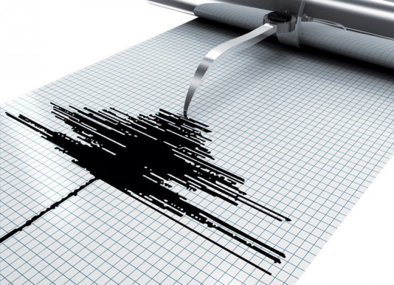
Earthquake graph
© Science Photo Library
Trinidad and Tobago and Grenada registered a 5.0 magnitude earthquake yesterday and the experts are warning of more to come.

According to the University of the West Indies Seismic Research Centre, the earthquake occurred at 10:33 a.m. North of the Paria Peninsula Trinidad, at a depth of 33 kilometres.

"This zone is one of the most active areas around Trinidad so that this event is not surprising and well within our range of expected activity", according to a statement from the SRC.

Director of the SRC, Dr Joan Latchman said Tuesday's quake was not generated by the Kick'em Jenny underwater volcano located eight kilometres north of Grenada.

She said the earthquake is one of many expected to occur during the year.

Bizarro Earth

Earthquake recorded near North Korean nuclear site

North Korean Quake
© USGS
A 5.1 magnitude earthquake has been recorded in North Korea, according to USGS, in the vicinity of a known nuclear site. South Korea has convened an emergency meeting over fears of a possible nuclear test.


Comment: North Korea claims fully successful 'hydrogen bomb' test


Attention

34 earthquakes recorded in 2015 for Jammu and Kashmir, India

Earthquake graph
© Science Photo Library
Govt "ill-prepared" to deal with disasters

Jammu and Kashmir has recorded 34 earth quakes in 2015 which has brought to limelight the state"s vulnerabilities to natural disasters.

According to the Indian metrological department, most parts of Kashmir covering the districts of Srinagar, Ganderbal, Baramulla, Kupwara, Bandipora, Budgam, Anantnag and parts of Jammu region, Doda, Ramban, Kishtwar come under Seismic Zone V and are prone to earthquakes. While the rest part of the state comes under Seismic Zone IV.

In 2015, the frequent earth quakes some were measured above 7 magnitude on the Richter scale has proved that J&K is prone to earthquakes and there is a dire need of having well equipped agencies to deal with natural disasters.

According to the official figures of J&K meteorological department, 34 earthquakes hit J&K in 2015. Tremors were felt twice in February last while eight earth quakes were reported in March. Tremors jolted the state four times in April including a powerful earth quake on April 25 measuring 7.5 on the Richter scale. Tremors were felt twice and once in the month of May and June respectively. In July, the state recorded four earthquakes although of low intensity. Mild to moderate tremors were felt twice and thrice in the month of August and September respectively. In October, two earth quakes were recorded including a powerful one on October 26 of 7.5 magnitude in which three people lost their lives and caused damage to scores of houses across the state. The figures reveal, earth quakes were recorded thrice in the month of November. In December also, tremors jolted J&K thrice including a power earthquake on 26 midnight of the month measuring 6.5 on the Richter scale in which two people died due to heart attack.

Comment: See also: 4,300 earthquakes strike Indonesia in 2015

Seismic activity increases in Azerbaijan: 7,000 earthquakes in 2015


Attention

Hundreds more earthquakes shake Oklahoma in 2015 setting new state record

Earthquake reader
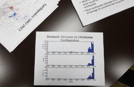
Earthquakes in Oklahoma spiked in 2015, jumping more than 50 percent and setting another state record, according to Energy Wire.

The state was rocked by 881 earthquakes with a magnitude of 3 or greater last year, compared to 578 in 2014, according to data from the Oklahoma Geological Survey.

Quakes have been on the rise in Oklahoma following a boom in oil and gas activity — state officials have blamed the seismic activity on an increase in wastewater injections in drilling areas.

The technique that has helped Oklahoma become a bigger energy producer, hydraulic fracturing, involves blasting a combination of water, chemicals and sand underground to unlock the oil and natural gas trapped in shale deposits. When the left over water from that process is pumped into some fault lines, state researchers have said, an increase in seismic activity can result. The Oklahoma Corporation Commission requires well operators to prove that their wells do not reach a certain depth that has been linked to greater earthquake activity, according to The Oklahoman.

Pages from a powerpoint presentation
© Sue Ogrocki / APPages from a powerpoint presentation discussing the recent earthquake activity in Oklahoma are pictured at the Oklahoma Geological Survey at the University of Oklahoma in Norman, Okla., Thursday, June 26, 2014. Earthquakes that have shaken Oklahoma communities in recent months have damaged homes, alarmed residents and prompted lawmakers and regulators to investigate what's behind the temblors and what can be done to stop them.

Comment: See also: 17,500 earthquakes recorded for Nevada in 2015


Attention

'Horrible rumble' from 3.5 earthquake in Custer County, Nebraska

Earthquake reader
Rumbling through the Sandhills, an earthquake rattled folks across Custer County on Monday. That includes Shannon Cooksley, who was in her kitchen writing checks.

She said, "All of a sudden there was a shaking and a horrible rumble."

The Cooksley's picturesque Sandhills ranch was near the epicenter of an earthquake, with a magnitude of 3.5.

Cooksley said, "People in Broken Bow didn't know what was going on. I heard reports on the radio that maybe a plane had crashed at the airport or maybe a train had derailed."

Shannon and her husband Kevin Cooksley have seen a lot, as Kevin told NTV in July 2014.

"Weathering drought and natural disasters," he said.

But an earthquake is a first for their ranch, and their recently remodeled home a carpenter said was well-built, like a barn.

Shannon said, "To make it shake, it had to be fairly strong, or fairly close anyway."

Attention

5.1 earthquake hits Banda sea in Indonesia

Banda sea
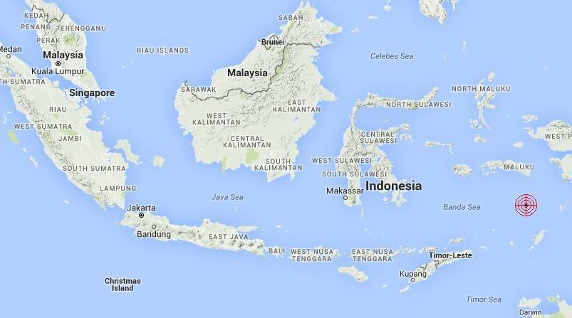
© Malaysian Meteorological Department.The moderate earthquake took place at 1:28pm,6.3S 130.6E with Magnitude 5.1 and Depth 231km at Banda Sea.393km Southeast of Ambon,Indonesia.1794km Southeast of Semporna,Sabah.
A moderate earthquake, measuring 5.1 on the Richter scale, occurred in the Banda Sea in Indonesia at 1.28pm today (Jan 5), according to the Meteorological Department.

It said in a statement that the epicentre of the quake was 393km southeast of Ambon, Indonesia, and 1,794km southeast of Semporna, Sabah.

The quake did not pose any tsunami threat, it added.

Attention

4.2 magnitude tremor shakes Marlborough, New Zealand

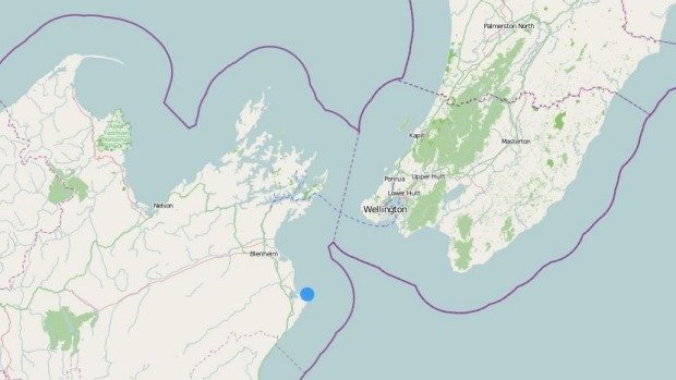
earthquake 15km east of Seddon
© GeonetAn earthquake 15km east of Seddon
An earthquake has struck east of Seddon.

The 4.2 magnitude tremor, just after 9am on Tuesday, was centred 15 kilometres east of Seddon at a depth of 37km, according to GeoNet.

It was felt widely across Marlborough and also in Nelson and Christchurch.

Facebook user Alysha Morgan, who lives in Seddon, said she ran for the door frame after the quake.

"Was quite violent here," Morgan said.

Attention

4.5 earthquake recorded in Limassol, Cyprus

Earthquake reader
An earthquake measuring 4.5 was recorded in the Limassol area on Tuesday morning, the Geological Survey Department said.

The epicentre of the earthquake was the sea area 50 km southwest of Limassol at a depth of 30 km.

The quake was recorded at 9.17 am. It lasted about five seconds with furniture and lighting shaking, according to a resident of Ypsonas, which is located 53 km northeast of the epicentre.

"The quake was rather short. It lasted only a couple of seconds. It was intense though; more of an up and down shake," a resident of Erimi near Limassol commented on twitter.