Earthquakes
S


Attention

Magnitude 4.3 earthquake under the Strait of Georgia, Canada

Map BC
© USGS
A modest magnitude 4.3 earthquake was felt in Metro Vancouver late this evening at 11:40 p.m.

According to the federal government's Natural Resources Canada department, the earthquake had a deep depth of 58.7 kilometres and an epicentre 19 kilometres northeast of Victoria and eight kilometres east-southeast of Sidney - right under the Strait of Georgia. It was also felt strongly on Vancouver Island and elsewhere on the B.C. South Coast.

The seismic event was originally classified as a magnitude 4.9 event by the U.S. Geological Survey, but it was downgraded shortly after.

There are no reports of any significant damage at this time. As well, no tsunami alert has been issued - a tsunami is not expected given the magnitude and location.


Attention

Papua New Guinea shaken by 5.6 magnitude earthquake

Graph
A 5.6-magnitude earthquake struck Papua New Guinea, the US Geological Survey said Tuesday.

The quake was registered at 01:51 GMT.

The epicenter was located about 92 kilometers (57 miles) south of the town of Panguna at the depth of 47.2 kilometers.

There are currently no reports of damage or victims due to the earthquake.

Attention

4.8 magnitude earthquake strikes offshore of Northern California, near Eureka

Eureka earthquake map
A magnitude-4.8 quake struck off the coast of California, near Eureka on Monday

An earthquake with a magnitude of 4.8 struck off California, 64 miles northwest of Eureka, on Monday night, according to the U.S. Geological Survey. The USGS initially measured the quake at magnitude-4.5.

The earthquake struck at 7:35 p.m. local time.

The National Oceanic Atmospheric Administration said there was no tsunami threat to Hawaii or the West Coast, following the temblor.

For more info on this quake and others, visit the SFGATE earthquake page here.

Arrow Down

4.2 magnitude earthquake hits near Barstow, California

Earthquake
A preliminary magnitude-4.2 earthquake that struck 26 miles north-northwest of Barstow, in the Mojave Desert area, was reportedly felt by some in Los Angeles Sunday morning.

The quake hit around 10:31 a.m. with a depth of .4 miles, the U.S. Geological Service reported.

It was located 23 miles east-southeast of Johannesburg, 36 miles southeast of Ridgecrest and 62 miles northeast of Lancaster.

Multiple KTLA viewers and several tweets indicated people felt it in the Hollywood, Northridge and Pasadena areas.

There were no immediate reports of damage.

Info

The worst earthquake in recent European history that struck Sicily in 1908

 Sicily earthquake 1908
Sicily earthquake 1908
Completely flattening the cities of Messina in Sicily and Reggio di Calabria on the Italian mainland, the most devastating earthquake in recorded European history struck on 28th December, 1908.

The horrifying earthquake started at around 5am in the Straits of Messina. It is estimated that the earthquake and ensuing Tsunami killed between 100,000 and 200,000 people. Along with the two cities devastated by the quake, dozens of smaller coastal towns were also severely damaged.

Measuring 7.5 on the Richter Scale, the main shock of the earthquake triggered a 40 foot high tsunami which smashed coastal towns on both Sicily and the Italian mainland.

In the days following the 28th December hundreds of smaller tremors exacerbated the situation, causing more damage and severely hampering relief efforts to the worst affected areas.

Comment: See also: 'This Gulf of Fire': The cataclysmic earthquake that leveled Lisbon


Attention

4,300 earthquakes strike Indonesia in 2015

Earthquake graph
At least 4,300 earthquakes measuring more than 3 in Richter scale happened in Indonesia in 2015, according to a report. As many as 360 earthquakes among them were felt and 7 of them were destructive.

A seismologist from the Bandung Institute of Technology Irwan Meilano said that on average, in Indonesia, earthquakes happened every day.

Irwan also said that the data was taken from the Meteorology, Climatology and Geophysics Agency (BMKG).

"Ironically, almost all destructive earthquake happen in areas not included in the earthquake map," Irwan said on Sunday (27/12).

Comment: See also this report from another part of the world: Seismic activity increases in Azerbaijan: 7,000 earthquakes in 2015


Attention

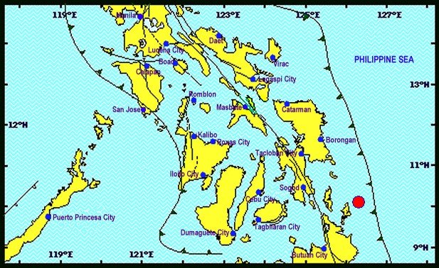
5.2 earthquake shakes Siargao Island, Philippines

Map Philippines
© PhivolcsA 5.2 magnitude earthquake was recorded at 6:11 a.m., Sunday, with its epicenter traced at 29 km northeast of San Isidro town, Siargao Island, Surigao del Norte.
A 5.2 magnitude earthquake rattled Siargao Island residents including vacationing tourists, particularly villagers residing along the islands' coastal areas facing the Pacific Ocean, Sunday morning.

The strong quake occurred at 6:11 a.m. with its epicenter traced at 29 kilometers (km) northeast of San Isidro town, Siargao Island, Surigao del Norte, the Philippine Institute of Volcanology and Seismology (Phivolcs), said in its bulletin.

The tremor was tectonic in origin, with a depth of 51 km. The quake was also felt in the cities of Surigao and Butuan.

It was caused by movements along a local fault in Surigao Island, Phivolcs said.

No aftershock was registered and no tsunami alert was raised by the state agency.

Arrow Down

Indonesia's Maluku province jolted by 5.9-magnitude earthquake

Earthquake
An earthquake measuring 5.9 on the Richter Scale rocked Indonesia's Maluku province on Friday, the Meteorology and Geophysics Agency said.

The earthquake occurred at 6.11 a.m. (local time) and had its epicentre 242 km northwest of Maluku Tenggara Barat with a depth of 117 km under the sea bed, an official told Xinhua.

No casualties were reported.

Indonesia is prone to earthquakes as it lies on the vulnerable "Pacific Ring of Fire".

Attention

6.2-magnitude earthquake rattles northern Afghanistan; tremors felt in Pakistan, India

Earthquake Afghanistan
© USGS
A 6.2 magnitude quake has hit northern Afghanistan, the US geological survey (USGS) reports. Strong jolts have been felt in neighboring Pakistan and northern India, according to reports on social media.

The epicenter fell 81km southeast of the Afghan city of Feyzabad, according to US seismological monitors.

Tremors were felt in the Afghan capital, Kabul, Pakistan's capital, Islamabad, and in India's capital, New Delhi.

No casualties have been reported.


Attention

Over 30 earthquakes rattle area around Reno, Nevada

earthquake needle
A series of more than 30 earthquakes that rattled the Reno area over the past two days occurred on the most significant fault structure in the area, and scientists are monitoring for potentially bigger shock waves to follow, experts said Wednesday.

The quakes began Tuesday evening and continued into Wednesday morning. The largest — a magnitude-4.4. late Tuesday — shook homes and businesses in a 300-square-mile area near the Nevada-California line.

No significant damage was reported.

Graham Kent, director of the Nevada Seismological Lab at the University of Nevada, Reno, was at home when the biggest quake hit and described it as "quite a jolt."