Earthquakes
S


Attention

6.0 magnitude earthquake off the coast of Aisen, Chile

Graph
© Dimas Ardian, Getty Images
6.0 magnitude earthquake

2016-07-27 01:25:12 UTC

UTC time: Wednesday, July 27, 2016 01:25 AM

Your time: 2016-07-27T01:25:12Z

Magnitude Type: mwc

USGS page: M 6.0 - Off the coast of Aisen, Chile

USGS status: Reviewed by a seismologist

Reports from the public: 1 person

Alarm Clock

USGS: Strong 6.3 magnitude earthquake hits off Papua New Guinea

Papua New Guinea earthquake map
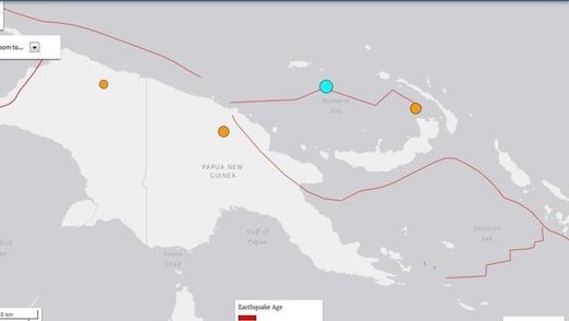
© USGSA map of Papua New Guinea showing the epicentre of the quake (blue) that hit the island nation on Tuesday, 26 July 2016.
A strong 6.3-magnitude earthquake struck off Papua New Guinea in the Admiralty Islands area early today, US geologists said, but no destructive Pacific-wide tsunami is expected.

The offshore quake hit at 5.38am (local time) and occurred 128km southeast of Lorengau, Papua New Guinea, according to the US Geological Survey (USGS).

The epicentre was at a depth of 6.6km.

No damage or injuries were immediately reported. The Hawaii-based Pacific Tsunami Warning Centre assured that there was no threat of a widespread tsunami.

Quakes are common for the island nation that lies on the 4,000km-long Pacific Australia plate, which forms part of the "Ring of Fire", a hotspot for seismic activity due to friction between tectonic plates.

Attention

Magnitude 6.2 earthquake hits north-central Chile

Chile earthquake
© USGS26.106°S 70.646°W - 68.5 km depth
A 6.2-magnitude earthquake has struck Chile's north-central region but authorities say no injuries or damage were reported and discounted the possibility of a tsunami.

The U.S. Geological Survey said the quake's epicenter was 41 miles west-northwest of Diego de Almagro, Chile and struck Monday at 1:26 p.m. local time.

Chile's emergency services office says no damage to infrastructure was immediately reported and there are no indications of casualties. The navy says no tsunami alert has been issued.

The South American country is highly earthquake-prone. A devastating 8.8-magnitude quake in 2010 and the tsunami it unleashed killed more than 500 people and destroyed 220,000 homes.


Attention

4 earthquakes strike Hawaii; 3 in the area of Kilauea Volcano

Graph
© Dimas Ardian, Getty Images
Four earthquakes hit Hawaii island on Friday and late Thursday, three in the area of Kilauea Volcano.

A fourth quake, at magnitude-4.3, struck the island at 9:16 p.m. Friday. The epicenter was 1.9 miles west-southwest of Honalo, a bit north of Kealakekua Bay, at a depth of 7 miles.

The first, with a magnitude of 2.5, hit 3.7 miles southwest of Volcano at a depth of 1.9 miles. It happened at 5:30 p.m. Thursday.

The second, magnitude-2.7, had an epicenter 9 miles southeast of Volcano. It struck at 11:18 a.m. Friday at a depth of 3.3 miles.

The third, magnitude-3, struck at 12:14 p.m. 6 miles southeast of Leilani Estates, in the ocean south of Cape Kumukahi. The depth of the epicenter was 20 miles.

Attention

6.1 earthquake strikes off southern Australia

EARTHQUAKE MAP
A 6.1 magnitude earthquake has struck near Australia, according to Geoscience Australia.
Mag 6.1 Western Indian Antarctic Ridge, 25 July 2016, 18:58 (AEST). Lat/Long 49.36S, 126.0E. Depth 15km. Info is preliminary.
— EarthquakesGA (@EarthquakesGA) July 25, 2016
It was previously reported that the earthquake was "potentially tsunamigenic," meaning it could cause a tsunami. However, that information has since been retracted.

The US Geological Survey (USGS) has put the quake at a 5.9, with a depth of 10km (6.2 miles).

Bizarro Earth

2nd earthquake in 3 days rattles parts of North Carolina

North Carolina eartquakes
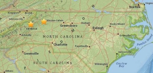
The location of the earthquakes on a map from the US Geological Survey. The one on the left (furthest west) happened Thursday, while the other quake hit Saturday night.
An earthquake shook parts of North Carolina near the Virginia border in Wilkes County on Saturday night.

The 2.4 magnitude quake hit around 9:50 p.m. and was at a depth of 5.1 kilometers, according to the US Geological Survey.

The quake on Saturday night happened just two days after 1.9 magnitude earthquake struck Thursday at Plumtree, N.C. in Avery County — about 60 miles west-southwest of the Saturday quake.

The Saturday night quake was right along US 421 and was closest to Millers Creek, N.C. — which was 3 miles from the center.

There were no reports of damage.

The quake was also about 4 miles west of Wilkesboro and north of W. Kerr Scott Lake.

Map

String of earthquakes hits Kyrgyzstan

kygyzstan
© File photo
An earthquake occurred today in Alay district, Osh region of Kyrgyzstan. Press service of the Ministry of Emergency Situations reported.

According to it, the seismic station of the Institute of Seismology of the National Academy of Sciences of Kyrgyzstan registered tremors with the force of 3 points in the epicenter at 6.26 a.m. The focus was located on the border of Kyrgyzstan and Tajikistan, on Trans Alai ridge. No injuries or damage were recorded.

As noted, this is the second consecutive earthquake in the area. On July 20 at 6.55 p.m. there have been tremors with the force of 3.5 points in the epicenter. No victims and destruction were also recorded.

Comment: Yesterday too, a magnitude 4.3 hit the country. Last month, a 6.4 hit Kyrgyzstan, and in December of last year, a 7.2. This comes a week after Merkel's visit to the Central Asian nation, and the same day that the exhibition-fair making its way through the Silk Road countries. On the border, Tajikistan just arrested 2 individuals attempting to join Daesh, and Russia's military base has been put on high alert.


Attention

Newly discovered giant megathrust fault has potential to kill millions

megathrust fault
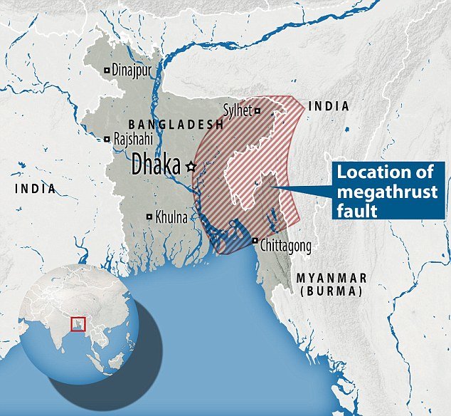
More than 140 million people live within a 60 mile area of the potential disaster zone in Bangladesh.
A giant fault in the earth's crust covers by millions of tonnes of sediment in one of the world's most densely populated areas could kill tens of millions of people, scientists have claimed.

Researchers placed hundreds of highly accurate GPS receivers in locations across India, Bangladesh and Myanmar and monitored them over a ten year period.

Now the scientists fear the location is home to a megathrust fault which could unleash a 9.0 magnitude earthquake at any minute.

The scientists, led by Dr Michael Steckler from Columbia University published their findings in the journal Nature.

The experts discovered that millions of tonnes of sediment from the Ganges and Brahmaputra rivers has been dumped into the megathrust fault, where one of the earth's plates is being pushed under another.

Target

South Bay earthquake swarm continues near Hollister, California

Hollister swarm
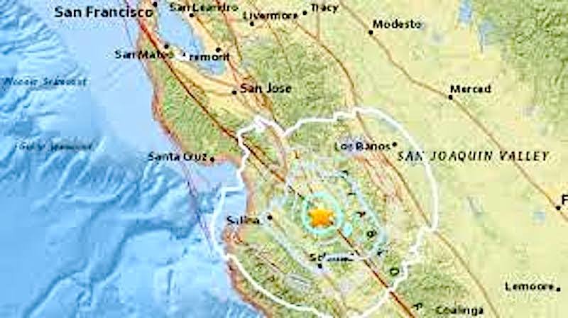
© sanfrancisco.cbslocal.comSan Andreas Fault, latest swarm of quakes.
An earthquake swarm is continuing to rattle the South Bay near Hollister. In the past four days, more than 39 tremors have hit the area on a section of the San Andreas system known as the Calaveras Fault. Between Sunday night and Monday afternoon, 39 quakes greater than 1.0 have occurred and 20 more than 2.0, seven over 3.0, one 4.1 and one 4.2, according to the U.S. Geological Survey.

The first struck Sunday night at 10:26 a.m., 12 miles southeast of Hollister, and had a preliminary magnitude of 3.3. Over 260 people reported the incident to the USGS. The largest quake recorded on Monday gave a gentle shake at 2:27 a.m., 12 miles northeast of Hollister, and had a preliminary magnitude of 3.8.


Several quakes shook the area on Tuesday, including a 4.2 trembler recorded 11 miles southeast of Hollister and 17 miles east of Salinas. Over 650 people reported feeling this quake. On Wednesday, tremors continued to gently shake the area, and the USGS recorded two 3.0 earthquakes. One hit 12 miles southeast of Hollister at 5:14 a.m. and another two miles southwest of San Juan Bautista and nine miles west of Hollister at 7:08 a.m.

No injuries or damage have been reported.
Attention

Magnitude 6.0 earthquake hits off Vanuatu

Graph
© Dimas Ardian, Getty Images
6.0 magnitude earthquake 76 km from Isangel, Tafea, Vanuatu

2016-07-20 15:13:16 UTC

UTC time: Wednesday, July 20, 2016 15:13 PM

Your time: 2016-07-20T15:13:16Z

Magnitude Type: mwb

USGS page: M 6.0 - 76km NNW of Isangel, Vanuatu

USGS status: Reviewed by a seismologist

Reports from the public: 1 person