Earthquakes
S


Alarm Clock

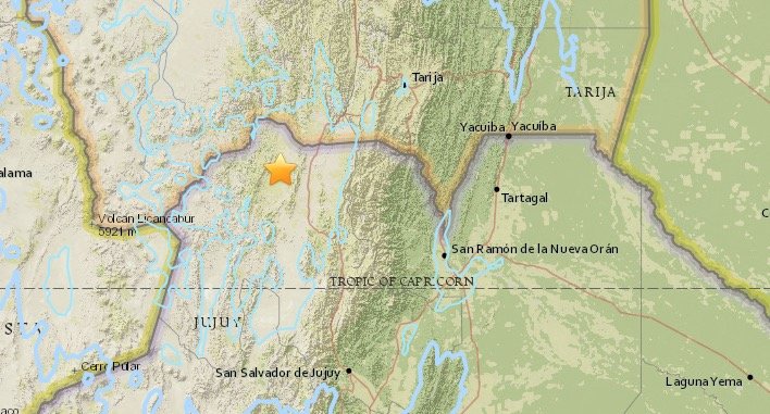
Magnitude 6.1 earthquake hits south west of La Quiaca, Argentina

Argentina earthquake
© USGS
Preliminary Earthquake Report

Magnitude: 6.1

Date-Time:
  • 4 Aug 2016 14:15:11 UTC
  • 4 Aug 2016 11:15:11 near epicenter
  • 4 Aug 2016 09:15:11 standard time in your timezone
Location: 22.385S 65.994W

Depth: 258 km

Distances:
  • 48 km (29 mi) NW of Abra Pampa, Argentina
  • 51 km (31 mi) SW of La Quiaca, Argentina
  • 52 km (32 mi) SW of Villazon, Bolivia
  • 107 km (66 mi) SSW of Tupiza, Bolivia
  • 689 km (427 mi) SSE of La Paz, Bolivia

Attention

Series of earthquakes rattle Northern California

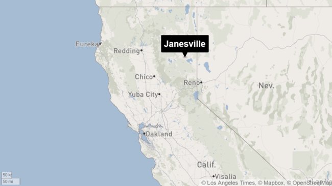
Janesville, California
© Los Angeles Times
A cluster of moderate earthquakes rocked Northern California on Wednesday night and early Thursday morning.

About 9:55 p.m. Wednesday, a magnitude 4.5 earthquake was reported about 20 miles east of Janesville, near the Nevada border, according to the U.S. Geological Survey.

Within minutes, two more magnitude 4.4 quakes were reported around the same area in Lassen County, according to the USGS. The epicenters were about 45 miles north of Reno and 10 miles south of Honey Lake, the USGS said.

Early Thursday morning, a magnitude 3.4 earthquake was reported 19 miles from Janesville, according to the USGS. The temblor occurred at 3:13 a.m. at a depth of 3.1 miles.

The shake map compiled by the USGS showed that the quakes were felt in Susanville and Reno.

It's unclear whether the quakes caused any damage.

Comment: Series of 70 small earthquakes in California: Big one coming?


Attention

6.1 magnitude earthquake recorded in Mid Indian Ridge

Graph
© Dimas Ardian, Getty Images
6.1 magnitude earthquake

2016-08-01 07:42:50 UTC

UTC time: Monday, August 01, 2016 07:42 AM

Your time: 2016-08-01T07:42:50Z

Magnitude Type: mb

USGS page: M 6.1 - South Indian Ocean

USGS status: Reviewed by a seismologist

Reports from the public: 0 people

Attention

Shallow 5.4 magnitude earthquake jolts SW China

China earthquake
© Weibo.comAn earthquake hits southwest China's Guangxi Zhuang Autonomous Region on July 31, 2016.
An earthquake measuring around 5.4 on the Richter scale hit Cangwu County, Wuzhou City in south China's Guangxi Zhuang Autonomous Region at 5:18 p.m. on Sunday.

The epicenter was monitored at 24.08 degrees north latitude and 111.56 degrees east longitude, with a depth of 10 kilometers, according to the China Earthquake Networks Center (CENC).

The center initially said it was a 5.1-magnitude quake based on preliminary measurement.

The tremor, which was felt in multiple cities in Guangxi and in neighboring Guangdong Province, damaged some houses in two townships close to the epicenter, but no casualties have been reported, according to the local government.

Several trains were halted in the region to ensure safety, according to the Nanning Railway Bureau.


Attention

Shallow magnitude 5.2 earthquake strikes off Crete, Greece

MAP GREECE
A magnitude 5.2 earthquake struck off the coast of Crete in Greece on Saturday the United States Geological Survey reported.

The quake's epicenter was located 63 miles (100 km) west southwest of Chania, Crete. It was very shallow, with a depth of 5.6 miles (9 km).

Source: Reuters

Bizarro Earth

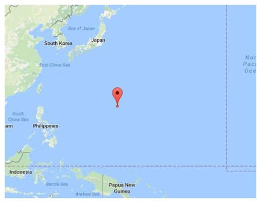
7.7 magnitude earthquake strikes in the Northern Mariana Islands

Earthquake Northern Mariana Islands
© Google Maps
A powerful but deep earthquake with a preliminary magnitude of 7.7 has struck the U.S. commonwealth the Northern Mariana Islands in the western Pacific Ocean, seismologists say. No tsunami warnings have been issued.

The earthquake, which struck at 7:18 a.m. local time on Saturday, was centered about 32 kilometers (19 miles) southeast of the island of Agrihan, or 364 kilometers (226 miles) north of Saipan, which is the largest island of the Northern Mariana Islands.

The Pacific Tsunami Warning Center measured the preliminary magnitude of the earthquake at 7.7 but said it struck at a depth of 203 kilometers (126 miles), which will significantly minimize its effects. The earthquake was widely felt in both the Northern Mariana Islands as well as the U.S. territory of Guam.

"Based on all available data, there is no tsunami threat because the earthquake is located too deep inside the Earth," the tsunami warning center said in a bulletin. Chile's Hydrographical and Oceanographical Service of the Navy (SHOA) briefly issued a tsunami warning but canceled it just minutes later.

In October 2007, a powerful 7.2-magnitude earthquake was centered about 58 miles (93 kilometers) north-northwest of Pagan in the Northern Mariana Islands. It struck about 154.3 miles (248.3 kilometers) deep, making it a deep earthquake, and there were no reports of damage or casualties.
X

Norseman, Australia: The town that won't stop trembling - 33 quakes in 30 days

Norseman, Australia
© Don Pugh/FlickrNorseman, a gold-mining town 720km east of Perth, WA, currently holds the title of the shakiest place in Australia.
With three 5.0 magnitude earthquakes in two months, this is the most tottery town in Australia.

The Western Australian town of Norseman has a serious case of the shakes - with a staggering 50 earthquakes hitting the area in the last two months. The gold-mining town - located about 720km east of Perth - has had over 30 quakes this month, with 18 alone on 8 and 9 July.

It all began after a 5.0 magnitude earthquake shook the town in the middle of the night on 28 May, followed by an even stronger 5.1 magnitude aftershock about an hour later.

John Fry, works manager at the Dundas Shire, said he heard a loud rumbling, and soon after, got a call from the Department of Fire and Emergency Services, checking if the town needed assistance. "I thought it was just a train coming through," he said. "The last thing you think of is an earthquake."

Attention

6.0 magnitude earthquake off the coast of Aisen, Chile

Graph
© Dimas Ardian, Getty Images
6.0 magnitude earthquake

2016-07-27 01:25:12 UTC

UTC time: Wednesday, July 27, 2016 01:25 AM

Your time: 2016-07-27T01:25:12Z

Magnitude Type: mwc

USGS page: M 6.0 - Off the coast of Aisen, Chile

USGS status: Reviewed by a seismologist

Reports from the public: 1 person

Alarm Clock

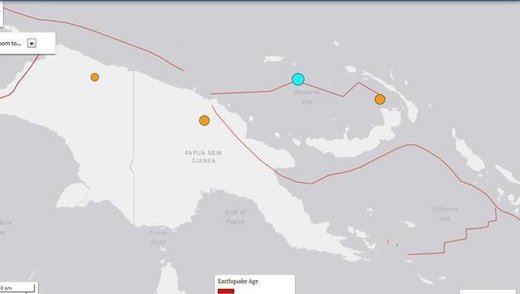
USGS: Strong 6.3 magnitude earthquake hits off Papua New Guinea

Papua New Guinea earthquake map
© USGSA map of Papua New Guinea showing the epicentre of the quake (blue) that hit the island nation on Tuesday, 26 July 2016.
A strong 6.3-magnitude earthquake struck off Papua New Guinea in the Admiralty Islands area early today, US geologists said, but no destructive Pacific-wide tsunami is expected.

The offshore quake hit at 5.38am (local time) and occurred 128km southeast of Lorengau, Papua New Guinea, according to the US Geological Survey (USGS).

The epicentre was at a depth of 6.6km.

No damage or injuries were immediately reported. The Hawaii-based Pacific Tsunami Warning Centre assured that there was no threat of a widespread tsunami.

Quakes are common for the island nation that lies on the 4,000km-long Pacific Australia plate, which forms part of the "Ring of Fire", a hotspot for seismic activity due to friction between tectonic plates.

Attention

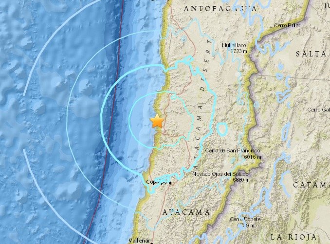
Magnitude 6.2 earthquake hits north-central Chile

Chile earthquake
© USGS26.106°S 70.646°W - 68.5 km depth
A 6.2-magnitude earthquake has struck Chile's north-central region but authorities say no injuries or damage were reported and discounted the possibility of a tsunami.

The U.S. Geological Survey said the quake's epicenter was 41 miles west-northwest of Diego de Almagro, Chile and struck Monday at 1:26 p.m. local time.

Chile's emergency services office says no damage to infrastructure was immediately reported and there are no indications of casualties. The navy says no tsunami alert has been issued.

The South American country is highly earthquake-prone. A devastating 8.8-magnitude quake in 2010 and the tsunami it unleashed killed more than 500 people and destroyed 220,000 homes.