Earthquakes
S


Attention

Strong 5.7 magnitude earthquake hits near Pinotepa Nacional, Mexico

Map Mexico
© Google
A strongly earthquake with a preliminary magnitude of 5.7 has struck near the city of Pinotepa Nacional in the southwestern state of Oaxaca, with shaking felt as far away as Mexico City, seismologists and residents say.

The earthquake, which struck at 3:50 p.m. local time on Monday, was centered about 20 kilometers southeast of Pinotepa Nacional, according to Mexico's seismological agency SSN. It said the earthquake struck at a shallow depth of 20 kilometers.

SSN initially measured Monday's earthquake at 6.0 before downgrading it to 5.4, but the U.S. Seismological Agency put the magnitude at 5.7.

Details about damage or casualties were not immediately available, but the tremors were felt as far away as Mexico City, where buildings shook and some were evacuated. Because the earthquake struck on land, there is no threat of a tsunami.

Mexico sits on the so-called 'Pacific Ring of Fire', an arc of fault lines circling the Pacific Basin which is prone to frequent and large earthquakes. In late March, a powerful 7.4-magnitude earthquake struck southwestern Mexico, killing at least two people and injuring 11 others.

Bizarro Earth

South Kyrgyzstan struck by strong 6.3-magnitude earthquake

Kyrgyzstan earthquake
© USGS
A strong 6.3-magnitude earthquake struck southern Kyrgyzstan on Sunday, the European Mediterranean Seismological Centre (EMSC) said.

The quake was registered at 11:17 GMT at the depth of 12 miles. It hit some 75 miles southeast from the Central Asian nation's second largest city of Osh, with a population of 200,000.

Tremors were felt wide across the region, with shocks reaching nearby Kazakhstan, a RIA Novosti correspondent in the Kazakh city Almaty said.

There were no immediate reports of casualties or damage from Kyrgyzstan's Emergencies Ministry.

Bizarro Earth

Earthquake magnitude 5.9 strikes off the coast of Japan

Earthquake in Japan
© Sputnik News
Moscow - A 5.9-magnitude earthquake has occurred off the coast of Japan, the US Geological Survey (USGS) reports. The earthquake struck at around 21:05 GMT on Thursday, about 102 kilometers (63 miles) southeast of Yonaguni, the westernmost inhabited island of Japan.

The epicenter was located at a depth of around 10 kilometers (6.2 miles), USGS said.

In April, a magnitude 6.5 earthquake struck to the east of Kumamoto city (the capital of Kumamoto Prefecture) on Japan's Kyushu Island.

It was followed by multiple aftershocks, including a 7.0-magnitude earthquake. Over 40 people were killed as a result of the natural disaster and more than 2,000 people were injured.

Japan is a seismically active region. In March 2011, a 9.0-magnitude offshore earthquake triggered a 46-foot tsunami that hit Japan's Fukushima nuclear power, leading to the leakage of radioactive materials and the shutdown of the plant. The accident is considered to be the world's worst nuclear disaster since Chernobyl.

Attention

Silent 'slow slip' earthquake detected off Gisborne, New Zealand

silent earthquake plotted
© GeoNetA silent earthquake's movement is plotted
A 'silent' earthquake that's been happening for a week, and could continue for months, has been detected off the coast of Gisborne.

GeoNet said today that the event, which could move faults at the equivalent of magnitude 5 or higher regular earthquakes, had just been detected and was being monitored.

The slow-motion earthquakes, also known as "slow slips", are undetectable by humans or seismographs, and are instead measured using changes in distance between global positioning system stations across the North Island.

They have been shown to be able to trigger - or alleviate - large, tsunami-generating earthquakes.


Follow slow-slip motion on GeoNet

The agency said a magnitude 4 earthquake off the coast of Gisborne last week was likely related.

The phenomenon is fairly new to science and, after being discovered in the United States, was first located in New Zealand in the early 2000s.

Bizarro Earth

Study predicts probability of magnitude 9+ earthquake in Aleutian Islands which could send mega-tsunami toward Hawaii

aleutian islands
© UPI Photo/Jeff Williams/NASA The Aleutian Islands sit atop a hotspot of volcanic and tectonic activity, and scientists predict a nine percent chance of a mega-earthquake in the next 50 years.
There's a nine percent chance a magnitude 9 or larger earthquake will strike the Aleutian Islands in the next 50 years. That is the prediction offered by scientists from the University of Hawai'i at Mānoa -- made with the help of a newly designed computer model.

Researchers say an earthquake of that size could send a mega-tsunami in the direction of the Hawaiian Islands.

The Aleutian Islands, which stretch toward Russia from the coast of Alaska, sit along a subduction zone at the convergence of the Pacific and North American tectonic plates. Scientists say the chance of a dramatic slip along the fault lines that make up the subduction zone is significant.

They detailed the threat of a mega-earthquake in a new paper, published this week in the Journal of Geophysical Research - Solid Earth.

"Necessity is the mother of invention," lead study author Rhett Butler, a geophysicist at the UHM School of Ocean and Earth Science and Technology, explained in a news release. "Having no recorded history of mega tsunamis in Hawai'i, and given the tsunami threat to Hawai'i, we devised a model for Magnitude 9 earthquake rates following upon the insightful work of David Burbidge and others."

Comment: Further reading: Multiple recent powerful earthquakes reflect a planet in deep transition


Boat

USGS: Magnitude 6.1 earthquake hits Northern Mid-Atlantic Ridge

Location
Earthquake Mid-Atlantic Ridge
© USGS22.661°N 45.133°W depth=10.0 km (6.2 mi)
Time
  1. 2016-06-21 16:26:34 (UTC)
  2. 2016-06-21 12:26:34 (UTC-04:00) in your timezone
  3. Times in other timezones
Nearby Places
  • 1813.0 km (1126.5 mi) ENE of Grande Anse, Guadeloupe
  • 1835.0 km (1140.2 mi) ENE of Saint-Francois, Guadeloupe
  • 1838.0 km (1142.1 mi) ENE of Le Moule, Guadeloupe
  • 1847.0 km (1147.7 mi) ENE of Sainte-Anne, Guadeloupe
  • 1853.0 km (1151.4 mi) ENE of Saint John's, Antigua and Barbuda

Attention

Magnitude 6.1 earthquake recorded near Namatanai, Papua New Guinea

Graph
© Dimas Ardian, Getty Images
An earthquake with preliminary magnitude of 6.1 has been recorded near Namatanai, Papua New Guinea on 21 June 2016 12:12:09.

The earthquake epicenter was located at precisely 67km WNW of Namatanai, Papua New Guinea and at a depth of approximately 366.37 km.

A provisional tsunami alert have been issued for the region following this earthquake.

Other details about the earthquake were not immediately available, and there were no immediate reports of damage or casualties.

Attention

New areas of motion detected near California's San Andreas Fault System

Statistical model
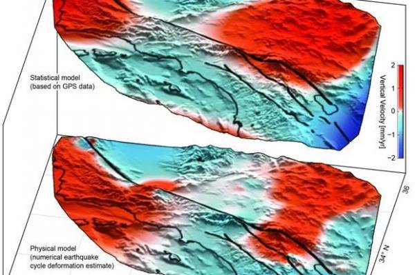
© University of Hawaii, ManoaThe top diagram shows the lobes of movement, uplift in red and subsidence in blue, found using GPS data, while the bottom diagram shows the lobes predicted by an earthquake simulation model.
Analysis of GPS data has revealed new areas of motion around the San Andreas Fault System.

Using data collected by the EarthScope Plate Boundary Observatory's GPS array, researchers identified 125-mile-wide "lobes" of uplift and subsidence. Over the last several years, the lobes, which straddle the fault line, have hosted a few millimeters of annual movement.

Computer models simulating the San Andreas Fault System have predicted such crustal movement, but the areas of motion hadn't been physically identified until now. Researchers used advanced statistical modeling to identify the movement among the inevitable statistical noise that comes with monitoring minute movements in the Earth's crust.

"While the San Andreas GPS data has been publicly available for more than a decade, the vertical component of the measurements had largely been ignored in tectonic investigations because of difficulties in interpreting the noisy data," lead author Samuel Howell, a researcher at the University of Hawaii at Manoa, explained in a news release. "Using this technique, we were able to break down the noisy signals to isolate a simple vertical motion pattern that curiously straddled the San Andreas fault."
Comment: California: San Andreas fault 'locked, loaded and ready to roll' with big earthquake, expert says


Bizarro Earth

Earthquake hotspot: 'Large scale motion' detected along San Andreas fault

Los Angeles
© Lucy Nicholson / Reuters
Large scale motion has been detected along the San Andreas Fault line, thanks to new analysis of existing data that could help predict 'The Big One' in the future.

Previously uninterpreted data showing vertical movement of the fault's crust detected several millimeters of uplift and subsidence in surface areas as large as 125 miles.

While these hotspots were predicted in models before, this is the first time scientists were able to block out white noise and other diluting factors such as precipitation and local surface geology.

Bizarro Earth

M6.3 earthquake 112km south of Isangel, Vanuatu

Earthquake map
© USGS
Large earthquake strikes south of Vanuatu. No tsunami alert has been issued.

Time: 2016-06-19 05:47:22 UTC-04:00
Location: 20.564°S 169.321°E
Depth: 13.6 km