Earthquakes
S


Bizarro Earth

Magnitude 6.3 undersea earthquake strikes off Indonesian coast

Earthquake off Indonesian Coast
© USGS
The U.S. Geological Survey says a 6.3 magnitude undersea earthquake has struck off Indonesia's eastern coast.

The quake struck at 19:15 GMT Tuesday, 126 kilometers (80 miles) west northwest of Kota Ternate, Indonesia at a depth of 38.3 kilometers (24 miles), the USGS said.

There were no immediate reports of casualties or damage from the quake and no tsunami warning was issued.

Indonesia is prone to earthquakes due to its location on the Pacific "Ring of Fire," an arc of volcanoes and fault lines in the Pacific Basin. In December 2004, a massive earthquake off Sumatra island triggered a tsunami that killed 230,000 people in a dozen countries.

Source: Associated Press

Attention

6.2 magnitude earthquake near Jalisco, Mexico

 quake
© El Comercio/AP
6.2 magnitude earthquake 92 km from San Patricio, Jalisco, Mexico

UTC time: Tuesday, June 07, 2016 10:51 AM

Your time: Tuesday, June 7 2016 11:51 AM

Magnitude Type: mwp

USGS page: M 6.2 - 102km SSW of San Patricio, Mexico

USGS status: Reviewed by a seismologist

Reports from the public: 0 people

Arrow Up

Strong 6.0 magnitude earthquake hits off New Zealand

New Zealand earthquake
© USGSA map showing the location of a strong magnitude-6 earthquake northeast of New Zealand on June 6 2016.
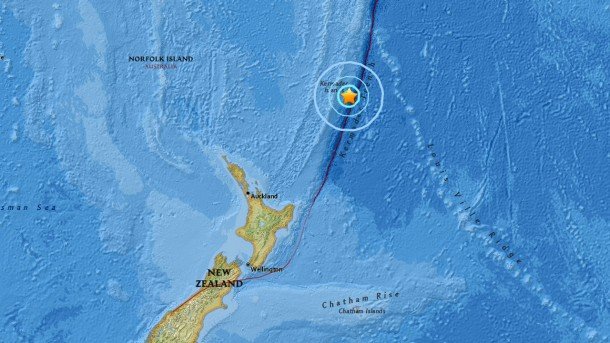
A strong 6.0-magnitude struck Monday almost 90 miles off a remote New Zealand island, the US Geological Survey reported.

The shallow quake occurred at the depth of 6.2 miles southeast of the Kermadec Islands in the South Pacific.

No information about the damage or casualties was immediately available.

Parts of New Zealand lie on the so-called Ring of Fire, a horseshoe-shaped string of volcanoes around the Pacific Rim, where about 90 percent of the world's quakes occur.

Bizarro Earth

A 6.3-magnitude earthquake hits Indonesia

Leksula Earthquake
© USGS
A 6.3-magnitude earthquake occurred in Indonesia, the US Geological Survey (USGS) said on Sunday.

The epicenter of the quake was located 132 kilometers (82 miles) southwest of the city Leksula, at a depth of 428 kilometers (266 miles), according to the agency.

There have been neither immediate reports of damages or casualties,. nor a tsunami threat.

Indonesia is located in the so-called Ring of Fire quake zone, where a large number of earthquakes and volcanic eruptions occur. Earlier this week, a strong 6.5 earthquake occurred in South Sumatra, a province on the island of Sumatra in Indonesia.

Bizarro Earth

Magma buildup in northern New Zealand explains spate of recent earthquakes, may signal beginning of new volcano

Taupo volcanic zone new zealand
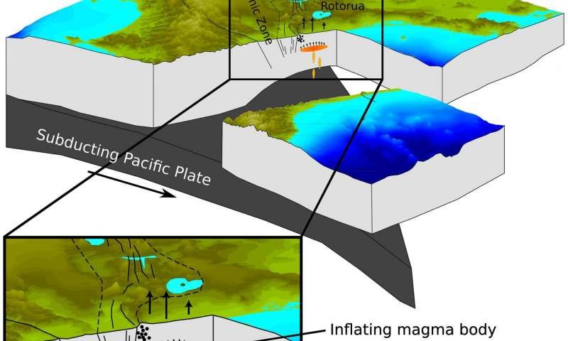
© Ian Hamling A drawing looking south along the Taupo Volcanic Zone showing the subduction of the Pacific Plate under the North Island of New Zealand. Uplift of the surface measured by satellite radar and GPS suggests the presence of a magmatic body beneath the Bay of Plenty coast at a depth of 9.5 km
Scientists say they've discovered a magma buildup near a New Zealand town that explains a spate of recent earthquakes and could signal the beginnings of a new volcano—although they're not expecting an eruption anytime soon.

Geophysicist Ian Hamling said that since 1950, enough magma to fill 80,000 Olympic-size swimming pools has squeezed up beneath the surface near the coastal town of Matata, about 200 kilometers (120 miles) southeast of Auckland.

A paper published Saturday in the online journal Science Advances outlines the findings. Hamling, the paper's lead author, said that while other parts of New Zealand have active volcanoes, there have been none near Matata for at least 400,000 years.

"It was quite a big surprise," he said in an interview with The Associated Press.

Using GPS data and satellite images, the scientists say they discovered an area of land about 400 square kilometers (154 square miles) has risen by 40 centimeters (16 inches) since 1950.

Hamling said a period of quick uplift between 2004 and 2011 likely triggered thousands of small earthquakes. Scientists had previously thought tectonic shifts caused the quakes.
Bizarro Earth

Strong 6.5 quake strikes off Indonesia's coast

Sumatra map earthquake
© earthquake.usgs.gov
A powerful 6.5 earthquake hit the western Indonesian island of Sumatra on Thursday. The epicenter of the quake was about 40km (25 miles) from the coast, according to the US Geological Survey.

Earthquake depth was 50.8 km.

Attention

Panic as 3 earthquakes hit Umbria, Italy

 quake
© El Comercio/AP
An earthquake measuring 4.1 on the Richter scale struck the central Italian region of Umbria on Monday night, and was followed by two smaller quakes this morning, creating panic among residents and closing schools in the hilltop town of Orvieto.

The first quake, which was also felt in Tuscany and Lazio, was registered by the National Institute of Geophysics just before 10.30pm.

The epicentre was in the town of Castel Giorgio at a depth of 14.8km.

Nobody was injured and there were no reports of damage to property.

But strong tremors could be felt in Perugia, Trasimeno and Orvieto, as well as the Tuscan provinces of Arezzo and Grosseto.

Bizarro Earth

Magnitude 6.1 earthquake strikes Northern Taiwan

Taiwan Earthquake
© Anadolu Agency
An earthquake with a preliminary magnitude of 6.1 shook parts of northern Taiwan on Tuesday afternoon.

The U.S. Geological Survey recorded the temblor as striking 114 kilometers (70.8 miles) northeast of capital Taipei at sea at a depth of 242.9 kilometers at 1.23 p.m. (0523GMT).

According to Taiwan's official Central News Agency, no casualties or damage were reported immediately.

The territory's Central Weather Bureau measured the earthquake as having a magnitude of 7.2 and being felt most intensely in Yilan County and parts of Hualien County.

In February, a magnitude 6.4 temblor left 117 people dead and more than 500 injured, the majority of whom had been inside a high-rise residential building that collapsed in the southwestern city of Tainan.

Attention

Magnitude 5.7 earthquake hits near Raoul Island, New Zealand

 quake
© El Comercio/AP
An earthquake with preliminary magnitude of 5.7 has been recorded near Raoul Island, New Zealand on 30 May 2016 02:14:16.

The earthquake epicenter was located at precisely 123km S of Raoul Island, New Zealand and at a depth of approximately 32.18 km. No tsunami alert have been issued following this earthquake.

Other details about the earthquake were not immediately available, and there were no immediate reports of damage or casualties. We will update this report as soon as we have more information.

Attention

5.3 magnitude earthquake injures 28 people in Algeria

 quake
© El Comercio/AP
At least 28 people were injured; including three who were left in a serious condition following a 5.3 magnitude earthquake that hit Algeria's province of Medea on Sunday.

Algeria's press agency said the three suffered from fractures of the lower limbs and were evacuated to Mohamed Boudiaf hospital in Medea.

The quake, which occurred some minutes before 1 am, was located 10 km northeast of Mihoub, said the same source.
Video] Map of the web traffic during and following the M5.2 #earthquake in Northern #Algeria pic.twitter.com/pLrX8ZIhgx

— EMSC (@LastQuake) May 30, 2016