Earthquakes
S


Seismograph

Precursor to eruption? Dozens of earthquakes rattle a Chilean volcano, alert status raised

Cerro Hudson eruption in Chile
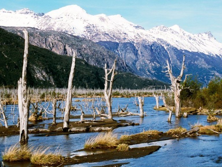
© John Warburton-Lee/Getty ImagesDead trees in the River Ibanez valley killed by ash from the Cerro Hudson eruption in 2011.
Last night, the ONEMI (Oficina Nacional de Emergencias) and SERNGEOMIN (Chilean Geological Survey) in Chile raised the alert status for the area around Cerro Hudson in the southern Andes.

Normally, raising the alert status like this is due to an acute change, when the behavior of the volcano shifts suddenly. However, this time, the elevation to Yellow alert status at Cerro Hudson is due to accumulated events over the past month.

Dozens of small earthquakes have occurred since the start of November, none stronger than M3.2. But their location (in geographic space and depth) are similar to those before the last eruption of Hudson in 2011. The number of earthquakes hasn't increased much above the baseline activity at an active volcano like Hudson, but energy released by the largest earthquakes has been increasing over the past few months.

Combine that with the fact that the earthquakes have the character of those associated with magma movement, and the SERNAGEOMIN and ONEMI decided to treat Hudson with an abundance of caution, setting up a 3.5 kilometer exclusion zone around the volcano.
Seismograph

Magnitude 6.2 earthquake rocks Trinidad and Tobago

6.2 magnitude earthquake rocks Trinidad and Tobago.
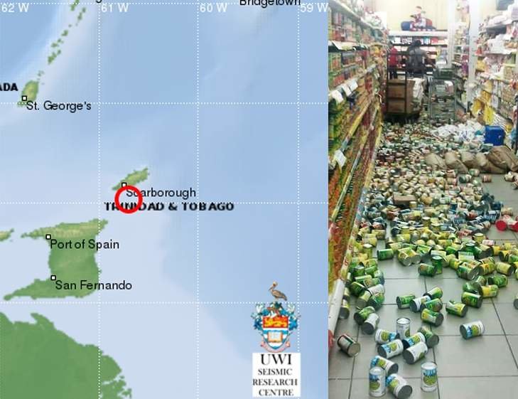
© UWI Seismic/ Image from social media6.2 magnitude earthquake rocks Trinidad and Tobago.
An earthquake with a magnitude of 6.2 rocked Trinidad and Tobago on Tuesday evening sending people into the streets and throwing items of the shelves of some stores and supermarkets.

The Seismic Research Centre (SRC) at the St Augustine campus of the University of the West Indies (UWI) said that the quake, which occurred at 5:42 pm (local time), was located at a depth of 29 kilometres.

It said the 6.2 magnitude quake was felt in many parts of the country including Scarborough in Tobago.

The location was Latitude: 11.04N, Longitude: 60.70W.

Many people in the west of the capital scampered out into the streets as the buildings shook, throwing many items to the ground.

There were no immediate reports of injuries or damages.


Seismograph

Magnitude 6.0 undersea earthquake strikes eastern Indonesia, no tsunami alert

Underwater quake off Indonesia
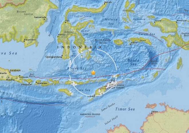
© USGS Indonesia’s disaster agency said officials were checking to see if the quake had any impact.
A strong earthquake of 6.0 magnitude has hit the coast of eastern Indonesia on Monday morning, according to the United States Geological Survey (USGS) seismologists.

USGS experts said the undersea quake struck at about 190 km north-east of Maumere, a holiday destination in Flores, at a depth of 522 km. The quake occurred at 9.13 am local time (9.1 3am Singapore time).

Indonesia's disaster agency said the officials were checking to see if the quake had any impact as there were no immediate reports of any casualties or damage. The authorities also said the quake did not trigger any tsunami alert.

Indonesia is positioned on the highly seismically active zone "Pacific Ring of Fire", which is known for collisions of tectonic plates, and hence it experiences frequent earthquakes.

Seismograph

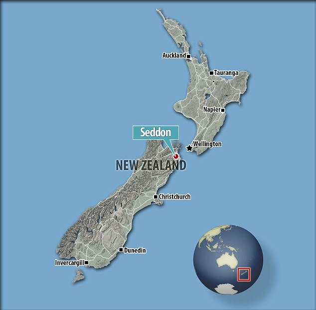
New Zealand rocked by 'severe' shallow earthquake of magnitude 5.5

The earthquake was at a depth of 12km and was centred 10km east of Seddon
New Zealand has been struck with another large magnitude 5.5 earthquake.

Just three weeks after the mammoth earthquake that shook central New Zealand, an earthquake has rocked South Island and lower North Island of New Zealand but fortunately hasn't done any damage.

It was at a depth of 12km and was centred 10km east of Seddon.

Marlborough District Council mayor John Leggett told AAP he was at a Christmas parade when the quake occurred.

'We were down on the foreshore and we definitely felt it. It was pretty significant,' he said.

Wellington City Council spokesman Richard McLean said, 'emergency controllers have been talking to each other' but there are no reports of damage in the capital.

Seismograph

1 dead, 17 hurt due to 5.5 magnitude earthquake in Peru

graph
A 5.5-magnitude earthquake that struck southeastern Peru killed one person, injured 17 others and damaged dozens of homes, officials said Friday.

"Authorities in the district of Ocuviri have confirmed the death of a minor and 17 injured who are now being assisted by medics," the National Civil Defense Institute (INDECI) said on Twitter after Thursday's quake.

The quake in the Puno region hit at 5:40 pm (2240 GMT) on Thursday, its epicenter 58 kilometers (36 miles) from the town of Lampa and at a depth of 30 kilometers, according to the Geophysical Institute of Peru (IGP).

"Eight collapsed homes are reported in Lampa and 40 affected in the Paratia district. People are located in safe areas," INDECI had earlier reported, adding that communication with the area had been disrupted.

IGP head Hernando Tavera reported that "the population was scared and took to the streets" in Lampa, which has 15,000 residents.

Blue Planet

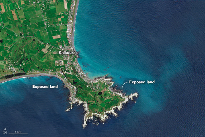
Powerful New Zealand earthquake exposes new land near Kaikoura

New land in New Zealand
© Sentinel data from the European Space AgencyPhoto acquired November 25, 2016

On November 13, 2016, a powerful earthquake jolted the northeastern coast of New Zealand's South Island. The 7.8 magnitude quake lifted the seabed by 0.5 to 2 meters (2 to 7 feet) along a 20-kilometer stretch of the Kaikoura coast. In one area, the uplift was a remarkable 5.5 meters (18 feet).

The sudden shifting of such a huge quantity of rock produced some unusual sights. From above, satellites captured an image of a thin swath of newly exposed land ringing the Kaikoura Peninsula and other parts of South Island.

On November 25, 2016, a multispectral imager on the European Space Agency's Sentinel 2 satellite captured an image (second) of the newly exposed land near Kaikoura. For comparison, the first image—acquired by the Operational Land Imager (OLI) on Landsat 8—shows the same area on October 12, 2016. The tidal water level was approximately the same in both cases.

Seismograph

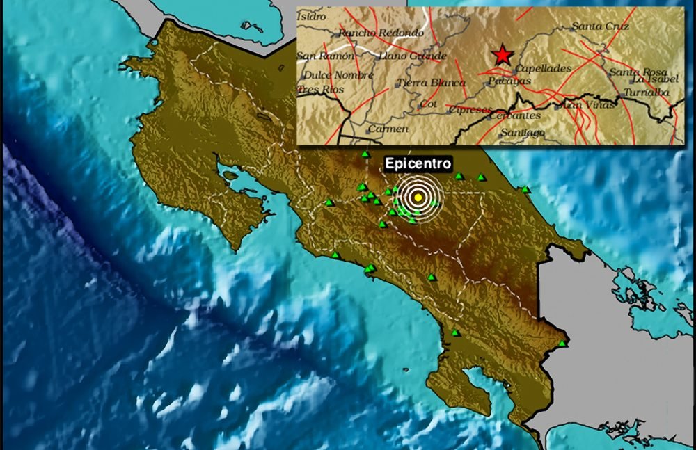
Magnitude 5.3 tremor hits Costa Rica, followed by 400 aftershocks

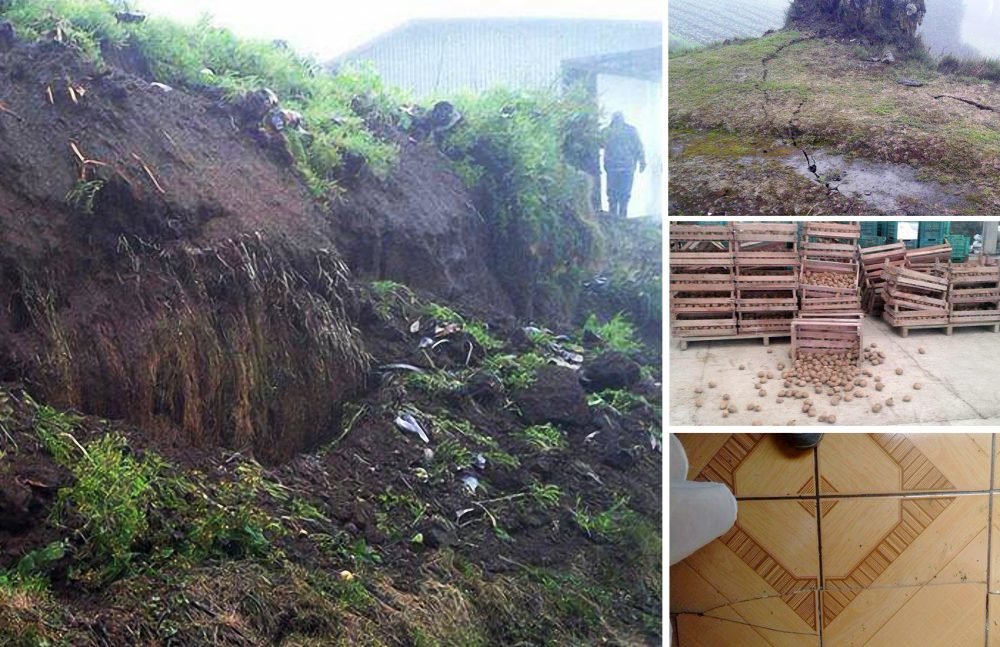
Gabriela Gómez posted images on OVSICORI’s Facebook page of landslides, fissures and other damage at her farm located in Capellades in northwestern Cartago province.
© Gabriela GómezGabriela Gómez posted images on OVSICORI’s Facebook page of landslides, fissures and other damage at her farm located in Capellades in northwestern Cartago province.
The National Emergency Commission (CNE) reported that at least one house collapsed and dozens are damaged in cantons east of Cartago due to the strong earthquake that shook the province at 6:25 p.m. Wednesday.

Red Cross spokesman Gerald Jiménez confirmed to The Tico Times on Thursday that the organization had not received any reports of injured people.

Fifteen people in the canton of Alvarado were evacuated to a shelter, following recommendations from the CNE and the Firefighters' Corps. Experts from both agencies are evaluating homes in the area to assess whether their occupants can safely return, the CNE reported.

In addition to some 40 damaged houses there are also reports of landslides and cracked roads in the Cartago cantons of Jiménez and Alvarado. People in Turrialba, Alvarado, Jiménez and Oreamuno suffered power and water cuts.

On Thursday evening there were still some 4,000 people without water in various communities in Jiménez.
The University of Costa Rica’s National Seismological Network reported the epicenter in Capellades, in northern Cartago province.
© UCRThe University of Costa Rica’s National Seismological Network reported the epicenter in Capellades, in northern Cartago province.

Seismograph

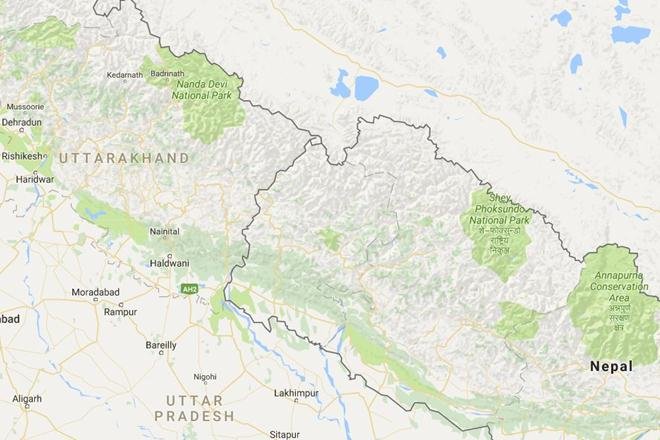
Shallow 5.2 magnitude temblor hits India-Nepal border

The tremors were felt in various parts of Uttrakhand including Champawat, Srinagar, Garhwal and Almora. No casualties have been reported so far.
An earthquake measuring 5.2 intensity on Richter Scale has recently hit India-Nepal border. The tremors were felt in various parts of Uttrakhand including Champawat, Srinagar, Garhwal and Almora. No casualties have been reported so far.

This is the second time in a week that Nepal has witnessed the tremors. A couple of days back, same intensity earthquake, measuring 5.5 on the Richter Scale, hit the coastal area of Nepal with its epicentre being located at Solukhumbu district near the Everest region, which is around 150 km east of the capital Kathmandu. As per the country's National Centre for Seismology, a unit of Ministry of Earth Sciences, the quake occurred at a depth of 10 km.

Seismograph

6.3 magnitude earthquake hits Peru, damaging houses

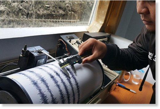
A man mapping the intensity of earthquake
An earthquake of 6.3 magnitude has hit southern Peru, the US Geological Survey reports. Several seismological reports have put the depth of the earthquake in the shallow range of 3-10 kilometers below the surface.

Germany's GEOFON program reported the depth of the quake to be 10 kilometers, while USGS has revised its initial data to 3.6 kilometers.


The earthquake was centered 79 kilometers west-northwest of the city of Juliaca (population 245,675) and 106 kilometers northwest of Puno (population 116,552).

Attention

'Unusual' seismic activity reported in New Zealand's North Island

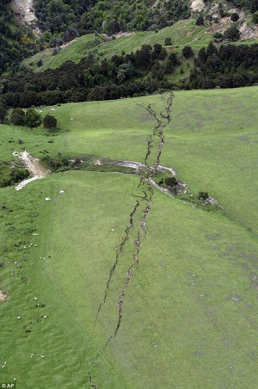
giant crack in New Zealand hill
© APThis photograph of a giant crack in the side of a hill in New Zealand shows where the earth split in two following the recent 7.8 magnitude earthquake
Civil Defence Minister Gerry Brownlee says a public statement about unusual seismic activity in the lower North Island is not a cause for alarm.

In a statement released this afternoon, Mr Brownlee said GNS Science had observed "unusual activity involving patches of slow-slip activity'' between tectonic plates under the region.

"The heightened activity increases the uncertainty about the likelihood and size of future earthquakes,'' he said.

Mr Brownlee said the observations by GNS were a timely reminder for New Zealanders to be prepared for earthquakes.

Speaking to reporters at Parliament later, the minister clarified that his statement did not amount to a warning about future quakes.

"I just want to make sure that what we are doing is putting that information out there that it is advisable to be prepared.

"We're not creating alarm, we're just creating awareness.''

Since the November 14 earthquake near Kaikoura, a series of simultaneous "slow-slip'' quakes have been observed in Gisborne, the Hawkes Bay, and Kapiti.

Slow-slip quakes move just millimetres at a time and are detected by GPS because they cannot be picked up by seismographs.

Comment: See also: