Earthquakes
S

Seismograph

Trinidad rattled by shallow earthquake of 4.2 magnitude

Earthquake
An earthquake with a magnitude of 4.2 rattled Trinidad on Tuesday, but there were no immediate reports of injuries or damages.

The Seismic Research Centre (SRC) of the University of the West Indies (UWI), said that the quake, which occurred 3.43 pm (local time) had a depth of 10 kilometers.

It said it was felt west of San Fernando, south of here and south-west of the capital, Port of Spain and south west of Arima, east of here.

The quake was located Latitude 10.24 degrees north and Longitude 62.17 degrees west.

On November 20, an earthquake with a magnitude of 4.8 hit Trinidad and Tobago. But in recent days, the SRC has recorded tremors in Dominica, grenada and Barbados.

Seismograph

Series of earthquakes recorded in northern and central Italy

Graph 2
Some residents of the northern Italian region of Emilia Romagna were woken up by a 3.7 magnitude earthquake on Wednesday morning, after a 4.4 magnitude quake was felt near L'Aquila on Tuesday evening.

A quake measuring 4.4 magnitude, at 17.14pm on Tuesday, was recorded by Italy's National Institute for Geophysics and Vulcanology. The epicentre was 22km away from L'Aquila, which was hit by a deadly earthquake in 2008, and the affected towns were Capitignano, Montereale, Campotosto, Barete and Cagnano Amiterno.

The tremblor was also felt in Amatrice, the town recovering from August's deadly quake, but no new building collapses have been reported.

In Emilia Romagna, an earthquake was felt at 6:52am on Wednesday morning, with its epicentre in Bagnolo in Piano, Reggio Emiliia. It followed a series of smaller tremors which took place throughout Tuesday night.

Fire fighters carried out checks on buildings and schools in the morning, however the local schools all remained open on Wednesday.

Seismograph

Shallow 5.7 magnitude earthquake strikes off Indonesia

A man mapping the intensity of earthquake.
A shallow undersea quake of magnitude of 5.7 struck eastern parts of Indonesia on Wednesday, the meteorology and geophysics agency said. No tsunami warning was issued.

The quake struck at 9.42 a.m. (local time) with epicentre at 86 km northeast Maluku Tenggara Barat and at depth of 10 km under the sea bed, Xinhua news quoted an official.

Indonesia is prone to quake as it lies on a vulnerable quake-hit zone called "the Pacific Ring of Fire". No casualties were reported.

Source: IANS

Seismograph

Shallow magnitude 4.4 earthquake leaves at least two miners dead in Poland

Miners arriving at the Rudna copper mine in south Poland
© Peter Andrews/Reuters file Miners arriving at the Rudna copper mine in south Poland.

Sixteen people were in the area of Rudna mine hit by magnitude 4.4 quake that struck at shallow depth in Polkowice district, says state media


An underground earthquake left at least two miners dead and six missing at the Rudna mine in Polkowice, south-western Poland, according to state media.

The earthquake of magnitude 4.4 struck just after 9pm Tuesday local time, according to the US Geological Survey.

The quake was centred a shallow 10km (6.2 miles) underground, the USGS said, which would have magnified its effect at the mine belonging to state-run copper producer KGHM.

"There were 16 people in the danger zone. Some of them were walked out," a spokeswoman for the company was quoted as saying by private radio RMF FM.

Attention

Geyser eruptions rattle residents in Rotorua, New Zealand

The geyser was seen from Ohinemutu Village, pictured.
© FAIRFAX NZThe geyser was seen from Ohinemutu Village, pictured.
A Rotorua resident woke to loud thuds on Monday morning and evacuated her home after realising it was water squirting from nearby geysers.

Lani Kereopa lives in Ohinemutu Village, on the edge of Lake Rotorua.

At 4.30am, she heard "six or seven loud thuds with what I now know was spray, water spray that woke me up".

"And I thought, was that fireworks? But it was at 4.30 this morning so I thought, it can't be roadworks or fireworks.

"So I laid in bed, just trying to figure out what that could have been. Then another one happened so I stood up, looked out the window.


Seismograph

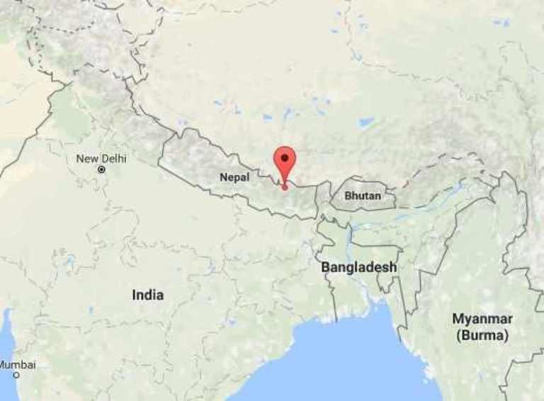
Shallow 5.4 magnitude earthquake hits Nepal, tremors felt in India and China

Nepal earthquake map Nov 2016
© Google
A strongly-felt earthquake with a preliminary magnitude of 5.4. has struck northeast Nepal, with shaking felt in Kathmandu and parts of China, India, Bhutan and Bangladesh, seismologists and residents are reporting.

The earthquake, which happened at 5:20 a.m. local time in Nepal on Monday, was centered about 18 kilometers (11 miles) northwest of Namche Bazaar in Nepal's Sagarmatha Zone. It struck at a depth of 10 kilometers (6.2 miles), making it a shallow earthquake.

Both the U.S. Geological Survey (USGS) and the European-Mediterranean Seismological Centre have put the preliminary magnitude of Monday's earthquake at 5.4.

Residents across the region reported feeling the early-morning tremor, but there was no immediate word about possible damage or casualties, though many residents reported that the tremors were strong enough to wake them up.

A resident in Banepa, about 110 kilometers west of the epicenter, described it as a "long shake". There were also many reports from Kathmandu. "Long mild shake felt and scary noise too at Lazimpat, Kathmandu. I was ready to jump off my bed and run," one resident told EMSC.

We're working to gather additional information.

Arrow Up

Outgassing of hydrogen sulfide and other gases off Kaikoura Peninsula, New Zealand

Kaikoura outgassing
© facebook/kaikoura kayaksBubbles have begun pluming out of the sea floor near where the epicenter of the earthquake that hit New Zealand earlier this month.
A Canterbury University lecturer has shed some light on the bubbles found off the Kaikoura Peninsula.

The phenomena was found in Whalers Bay by Matt Foy and Connor Stapley and it is believed they have been caused by the magnitude 7.8 quake.

Dr Matthew Hughes says the bubbles are likely dissolved gases in the sea floor which have become exposed by new cracks in the rock, and are now venting to the surface.

He says its very much like any other geologically active part of New Zealand.

The bubbles are a combination of several different gases, but the strong smell likely comes from hydrogen sulfide.


Comment: Here's a small sample we've collected of other recent natural outgassing related events: It is likely that outgassing of methane, hydrogen sulfide (and other natural gases) is coming up from deep below the earth's surface. See also:

SOTT Exclusive: The growing threat of underground fires and explosions


Seismograph

Shallow 5.1 earthquake hits Hawke's Bay, New Zealand

Graph 2
A "severe" magnitude 5.1 earthquake hit near Wairoa in the Hawke's Bay tonight.

Almost 1000 people reported on GeoNet having felt the earthquake, which followed a magnitude 4.6 jolt that shook Wellington about 3.20am.

GeoNet said the Wairoa earthquake struck at 13km deep at 8.21pm. It was centred 35km north of Wairoa.

Wellington's early-morning aftershock registered at a depth of 17 kilometres and its epicentre was 30 kilometres southwest of the capital, about halfway across Cook Strait.

More than 1500 people on either side of the strait reported feeling the shake on the government's seismic monitoring website, GeoNet.

Seismograph

Second earthquake strikes northwestern China near the border with Tajikistan and Kyrgyzstan.

Graph 2
A new earthquake has hit northwestern China near the border with Tajikistan and Kyrgyzstan.

A 5.0 magnitude earthquake has occurred in northwestern China, near the border with Tajikistan and Kyrgyzstan, where the day before a 6.7 magnitude earthquake was registered, the China Earthquake Networks Center (CENC) said on Saturday.

According to Chinese seismologists, the earthquake center was at a depth of 6 kilometers and was located in Akto county of the Kizilsu Kyrgyz Autonomous Prefecture in Xinjiang. Tremors were recorded at 17:23 (09:23 GMT).

There are currently no reported casualties.

On Friday night, the area was hit by a 6.7 magnitude earthquake. According to reports, the earthquake killed an Akto County resident. A total of six homes were affected by the earthquake.

Seismograph

Magnitude 6.5 earthquake hits northeast Tajikistan

Graph
Earthquake hits northeastern Tajikistan.

An earthquake with a magnitude of 6.5 struck northeastern Tajikistan, close to the borders with China and Kyrgyzstan, at 1424 GMT on Friday, the US Geological Survey said.

The quake, initially reported as a magnitude 6.8, struck at a depth of 75 kilometres.

Source: Reuters