Earthquakes
S


Bizarro Earth

USGS reports 6.6-magnitude quake hits off southern Pacific coast of Mexico

Map Tres Picos, Mexico
An earthquake with magnitude 6.6 occurred near Pijijiapan, Chiapas, Mexico at 19:49:54.80 UTC on Dec 17, 2015.

The quake location 15.892°N 93.429°W depth=96.9 km (60.2 mi) ENE of Tres Picos, Mexico.

Attention

5.2 magnitude earthquake strikes Ilocos Sur, Philippines

map Phillipines
A 5.2-magnitude earthquake struck near the town of San Juan in Ilocos Sur on Thursday evening (December 17), according to the Philippine Institute of Volcanology and Seismology (Phivolcs).

Aftershocks are expected, it added.

The United States Geological Survey (USGS), however, said the quake that struck at 8:44 p.m. had a magnitude of 5.4.

Strong quake felt in one town

Based on Phivolcs' earthquake intensity scale, an Intensity 5 or a strong quake was reported in the town of Sinait, more than 30 minutes drive from the town of San Juan.

Many sleeping people are awakened, while stationary vehicles rock noticeably at this intensity, the agency said.

Better Earth

Oklahoma reports surge in earthquakes during 2015

As 2015 nears its end, 850 earthquakes of magnitude three or greater have stirred the state of Oklahoma. Compared to 584 of the same magnitude in 2014 and 109 in 2013, the trend is clear: earthquakes are on the rise.

While Oklahoma's spike in earthquakes has been heavily publicized, Jeremy Boak, director of the Oklahoma Geological Survey, said it's less widely known that the state has been taking steps toward combating the pattern of induced seismicity.

Oklahoma earthquakes: 2013 through 2015
© CartoDB / Oklahoma Geological SurveyOklahoma earthquakes: 2013 through 2015

Comment: Putting "some" restriction? Again this Boak person sounds like he's doing damage control on behalf of unspecified interests in the oil and gas industry.


Attention

Over 100 earthquakes at Copahue volcano in one day, Chile

Copahue volcano
© AFP PHOTO / Antonio HuglichCopahue volcano
Is the Copahue volcano entering a new eruptive phase?

The volcano was hit by 103 earthquakes between December 12 at 10:17 local time (13.17 GMT) and December 13 at 1:09 local time (4.09 GMT), so less than 1 day. Insane.

103 seismic events rattled the Copahue volcano during last week-end as reported by the Service National of Geology and Mining of Chile (Sernageomin).

The earthquakes occurred 12 kilometers from the main crater at depths close to six kilometers underground.

The most powerful tremor was a M3.1 and happened at 12:57 local time (15.00 GMT) on Saturday.

Bizarro Earth

Earth's day is getting longer - Rotation is slowing down

Scientists reveal that the rotation of Earth's core holds a clue to understanding global sea-level rise.

Mathieu Dumberry
© University of Alberta
Scientists are studying past changes in sea level to make accurate future predictions of this consequence of climate change, and they're looking down to Earth's core to do so.

"In order to fully understand the sea-level change that has occurred in the past century, we need to understand the dynamics of the flow in Earth's core," says Mathieu Dumberry, a professor in the Department of Physics at the University of Alberta.

The connection is through the change in the speed of Earth's rotation. Meltwater from glaciers not only causes sea levels to rise, but also shifts mass from the pole to the equator, which slows down the rotation. (Picture the Earth as a spinning figure skater. The skater moves his or her arms in to spin more quickly or out to slow down.) The gravity pull from the Moon also contributes to the slowdown, acting a little like a lever brake. However, says Dumberry, the combination of these effects is not enough to explain the observations of the slowing down of Earth's rotation: a contribution from Earth's core must be added.

Attention

Seismic activity increases in Azerbaijan: 7,000 earthquakes in 2015

earthquake needle
Seismic activity intensified in Azerbaijan as the country faced about 7,000 earthquakes in 2015.

Magnitude of more than 80 earthquakes ranged from 3.1 to 5.9, and tremors of 17 were felt
, the Republican Seismological Service Center reported.

Azerbaijan locates in seismically active zone. Scientists believe that seismic zones with the potential to produce dangerous force cover the entire country, while the Alpine-Himalayan seismic belt passes directly through Azerbaijan.

An increase in seismic activity is observed since the beginning of the year in the northern part of Azerbaijan - in Oghuz, Shamakhi-Ismayilli, Shabran seismic zones, as well as in the southern part - the Talysh seismic zone, according to the center.

Fire

'This Gulf of Fire': The cataclysmic earthquake that leveled Lisbon

Fire
Mark Molesky’s richly readable new book “This Gulf of Fire” chronicles the catastrophic earthquake of 1755 that left Lisbon in ruins, killed almost 40,000 people in the city alone, and irrevocably altered the history of Portugal.
First came the earthquake. Then came the tsunami. Then came the all-consuming fire.

Economic chaos and a political power vacuum followed — from which a dictatorship arose.

Mark Molesky's richly readable This Gulf of Fire: The Destruction of Lisbon, or Apocalypse in the Age of Science and Reason paints an astonishing picture of the natural cataclysm that struck Lisbon on Nov. 1, 1755. But it goes well beyond that, too.

Molesky examines the historical consequences the earthquake had for Portugal. He weighs its effect on European thought (his title is borrowed from Voltaire). He traces how it spread as a news event across Europe and the Atlantic. He also argues that European aid to Portugal constituted "the first international relief effort in world history."

Alarm Clock

Another earthquake swarm shakes Idaho, US

earthquake swarm
© WFAA
More than 40 small earthquakes have been recorded in east-central Idaho this week in what experts say is another earthquake swarm in the region.

Officials in the Challis area on Friday reported no damage from the micro-quakes that started Tuesday and have mostly gone unnoticed or unreported in an area experienced with more vigorous shaking.

But the temblors ranging up to 2.9 magnitude have perked up scientists trying to understand the fault system in the area where a 5.0 magnitude quake struck in January.

Idaho's largest recorded earthquake rocked the same area in 1983 when a 6.9-magnitude quake occurred near 12,667-foot Borah Peak, Idaho's tallest peak.

University of Idaho research geologist William Phillips says scientists aren't sure if the current earthquake swarm could lead to something bigger.

Source: Associated Press

Comment: Elsewhere in the US recently, more than 50 small earthquakes shook the Pacific northwest within a week, whilst over 600 earthquakes rattled San Ramon, California in the space of a month - setting a new record.


Attention

Series of earthquakes hit in some parts of Mindanao, Philippines

Earthquake map
© PhivolcsEpicenter map of 4.6 earthquake courtesy of Phivolcs
A series of earthquakes struck in some parts of Mindanao yesterday, December 10, 2015.

However, the various provincial disaster risk reduction and management councils in said areas reported no damage or casualty in yesterday's tremor.

The Philippine Institute of Volcanology and Seismology (Phivolcs) said that the initial earthquake with 3.2 magnitude was registered at 11:45 a.m. on December 10. Its epicenter was plotted at 147 kilometers (km) northeast of Lingig town, Surigao del Sur, with a depth of 29 km.

A magnitude 3.5 tremor followed at 3:36 p.m. of the same day, with epicenter traced at 12 km southwest of Governor Generoso town, Davao Oriental, with a depth of 28 km.

Attention

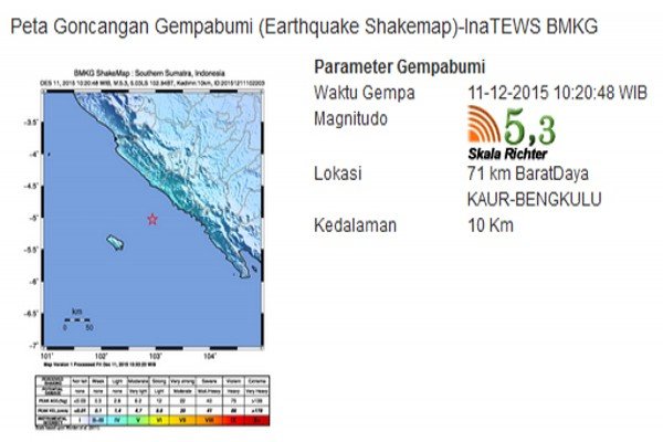
5.3 magnitude earthquake jolts Bengkulu, Indonesia

Earthquake Indonesia
An earthquake measuring 5.32 on the Richter scale jolted Kaur District, Bengkulu Province, on Friday at 10:20 a.m. local time.

"The earthquake occurred due to a collision between the Indo-Australian and Eurasian plates," Litman, the head of the Kepahiang meteorology, climatology and geophysics office, stated here on Friday.

The quakes epicenter was located at 5.03 degrees southern latitude and 102.94 degrees eastern longitude, some 71 kilometers (km) southwest of Kaur District at a depth of around 10 km, he revealed.

The tremors of the earthquake could be felt in six districts and cities in Bengkulu, or up to hundreds of kilometers away from the epicenter.

The earthquake did not have the potential to trigger a tsunami.