Earthquakes
S


Attention

2.7 earthquake hits Bergheim, Germany

earthquake needle
Residents of a suburb of Cologne were jolted from their sleep on Tuesday morning when an earthquake hit western Germany.

Phones at the local police station were ringing off the hook as shaken locals called in to report the incident, Focus magazine reports.

"We can confirm that the earthquake took place. So far twelve people have called in to tell us about it," a spokesperson for the police in Bergheim said.

"Concerned residents mentioned shaking wardrobes," the spokesperson continued, adding that "we're in contact with the fire services."

Witnesses reported that the tremors lasted around five seconds and were "surprising, sharp and short."

Authorities are now checking houses for possible damage.

Bizarro Earth

New theory to explain the San Adreas fault - zipper fault

San Andreas Fault
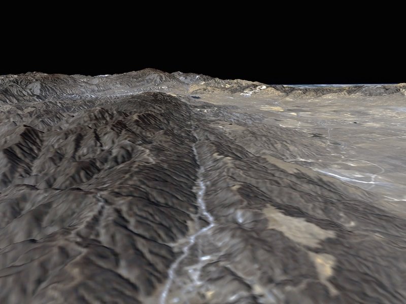
© NASA/JPL/NIMAThis segment of the San Andreas Fault, in Palmdale, California, lies about 60 miles (100 km) northwest of Los Angeles. The image was captured from the Space Shuttle Endeavor on Feb. 11, 2000.
San Francisco — A new explanation for colliding faults could help explain mysterious fault lines that have mystified geologists for decades. The new explanation could explain everything from the quake-prone faults of Southern California to dynamic crust beneath the snow-capped peak of K2 in the Himalayas.

The theory is deceptively simple: When two faults collide, instead of one breaking past another, they may just merge, like a zipper zipping up, said John Platt, a geologist at the University of Southern California in Los Angeles, here at the annual meeting of the American Geophysical Union. [Photo Journal: The Gorgeous San Andreas Fault]

"It may solve some long-standing and intractable problems concerning the timing and displacement on faults," Platt said in the presentation.

Attention

4.0 magnitude earthquake felt in Batangas, Philippines

Epicenter map
© PhivolcsEpicenter map
A moderately strong earthquake measuring 4.0-magnitude on the Richter scale has jolted parts of Batangas and Laguna afternoon of December 21, 2015, the Philippine Institute of Volcanology and Seismology (Phivolcs) reported.

The 4.0-magnitude earthquake was recorded at 12:42 p.m. and originated at 10 kilometers northeast of Tanauan City, Batangas.

It was felt at Intensity 4 or moderately strong in Tanauan City and Sto. Tomas in Batangas, and Los Baños in Laguna.

Phivolcs said an earthquake with this intensity is comparable to the "vibration of a passing heavy truck that is felt by people indoors and some people outdoors and may awaken light sleepers."

Intensity 3 was felt in Malvar, Batangas and San Pablo City in Laguna, which is relatively weak, "but some people may experience dizziness and nausea."

Attention

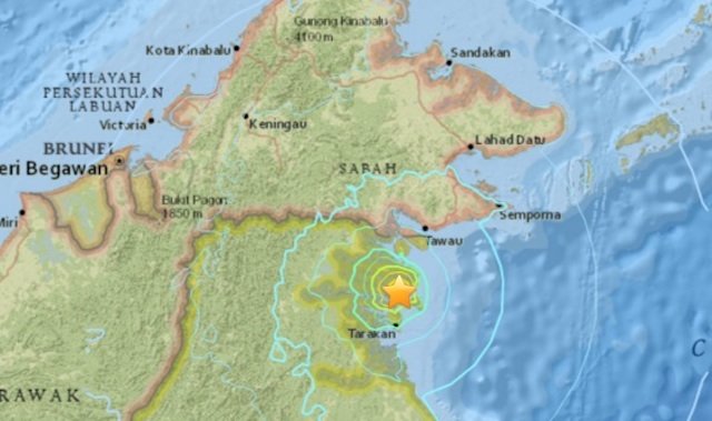
6.0-magnitude earthquake rattles Indonesia's Borneo

Indonesia earthquake
© USGS
A strong 6.0-magnitude earthquake struck Indonesia early on Monday (Dec 21), the US Geological Survey (USGS) said, but no immediate damage or casualties were reported.

The quake, which was relatively shallow, struck the northeastern corner of Kalimantan on the Indonesian part of Borneo island, 34 kilometres north of the coastal city of Tarakan, according to the USGS. The agency reported the quake hitting at a depth of 22 kilometres.

Indonesia's tsunami warning centre said there was no potential for the quake to trigger a tsunami. There were also no immediate reports of damage.

The archipelago nation sits on the Pacific "Ring of Fire" where tectonic plates collide, causing frequent seismic and volcanic activity in the region.

Last month, a 6.1-magnitude undersea earthquake struck eastern Indonesia that was felt in Saumlaki and prompted some residents to run outside, though the tremor had no tsunami potential, disaster officials said.

Earlier in November, two powerful quakes struck Sumatra - an initial 6.1-magnitude undersea tremor followed hours later by a strong 6.4-magnitude quake.
Attention

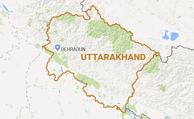
5.4 earthquake hits parts of Uttarakhand, India

Uttarakhand map
A moderate earthquake measuring 5.4 on the Richter scale rocked parts of Uttarakhand in the wee hours.
A moderate earthquake measuring 5.4 on the Richter scale rocked parts of Uttarakhand in the wee hours today.

Epicentred in the India-Nepal border region, the earthquake occurred at 3.47 am, the MeT department in Dehradun said.

As the tremors were moderate and occurred in the wee hours when people are usually asleep they were not felt by many, it said.

However, a report from Chamoli said the quake shook people out of their sleep in the district.

The tremors were also felt in Pithoragarh district which borders Nepal.

Source: Press Trust of India

Alarm Clock

Chile struck by 6.0 magnitude earthquake

chile earthqauke map
© google
A strong earthquake with a preliminary magnitude of 6.0 has struck east of the city of Ovalle in Chile's Limarí province, seismologists say, with shaking felt over a large area.

The earthquake, which struck at 4:25 p.m. local time on Saturday, was centered about 13 kilometers (8 miles) east of Ovalle, or 82 kilometers (51 miles) southeast of La Serena. It struck about 49 kilometers (30 miles) deep, making it a relatively shallow earthquake, according to Chile's seismological center.

The earthquake could be felt over a large area, with medium intensity shaking reported in the regions of Atacama and O'Higgins. There was no immediate word about possible damage or casualties.

Chile's seismological center initially put the magnitude of the earthquake at 6.2, but later downgraded it to 6.0. Chile's Hydrographical and Oceanographical Service of the Navy said the earthquake did not meet the characteristics necessary to generate a tsunami off the coast.

Arrow Up

Magnitude 6.2 earthquake hits near Vanuatu islands, South Pacific Ocean

Vanuatu islands
© USGS
A magnitude-6.2 earthquake has struck north-east of the Vanuatu chain of islands, the US Geological Survey said.

The quake had a depth of 10 kilometres, it said.

Nearby cities to the impact zone include Isangel, Port-Vila, We, Luganville and Dumbea.

There were no immediate reports of damage or injuries.

ABC/wires

Bizarro Earth

USGS reports 6.6-magnitude quake hits off southern Pacific coast of Mexico

Map Tres Picos, Mexico
An earthquake with magnitude 6.6 occurred near Pijijiapan, Chiapas, Mexico at 19:49:54.80 UTC on Dec 17, 2015.

The quake location 15.892°N 93.429°W depth=96.9 km (60.2 mi) ENE of Tres Picos, Mexico.

Attention

5.2 magnitude earthquake strikes Ilocos Sur, Philippines

map Phillipines
A 5.2-magnitude earthquake struck near the town of San Juan in Ilocos Sur on Thursday evening (December 17), according to the Philippine Institute of Volcanology and Seismology (Phivolcs).

Aftershocks are expected, it added.

The United States Geological Survey (USGS), however, said the quake that struck at 8:44 p.m. had a magnitude of 5.4.

Strong quake felt in one town

Based on Phivolcs' earthquake intensity scale, an Intensity 5 or a strong quake was reported in the town of Sinait, more than 30 minutes drive from the town of San Juan.

Many sleeping people are awakened, while stationary vehicles rock noticeably at this intensity, the agency said.

Better Earth

Oklahoma reports surge in earthquakes during 2015

As 2015 nears its end, 850 earthquakes of magnitude three or greater have stirred the state of Oklahoma. Compared to 584 of the same magnitude in 2014 and 109 in 2013, the trend is clear: earthquakes are on the rise.

While Oklahoma's spike in earthquakes has been heavily publicized, Jeremy Boak, director of the Oklahoma Geological Survey, said it's less widely known that the state has been taking steps toward combating the pattern of induced seismicity.

Oklahoma earthquakes: 2013 through 2015
© CartoDB / Oklahoma Geological SurveyOklahoma earthquakes: 2013 through 2015

Comment: Putting "some" restriction? Again this Boak person sounds like he's doing damage control on behalf of unspecified interests in the oil and gas industry.