Earthquakes
S


Attention

5.0 Magnitude earthquake strikes Southern Molucca Sea

earthquake needle
On Dec. 3, 2015, at 10:27:36 a.m local time, a 5.0M earthquake struck just off the coast in Southern Molucca Sea. The depth of the quake was reported to be 69 km, and the alert for aftershocks has been released, along with warnings of a potential tsunami due to the epicenter of the earthquake. Local villagers, as of this report, have not given details of any damage or injuries. However, local officials warn that the damage could be extensive, and reach beyond the immediate area, expanding up to 13km away.

According to Geoscience Australia that commonly monitors the area for earthquakes and other natural disasters, it is estimated that people as far away as 169km could have felt the 5.0 quake that took place today. The local Department of Emergency Management is ready to respond should authorities determine a state of emergency is needed to deal with the impending fallout from the earthquake. The most recent quake is the second one for the region in just three days. Fortunately, there were no reported injuries as a result.

Source: Geoscience Australia Earthquakes: Earthquake Details

Attention

3.2 magnitude earthquake strikes near Julian, California

EARTHQUAKE REGISTER 2
A shallow magnitude 3.2 earthquake was reported Wednesday afternoon 9 miles from Julian, Calif., according to the U.S. Geological Survey. The temblor occurred at 3:27 p.m. at a depth of 3.7 miles.

According to the USGS, the epicenter was 19 miles from San Diego Country Estates, Calif.; 22 miles from Alpine, Calif.; and 24 miles from Ramona, Calif.

In the last 10 days, there has been one earthquake of magnitude 3.0 or greater centered nearby.

This information comes from the USGS Earthquake Notification Service and this post was created by an algorithm written by the author.

Info

Earthquakes in the Eastern Mediterranean? Much more frequent in past than thought

Crete
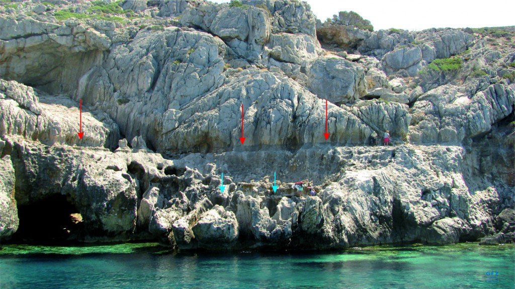
© Vasiliki Mouslopoulou, GFZScientists look for remnants of paleo shorelines on western Crete. Red and blue arrows indicate paleo shorelines formed during the last 2,000 years and are today elevated up to 8 meters (26 feet).
There is more seismic activity in the eastern Mediterranean than was previously thought, and a study about this was recently accepted for publication in the journal Geophysical Research Letters.

Historically in the long stretch of geological time, seismic activity near and around Crete has stirred up bursts of earthquakes, and this may increase the region's future risk of earthquakes and tsunamis, according to a release.

Several tectonic plates are in the Mediterranean basin, caused by the African and Eurasian Plates crashing together there. While scientists have been aware that the collision between the two plates can make the eastern part of that sea and land area susceptible to earthquakes, they've also been confused by the region having gone through only two (known) earthquakes larger than 8 on the Richter scale in 4,000 years.

The African Plate goes under the Aegean microplate just south of Crete. This occurs in an area shaped like an arc, which is called the Hellenic margin. The scientists in the study looked at the history of earthquakes in this subduction zone, to learn what could drive mega-earthquakes in the area.

Attention

Magnitude 4.6 earthquake strikes southern Alaska

map alaska
A magnitude 4.6 earthquake has struck in southern Alaska.

The U.S. Geological Survey says the earthquake hit just after 2 a.m. local time and was centered about 48 miles (79 kilometers) northwest of Valdez and 93 miles (150 kilometers) east-northeast of Anchorage.

The survey says the quake was about 21 miles (35 kilometers) deep.

The National Tsunami Warning Center says a tsunami is not expected.

Source: AP

Attention

Eastern Taiwan shaken by two moderate earthquakes

map taiwan earthquake
© Central Weather Bureau
Two earthquakes measuring 4.7 and 4.5 on the Richter scale, respectively, hit eastern Taiwan Wednesday afternoon, according to the Central Weather Bureau.

The magnitude 4.7 earthquake took place at 1:21 p.m., with the epicenter located at sea about 37.9 kilometers east of Hualien County Hall at a depth of 5 km.

The strongest tremor, which posted an intensity of 4 on Taiwan's 7-tiered intensity scale, was felt in Hualien County's Taroko scenic area, bureau data showed.

The temblor was followed by a smaller one at 1:53 p.m., also centered at sea about 34.5 km east of Hualien County Hall at a depth of 21.9 km.

It measured an intensity of 3 in Heping Township in Hualien.

Attention

Earthquake of 5.0 magnitude recorded in Arequipa, Peru

Earthquake register
An earthquake of magnitude 5.0 grades *on the Richter scale struck the region of *Arequipa this morning, according to a report by the Geophysical Institute of Peru (IGP).

The quake was recorded at 8:39 a.m. this morning and surprised locals with a regular intensity, reports El Comercio.

The epicenter was located 29 kilometers southeast of Arequipa, with a depth of 128 kilometers.

According to INDECI, no material damages or personal injury were caused by the earthquake.

Attention

Magnitude 5.2 earthquake rocks Kyrgyzstan

Image
A magnitude 5.2 earthquake rocked the region 40 km south of Uch-Terek in Kyrgyzstan at 6:13 UTC time Tuesday morning.

The remote region has some tourism. Arslanbob a small town close to the epicenter is known for its picturesque valley, mountain range, and a large wild walnut forest. It's the Jalal-Abad Province of Kyrgyzstan. Kyrgyzstans first known export to Europe was the Arslanbob walnut. Two waterfalls are located in the area which attract tourists, pilgrims and other visitors during the spring and summer months.

According to USGS the earthquake location was:

40km (25mi) S of Uch-Terek, Kyrgyzstan
53km (33mi) NNE of Jalal-Abad, Kyrgyzstan
54km (34mi) NE of Bazar-Korgon, Kyrgyzstan
56km (35mi) SSE of Toktogul, Kyrgyzstan
200km (124mi) SW of Bishkek, Kyrgyzstan

No reports of damages or injuries are yet known.
Attention

4.7 magnitude earthquake among 7 recorded in 1 day in Oklahoma, becoming one of the most earthquake-prone areas in the world

Oklahoma earthquake damage
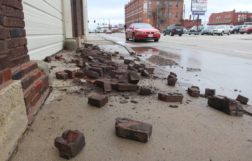
© Brian Corn The Wichita EagleFallen bricks were discovered Monday on a sidewalk in the 100 block of South Washington. The bricks fell from above a vehicle entrance to the building. Some are wondering whether the damage is the result of a magnitude-4.7 earthquake that happened early Monday. (Nov. 30, 2015)
At least seven earthquakes rattled north-central Oklahoma on Monday, including one felt as far away as Iowa, prompting concern from residents and policymakers that the state isn't doing enough to curb the quakes that scientists have linked to oil and gas activity.

Oklahoma has become one of the most earthquake-prone areas in the world, with the number of quakes of magnitude 3.0 or higher skyrocketing from a few dozen in 2012 to more than 720 so far this year. Many of the earthquakes occur in swarms in areas where injection wells pump salty wastewater - a byproduct of oil and gas production - deep into the Earth.

"It lasted for several seconds, but it's hard to tell when you just wake up," resident Frankie Robbins said of the 4.7 temblor that hit before 4 a.m. on Monday about 16 miles from his home in Medford, which is about 80 miles south-southwest of Wichita.

The shaking was felt in Wichita as well.

Dozens of bricks fell from above the doorway to a 75-year-old building on Washington just south of Douglas early Monday, and the owners of the building say the earthquake may have caused or contributed to the damage.

Comment: US Geological Survey statistics show that 40% of all major earthquakes located in the lower 48 states have occurred in Oklahoma this year. Cushing in Oklahoma is home to the largest commercial crude oil storage center in North America, and is dotted with hundreds of airplane hangar-sized tanks that hold an estimated 54 million barrels of oil. These tanks were built to national standards that account for some shaking, but they weren't constructed with serious earthquakes in mind, which is causing concern to Homeland Security according to Daniel McNamara, a USGS research geophysicist.

See also: A disaster waiting to happen in Oklahoma? The link between fracking and earthquakes is causing alarm in a town where oil storage is 'booming'

Seismic activity in the Oklahoma area over the past couple of months include: There is growing evidence that fracking and earthquakes are linked:


Bizarro Earth

Argentina 5.9 earthquake: Tremor hits Jujuy and Salta near San Salvador

Argentine Earthquake map
A strong earthquake with a preliminary magnitude of 5.9 has struck the provinces of Jujuy and Salta in northwest Argentina, near the city of San Salvador de Jujuy, seismologists say.

The earthquake struck at 3:52 p.m. local time and was centered about 9 kilometers west of Yuto, or 91 kilometers northeast of San Salvador de Jujuy. It struck about 10 kilometers deep, making it a shallow earthquake, according to seismologists.

Residents in the region reported feeling the earthquake, but there was no immediate word on damage or casualties.

Computer models from the U.S. Geological Survey (USGS) estimated that as many as 2.1 million people may have felt the earthquake, including some 29,000 people who may have perceived strong shaking. Those in Yuto and Caimancito are likely to have felt the worst shaking.

Other details about Sunday's earthquake were not immediately available.

Attention

Shaking all over: Two 5.0 magnitude earthquakes hit Turkey

Image
On Nov. 29, at 00:28 UTC, an unconfirmed magnitude (M) 5.0 earthquake erupted in Turkey. The epicenter was 10 km deep. According to GEOFON Program, the coordinates of the epicenter were 37.87ºE 38.90ºN.

At the same time, Central Turkey experienced a 5.0M quake that was 22 km deep and five minutes later, a 3.0M aftershock, five km deep continued to rock the cities nearby.

Nearby cities included:

Kulucak, Turkey - 7 km

Hekimhan, Turkey - 16 km

Darende, Turkey - 42 km

Gurun, Turkey - 45 km

Ankara, Turkey - 437 km