Earthquakes
S


Attention

5.6 magnitude earthquake shakes Greater Jakarta, Indonesia

Image
An earthquake measuring a magnitude of 5.6 on the Richter scale shook Jakarta and its surrounding cities at 9:47 p.m., on Saturday.

According to the Meteorology, Climatology and Geophysics Agency (BMKG), the quake was centered 77 kilometers from southeastern Pandeglang, Banten, at a depth of 75 kilometers.

Social media users from Bogor, Depok, Sukabumi and Bekasi in West Java and Tangerang in Banten said they felt the shake in their respective regions.

Meanwhile, people residing near the quake felt an even greater shake.

"Me and my whole family went outside in fear of falling walls," said Uni, a resident of Rangkas Bitung, Banten, as quoted by antara.com.

Two hours before the Banten quake, the agency recorded an earthquake 49 kilometers from southeastern Kepulauan Talaud in North Sulawesi.

Attention

Magnitude 6.2 earthquake strikes off Chile coast

Image
A magnitude 6.2 earthquake struck off the northern coast of Chile on Friday, the U.S. Geological Survey said, although there were no initial reports of damage.

The USGS said the quake's epicenter was located 18 miles (29 kilometers) below the seabed, 82 miles (132 km) southwest of Antofagasta.

The quake, initially reported as a magnitude 6.0, struck at 6 p.m. (2100 GMT).

Local emergency services said the tremor was felt strongly in the northern Atacama desert, and they were assessing whether it had caused any damage. The navy said it was not issuing a tsunami alert.

A spokesman for Chilean state copper producer Codelco [COBRE.UL] said there were no reports of any damage at its mines in the area.

Chile, located on the so-called Pacific ring of fire, is prone to earthquakes and has strict building codes that limit damage when they occur.

Attention

12 small earthquakes in 2 hours hit New Madrid fault near Marston and Lilbourn, Missouri

Image
© CERI at the University of Memphis
Residents in southeast Missouri might have felt the ground shake when 12 earthquakes rattled within hours of each other on Wednesday.

All the quakes were located just northeast of Marston and south of Lilbourn.
Image
© KFVS12
People in Risco, Dexter, Matthews, and New Madrid said they felt the quakes.

"[I] felt it in New Madrid sounded like a big clash of thunder & a little shake happened like a semi truck passing by," Mark Kientzy said in a comment on Facebook.

A man and his son were installing a water line at the New Madrid Airport on Wednesday, right in the center of the quakes. While William Kosky, Jr. said he didn't feel any while he was working, he said he felt several on Tuesday night at his home.

New Madrid County, Missouri has a shaky history, with the most violent series of earthquakes ever recorded in the United States hitting in New Madrid in about a seven week stretch between 1811 and 1812, according to the USGS.
Image

Binoculars

Seismologists watching Glacier Peak in Washington after 4 earthquakes in under 4 hours

Image
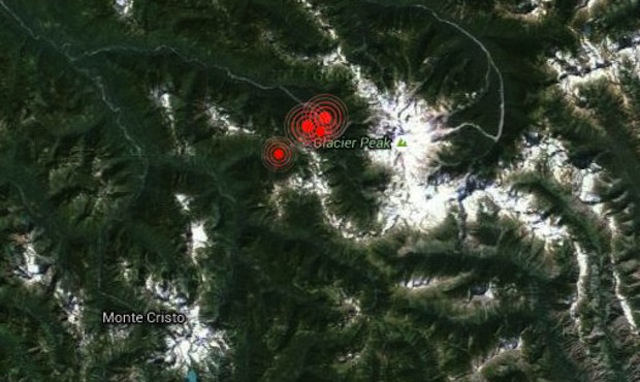
© Earthquake TrackerTwo earthquakes - magnitude 3.1 and 3.5 - struck Wednesday afternoon near Glacier Peak within an hour of each other. Two more smaller earthquakes struck just hours later.
Four earthquakes struck within hours of each other Wednesday afternoon near Glacier Peak in Washington.

The first two earthquakes registered at magnitudes 3.1 and 3.5. The first earthquake occurred at 12:11 p.m. The second registered roughly an hour later at 1:20 p.m. Then a third earthquake — a magnitude 1.6 — occurred at 2:33 p.m. And finally a fourth earthquake — a magnitude 1.4 — was registered at 3:44 p.m. All the quakes were recorded roughly 19-21 miles east-southeast of the town of Darrington.

Seth Moran, geophysicist at the University of Washington, tells KIRO Radio they're keeping a close eye on the area and continue to watch the seismic records. "Magnitude 3 earthquakes happen in Washington and Oregon a number of times per year," Moran said. "The one thing that makes these potentially interesting in a different way is they're somewhat close to Glacier Peak."

The quakes, about three miles from Glacier Peak, occurred where there haven't been a lot of magnitude 3 earthquakes in the past, according to Moran. "The last time there was a magnitude 3 in the vicinity was in 1991," Moran said. However, there isn't a great network of seismic instruments in the area. There have been no reports of damage or injuries.

According to the USGS, the last time Glacier Peak erupted was 1,100 years ago. Mount St. Helens and Glacier Peak are the only volcanoes in Washington state that have been explosive in the past 15,000 years.

Comment: U.S. Geological Survey decides to keep a closer eye on the slumbering giant Glacier Peak volcano


Attention

Four new earthquakes recorded at Peru-Brazil border

Image
© El Comercio/IGPThe border with Brazil has produced four new quakes today.
Two of the earthquakes were felt and two were not felt by the local communities.

Four new earthquakes registered today northwest of the district of Ucayali, at magnitudes of 6.5, 5.1, 4.6 and 5 on the Richter scale, reports the Geophysical Institute of Peru (IGP).

These quakes come days after the two 7.6 magnitude earthquakes that hit in the same zone of the Peruvian border with Brazil on Tuesday evening.

At the moment, no damages have been reported due to the earthquakes registered today.

The first quake hit at 12:45 a.m. and the epicenter was located north of Esperanza in Ucayali at a depth of 580 kilometers, with a magnitude of 6.5 grades.

The second was recorded at 12:57 a.m. with a magnitude of 5.1 grades. The third was recorded at 1:01 a.m. with a magnitude of 4.6 grades, while the fourth was recorded at 8:42 a.m. and had a magnitude of 5 grades.

Attention

Magnitude 6.4 earthquake strikes western Brazil

Image
A large but very deep 6.7 magnitude earthquake hit western Brazil today, the US Geological Survey said.

The earthquake struck at 12:45 am (5:45 GMT) at a depth of 375 miles (604 kilometers). It occurred some 81 miles southwest of the town of Tarauaca and 436 miles northeast of Lima, Peru.

The USGS had initially reported the earthquake's magnitude at 6.4.

No immediate reports of damage or casualties were reported after the temblor.

Deep South American earthquakes primarily occur in two zones: beneath the Peru-Brazil border, where today's earthquake hit, and also in an area running from central Bolivia to central Argentina, according to USGS.

Source: Agence France-Presse

Attention

Great magnitude 8.2 earthquake strikes Bolivia

Image
Date & time: Tue, 24 Nov 22:48:00 UTC

Local time at epicenter: 2015/11/24 17:48:00

Magnitude: 8.2

Depth: 0.0 km

Epicenter latitude / longitude: 21.65°S / 62.4°W

Nearest volcano: Nuevo Mundo (473 km)

Primary data source: IGEPN

Bizarro Earth

Magnitude 7.5 quake jolts Peru-Brazil border

Peru earthquake
© earthquake.usgs.gov
A powerful 7.5 magnitude earthquake, initially reported as 6.9, has struck eastern Peru, close to the border with Brazil, according to USGS.

The quake was extremely deep, some 600 kilometers below ground level. Besides Peru and Brazil, shaking has also been felt in neighboring Bolivia.

The epicenter of the quake was located in an unpopulated area of the Amazon Basin, 175 kilometers from the closest Peruvian town of Iberia, and some 250 km from the Brazil's Brasileia and Bolivia's Cobija.


Blue Planet

UN Report: Major rise in weather disasters over last 2 decades

Image
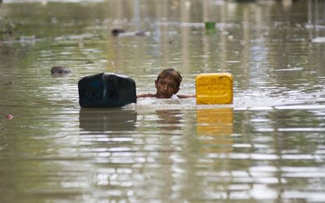
© AFPA flood-affected resident swims through floodwaters in Kalay, upper Myanmar’s Sagaing region on August 3, 2015. Relentless monsoon rains have triggered flash floods and landslides, destroying thousands of houses, farmland, bridges and roads with fast-flowing waters hampering relief efforts.
Since 1995, weather disasters have killed millions of people & left billions injured & homeless.

Weather-related disasters such as floods and heatwaves have occurred almost daily in the past decade, almost twice as often as two decades ago, with Asia being the hardest hit region, a UN report said on Monday.

While the report authors could not pin the increase wholly on climate change, they did say that the upward trend was likely to continue as extreme weather events increased.

Since 1995, weather disasters have killed millions of people, left billions injured, homeless or in need of aid, and accounted for 90 percent of all disasters, it said.

A recent peak year was 2002, when drought in India hit 200 million and a sandstorm in China affected 100 million.

But the standout mega-disaster was Cyclone Nargis, which killed 138,000 in Myanmar in 2008.

Attention

One killed in rockslide triggered by 5.1 magnitude earthquake in Venezuela

Image
One person was killed in Venezuela when a rockslide was triggered by a 5.1-magnitude earthquake in the state of Mérida, causing a traffic collision.

The Venezuelan Foundation of Seismological Research, or FUNVISIS, reported the epicenter of the earthquake was located about 18 miles southeast of the town of El Vigía at 4:08 p.m. at a depth of about 3 miles. Multiple aftershocks were recorded in the region.

Blas Federico Méndez, 41, died immediately and his son Emmanuel Méndez, 32, was injured after their vehicle made a frontal collision with an SUV. Both vehicles attempted to evade debris from a rockslide, but collided in the process. Two people inside the SUV were injured, El Universal reported.