Earthquakes
S


Arrow Down

Earthquake causes large sinkhole outside Ioannina, Greece

Sinkhole
An investigator from the fire department takes photographs of a large sinkhole that swallowed up part of a dirt track and an olive grove in Kalpaki, a rural area outside Ioannina in northwestern Greece, on Saturday.

The sinkhole is estimated to have a depth of 20-30 meters at least, and an overall surface area of around 200 square meters, and is believed to have been caused by a series of earthquakes that struck the region a week ago.

On October 14, Ioannina was hit by a strong tremor measuring 5.4 on the Richter scale and followed by hundreds of aftershocks, some of them quite powerful.

Bizarro Earth

Magnitude 6.6 earthquake hits western Japan's Tottori

Richter magnitude scale
© AFP 2016Richter magnitude scale
An earthquake with a preliminary magnitude of 6.6 shook western Japan on Thursday, the Japan Meteorological Agency said, adding that a tsunami warning was not issued.

Bizarro Earth

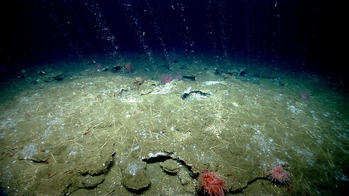
Methane gas seep discovered at the Cascadia Subduction Zone

Methane gas
© NOAA Okeanos ExplorerMethane gas bubbling up out of cold seeps on the Atlantic Ocean floor offshore Virginia.
From British Columbia to Northern California, planet Earth's got a case of the toots. A recent deep ocean mapping survey has learned that a geologically-active strip of seafloor called the Cascadia Subduction Zone is bubbling methane like mad. It could be one of the most active methane seeps on the planet.

"It's like bottles of champagne all along the seafloor," said Jesse Ausubel, an organiser for the 2016 National Ocean Exploration Forum, where the gaseous discovery, along with other intriguing finds from recent deep ocean surveys, is being presented this week.

For years, scientists have been aware that methane, an odourless, colourless gas produced naturally during microbial digestion (and more famously, by farting cows) bubbles up from the seafloor where the conditions are right. Recent scientific surveys have discovered hundreds of methane seeps along the Atlantic continental margin, and it's believed there could be thousands more across the world.

Understanding these seeps — where and when they occur, and what controls their activity — is a hot topic in Earth science research today, given that methane is a potent greenhouse gas. In fact, many scientists worry that by warming the oceans, climate change is speeding up the very processes that produce methane, in addition to melting icy methane hydrates that accumulate on the seafloor. In theory, this could lead to an enormous release of heat-trapping gases to the atmosphere.

Bizarro Earth

Study finds hidden connection between two dangerous fault zones in San Francisco

san francisco fault lines connected
The longer a fault stretches, the bigger the earthquake it can produce.
The most dangerous earthquake fault in the San Francisco Bay Area is connected to another, which means both could rupture simultaneously and unleash major devastation, a new study finds.

The Hayward Fault has long been considered a threat because it runs under densely populated neighborhoods east of San Francisco. The new work found that beneath San Pablo Bay, it joins with a second, less active underground fracture to the north.

Scientists had already considered the possibility of both faults rupturing at once, whether they are connected or not. So the discovery doesn't change the estimated earthquake hazard much, although it confirms suspicions that the stage is set for what could be a massive quake.

If the Hayward and Rodgers Creek faults broke simultaneously along their combined 118 miles, they could produce a magnitude 7.4 quake, said scientists from the U.S. Geological Survey.

Seismograph

6.5 magnitude earthquake rocks Subang, Java

Earthquake illustration
© TEMPO/Prima Mulia
A 6.5-magnitude quake rocked Subang District, West Java, this morning. The Meteorology, Climatology and Geophysics Agency (BMKG) website says that the earthquake occurred at 7:25 am.

The same source says that the epicenter of the quake was at a latitude of 5.29 degrees south and a longitude of 108 degrees east, 120 kilometers northeast of Subang, 654 kilometers below the sea.

According to the head of Data, Information and Public Relations, the National Disaster Mitigation Agency (BNPB), no injuries nor casualties reported after earthquake. "As of now, there are no victims," he told Tempo via text message.

According to the data from the BNPB, the quake has no potential to cause a tsunami. However, it was felt in several regions in West Java, such as Cikarang, Indramayu, Cirebon, Cianjur, etc.

Map earthquake
© Google Epicentre of earthquake

Seismograph

Shallow magnitude 3.8 earthquake strikes in central California

Ridgemark quake map
© USGS
An earthquake with a preliminary magnitude of 3.8 struck near Ridgemark Tuesday afternoon, according to the United States Geological Survey.

The earthquake struck at 2:09 p.m. The quake struck 6 miles south-southeast from Ridgemark and 10 miles outside of Hollister, and at a depth of 4.7 miles.

Locals in the Salinas and Hollister area reported weak shaking to the USGS site and there were no immediate reports of damage.

Tuesday's earthquake is the latest in a series of small tremors in the area. The USGS also reported four other quakes in October that centered in Ridgemark. The earthquakes have ranged from the smallest quake measuring at a magnitude-1.7 on Oct. 10, to an earthquake with a magnitude of 2.2 that struck the area on Monday.

Seismograph

A 6.4 magnitude earthquake shakes Tibet- USGS

Map of China
© earthquake.usgs.gov
A 6.4 magnitude earthquake has shaken the Himalayan region of Tibet, China, the US Geological Survey reported, adding that the depth of the quake was about 32km.

The tremor took place 17km from the Chinese town of Aduo and 294 km from the city of Chamdo, the USGS reported.

Bizarro Earth

6.9 magnitude quake strikes off the coast of Papua New Guinea

Papua New Guinea Earthquake
© USGSThe 6.9 magnitude earthquake was recorded off the coast of New Britain, Papua New Guinea.
An 6.9 magnitude earthquake has struck off the coast of Papua New Guinea.

The US Geological Survey detected the epicentre near New Britain, Papua New Guinea's largest offshore island, at 4.15pm local time (7.15am BST).

It came days after another tremor measuring 6.4 hit the same region. There was no immediate information on casualties or damage.

The Pacific Tsunami Warning Centre did not release a warning following the earthquake.

"Based on all available data, there is no tsunami threat from this earthquake," a notice said.

Papua New Guinea lies on the Pacific "Ring of Fire" - a volcanically active region subject to requent earthquakes, tsunamis and volcanic eruptions.

In July 1998, two undersea quakes measuring 7.0 on the Richter scale created three tsunamis that killed at least 2,100 people near the town of Aitape.

Seismograph

Shallow 5.5 magnitude earthquake rattles northern Greece

earthquake near Ioannina, Greece
© Athens Institute of Geodynamics
An earthquake measuring 5.5 on the Richter scale striked near the city of Ioannina in northern Greece at 11.14pm local time according to the Athens Institute of Geodynamics. The epicenter was located 10km deep at the village of Pogoni, north west of Ioannina. There have been no reports of damage or injuries.

Earthquakes have historically caused widespread damage across central and southern Greece, Cyprus, Sicily and other neighboring regions.

Seismograph

6.4 magnitude earthquake recorded off Papua New Guinea

Chart
© Reuters
6.4 magnitude earthquake 144 km from Kimbe, West New Britain, Papua New Guinea

2016-10-15 08:03:38 UTC

UTC time: Saturday, October 15, 2016 08:03 AM

Your time: 2016-10-15T08:03:38Z

Magnitude Type: mwb

USGS page: M 6.4 - 145km NNE of Kimbe, Papua New Guinea

USGS status: Reviewed by a seismologist

Reports from the public: 0 people