Earthquakes
S


Seismograph

Shallow 4.8 magnitude earthquake shakes Black Sea, felt in Istanbul

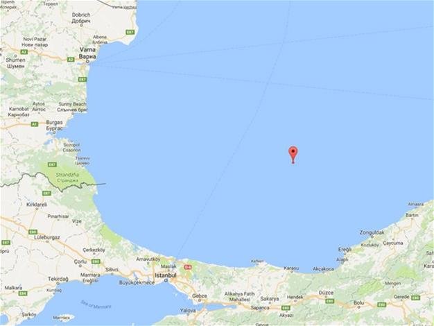
An earthquake with a magnitude of 4.8 magnitude struck Black Sea on Oct. 15 and was felt in Istanbul.
A magnitude 5.0 earthquake occurred in the Black Sea and was felt in the Istanbul province and other northwestern provinces, at 11:18 a.m. on Saturday.

The quake occurred 192 kilometers northeast of Istanbul and 11.4 kilometers below the surface level according to Boğaziçi University's Kandilli Observatory and Earthquake Research Institute, which said the earthquake's magnitude was 4.8.

The European-Mediterranean Seismological Centre (EMSC) stated that the magnitude was 5.2, whereas the United States Geological Survey (USGS) said the magnitude was 5.3.

Some locals were panicked due to the active seismic history of the region.

Seismograph

Earthquake of magnitude 5.8 strikes off Papua New Guinea

Chart
© Reuters
An earthquake of magnitude 5.8 struck 182 km (113 miles) southeast of Rabaul in the Pacific nation of Papua New Guinea, on Wednesday, the United States Geological Survey (USGS) said.

It was initially reported as magnitude of 5.9.

There was no immediate tsunami warning, or reports of damage or casualties from the quake, which struck at a depth of 57 km (35 miles).

Source: Reuters

Seismograph

Shallow 4.8 earthquake off the coast of Oregon

Chart
© Reuters
4.8 magnitude earthquake

2016-10-09 19:08:47 UTC

UTC time: Sunday, October 09, 2016 19:08 PM

Your time: 2016-10-09T19:08:47Z

Magnitude Type: mb

USGS page: M 4.8 - Off the coast of Oregon

USGS status: Reviewed by a seismologist

Reports from the public: 5 people

2016-10-09 19:08:47 UTC 4.8 magnitude, 10 km depth

Comment:


Seismograph

Strong 6.2 magnitude earthquake strikes off eastern Indonesia, no tsunami alert issued

Chart
© Reuters
An earthquake measuring 6.2 Richter scale jolted eastern parts of Indonesia on Sunday evening, but was not potential for tsunami, the meteorology and geophysics agency said.

The quake hit at 21 : 46 p.m. Jakarta time (1446 GMT) with epicenter at 52 km northwest Halmahera of Maluku Utara province, and depth at 117 km under sea bed, an official of the agency told Xinhua by phone.

Indonesia sits on a quake-hit zone so called the "Pacific Ring of Fire," making it vulnerable to quakes.

Source: Xinhua

Info

Scientists find unexpectedly deep seismic activity along California fault

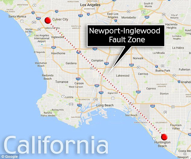
Newport-Inglewood fault
© GoogleResearchers have found that the Newport-Inglewood fault, a major formation that spans the Los Angeles basin, is ‘seismically active down to the upper mantle.’ This is said to be one of the most dangerous faults in the Los Angeles Basin
In Southern California, scientists listening to rumblings deep underground found seismic activity at deeper-than-expected levels, and it may signal new earthquake extremes, according to a new study.

Deeper or smaller seismic activity can be very difficult to monitor, especially in urban areas, due to the distance between seismicity monitors and the noise caused by traffic and industry. In order to better see these so-called micro signals, a group of researchers temporarily deployed detectors along the Newport-Inglewood fault (NIF), which stretches nearly 50 miles (80 kilometers), from Culver City to Newport Beach, in Southern California.

"It's very helpful for us to do these kinds of studies where the seismic risk is high because of the dense concentrations of population," study lead author Asaf Inbal, a geophysics graduate student at the California Institute of Technology, told Live Science. "Most of the damage is inflicted by large earthquakes, but these small earthquakes like the ones we observe at NIF occur much more frequently, and their location can be used to highlight active faults and their depth."

By filtering out the noise, the researchers found that activity along the NIF was unusually deep and frequent compared to similar faults in the region. The researchers said these signals could lead to a better understanding of the depths at which earthquakes can occur, and could further illuminate the structure of the fault.

"Many of these micro earthquakes are deeper than expected. They occur below the crust, in the upper mantle, where rocks are usually thought to be too hot to start quakes (mantle rocks are viscous, they deform like very thick honey, without breaking)," co-author Jean Paul Ampuero, a professor of seismology at Caltech, told Live Science in an email. "They are concentrated in what appears to be the deep continuation of the Newport Inglewood fault down into the upper mantle."
Seismograph

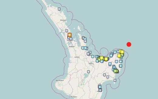
Shallow 'severe' 5.8 magnitude earthquake strikes off New Zealand; part of aftershock sequence

New Zealand earthquake
© GeoNetThe quake was centred 75km out to sea off Te Araroa
This morning's big earthquake off the coast off the East Cape coast is an aftershock of the 7.1 quake that hit a month ago, a GNS seismologist says.

The shallow, 5.8-magnitude earthquake struck about 75km out to sea off Te Araroa, at 8.41am. It was at a depth of 7km.

The quake, rated 'severe' by GeoNet, was widely felt along the North Island's east coast and as far north as Kerikeri, with a scattering of reports in the South Island as well.

Two smaller tremors followed - of 3.1 and 2.8 - centred 20km and 15km from Te Araroa.

Seismograph

Shallow 5.6 magnitude earthquake recorded off the Mariana Islands

Chart
© Reuters
5.6 magnitude earthquake

2016-10-08 18:10:13 UTC

UTC time: Saturday, October 08, 2016 18:10 PM

Your time: 2016-10-08T18:10:13Z

Magnitude Type: mb

USGS page: M 5.6 - 180km NE of Agrihan, Northern Mariana Islands

USGS status: Reviewed by a seismologist

Reports from the public: 0 people

2016-10-08 18:10:13 UTC 5.6 magnitude, 10 km depth

Mariana Islands

Seismograph

Shallow 5.7 earthquake hits off southeast Taiwan

Chart
© Reuters
A shallow 5.7-magnitude earthquake struck off the southeast coast of Taiwan late Thursday, seismologists said, but there were no immediate reports of major damage.

The quake hit 34 kilometres (21 miles) east-southeast of Taitung City at 11:52 pm (1552 GMT), the US Geological Survey said.

Taiwan's Central Weather Bureau measured it at a stronger 6.0 magnitude at a depth of 20 kilometres.

The quake caused short power outages and toppled goods from shop shelves, photographs posted on the Central News Agency website showed, but there were no reports of major damage.

Taiwan lies near the junction of two tectonic plates and is regularly hit by earthquakes.

A 6.4-magnitude earthquake in February left 117 dead when an apartment complex collapsed in the southern city of Tainan.

Source: AFP

Bizarro Earth

Newly discovered fault line running parallel to San Andreas in Southern California raises fears of 'the big one'

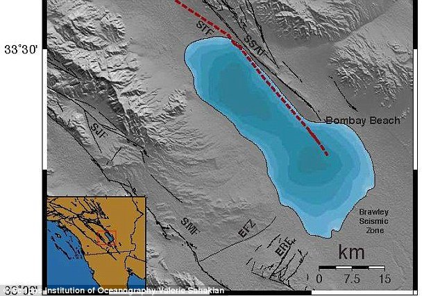
Salton Trough Fault
The new Salton Trough Fault, which runs parallel to the San Andreas Fault, could impact the earthquake-prone region that includes the greater LA area, seismologists say. It is in an area where a swarm of nearly 200 small earthquakes hit last week, raising concerns they might trigger a larger earthquake on the southern San Andreas Fault.

Researchers have revealed a newly discovered fault line running parallel to the San Andreas fault in Southern California.

The new Salton Trough Fault, which runs parallel to the San Andreas Fault, could impact current seismic hazard models in the earthquake-prone region that includes the greater Los Angeles area, seismologists say.

The newly identified strike-slip fault within the Salton Sea, just west of the San Andreas Fault, is in an area where a swarm of nearly 200 small earthquakes hit last week, raising concerns they might trigger a larger earthquake on the southern San Andreas Fault.


Seismograph

3.5 magnitude earthquake hits Pawnee, Oklahoma; site of last months record-setting temblor

Graph
© Dimas Ardian, Getty Images
A 3.5-magnitude earthquake struck northern Oklahoma on Tuesday morning, hitting the same spot where a record-setting temblor was centered a month ago.

The U.S. Geological Survey says Tuesday's earthquake hit shortly after 4 a.m. with an epicenter about 10 miles northwest of Pawnee, or about 75 miles northeast of Oklahoma City. There are no reports of damage or injury.

On Sept. 3, Oklahoma's strongest earthquake on record struck Pawnee and was felt widely throughout the central United States. Scientists later said the 5.8-magnitude quake led to the discovery of a new fault line, leading to worries that oil and gas production could trigger more powerful earthquakes.

Scientists have linked Oklahoma's sharp increase in earthquakes in recent years to the underground injection of wastewater during oil and gas production.

Comment: 5.6 magnitude earthquake, strongest in state history, rattles Oklahoma early Saturday - revised to 5.8! (UPDATE)