Earthquakes
S


Seismograph

Shallow magnitude 5.3 earthquake strikes off Davao Occidental, Philippines

Earthquake graph
A magnitude 5.3 earthquake struck off Davao Occidental before midnight on Thursday, the Philippine Institute of Volcanology and Seismology (Phivolcs) said.

The quake's epicenter was located 63 kilometers southeast of Don Marcelino, Davao Occidental. The quake struck at 11:21 p.m.

The quake, which was tectonic in origin, struck at a depth of 10 kilometers.

The quake is not expected to cause serious damage to properties. No aftershocks are likewise expected.

Earthquake epicentre

Bizarro Earth

6.4 magnitude earthquake rattles Chile

Santiago Earthquake
© USGS
A 6.4 magnitude quake rattled Chile with an epicenter located close to its border with Argentina on Friday, according to earthquake monitors. Witnesses told Reuters that buildings were shaking in the city during the event.

The quake was a "major" event centered in the capital and central Chile, the country's emergency office Onemi is cited by Reuters as saying.

However, Chile's navy said the earthquake doesn't meet the criteria to pose a tsunami threat.

The epicenter of the 6.4 magnitude quake was located 175 kilometers south of Santiago at a depth of 80 kilometers, the European-Mediterranean Seismological Centre said.

The US Geological Survey put the quake's magnitude at 6.3, reporting that it hit 41 miles from Santiago at a depth of 116 kilometers.

Hardhat

Recent Oklahoma earthquakes may finally induce regulators to restrict fracking

earthquake oklahoma Sept 2016
A 4.5 magnitude earthquake that struck northern Oklahoma may have shaken some sense into lawmakers considering increasing restrictions on some oil and gas activity in the state.

Oklahoma's recent increase in earthquakes has some lawmakers concerned about the possible connection to oil and gas production and the subsequent disposal of underground wastewater. While there was no reported damage from Tuesday's 4.5 magnitude earthquake, a 5.6 earthquake in September set a record for the state and has some residents calling for change.

The Oklahoma Corporation Commission plans a response to Tuesday's earthquake while some state regulators are considering placing new restrictions on oil and gas activity, the Associated Press reported.

However, the Pawnee Nation is not holding its breath for regulators to solve the earthquake problem. In late October, the Pawnee Nation announced its plans to take energy companies New Dominion, Sandridge Exploration and Production, Chesapeake Operating and Devon Energy Production Company to court, the Stillwater News Press reported.

Comment: See:


Seismograph

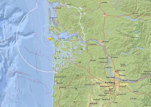
3.8 magnitude earthquake hits off Oregon coast

Quake map Astoria, Oregon
© USGSThe U.S. Geological Survey reported an earthquake, potentially 3.8 in magnitude, near Warrenton and Astoria on Nov. 2, 2016. The epicenter was measured about 10 miles from Astoria, according to the survey’s Twitter feed. It shook the ground around 7:52 a.m. at more than 21 miles deep into the ocean floor, according to the survey’s website.
The USGS has confirmed a 3.8 magnitude earthquake off the Oregon coast just before 8 a.m. Wednesday.

Callers told NATU News the quake rattled their homes, shaking items hanging or on shelves and moving things around. Twitter users reported feeling the quake for a radius extending several miles.

According to the USGS mapping tool, the 7:52 a.m. quake was centered near the coast about 10 miles west of Astoria at a depth of around 21 miles.

The USGS intensity map indicates the quake, naturally, was much stronger near its center by the coast, and its effect weakened in areas farther inland.

The quake was not a Cascadia Subduction Zone earthquake, and instead an isolated event on one of the numerous other faults in Oregon and Washington, USGS officials said.

They added that earthquakes must be magnitude 7.0 or above to create a tsunami.

Comment: The really big one: The next full Cascadia rupture will spell the worst natural disaster in North American history


Hardhat

Oil production may have caused several of California's major earthquakes in early 20th century

1933 earthquake los angeles, oil production earthquakes
Southern California suffered a number of big earthquakes in the early 1900s, a pattern that prompted experts to declare the state an earthquake hazard. But new work shows some of the biggest temblors might have been caused by oil and gas production, not nature. The finding could ultimately change scientists' predictions for earthquakes in the Los Angeles Basin, and how well they understand man-made, or "induced," earthquakes around the country.

It is challenging enough for scientists to determine whether a modern-day quake is natural or induced, and even more so for one that occurred a hundred years ago. The tools they now use to measure earthquakes were not as sophisticated back then, and historic records are limited. So researchers Susan Hough and Morgan Page at the U.S. Geological Survey relied on a combination of old scientific surveys, crude instrumental data and newspaper accounts to piece together details of quakes in the early 20th century. "It's not as precise as having seismic data, but that doesn't mean it's hopeless," Hough says.

Seismograph

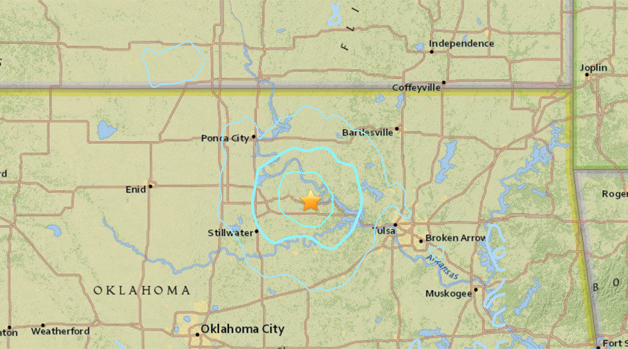
4.5 magnitude earthquake strikes near Pawnee, Oklahoma

Wichita earthquake map
© earthquake.usgs.gov
A 4.5 magnitude earthquake in Oklahoma shook some residents in the Wichita area late Tuesday night.

Residents in the Delano district, College Hill, Riverside, north, south and northwest Wichita said on Twitter that they felt it.

Kenneth Woodard e-mailed The Eagle and said: "Felt the bed sway back and forth several times... It was pretty shaky! Nothing fell off the shelves." He said he lives near Edgemoor and 13th.

The U.S. Geological Society initially reported on its website that a 4.1 magnitude earthquake occurred at 11:26 p.m. near Pawnee, Okla. Pawnee is about 90 miles north of Oklahoma City. It later upgraded it to a 4.5 magnitude.

According to the geological society's site, the quake was felt in Arkansas, Missouri and Texas. Besides Wichita, Kansas towns reporting include: Colwich, Derby, Fort Riley, Salina, Haysville, Pratt, Inman, Overland Park, Lawrence, Hutchinson, Hesston, Pittsburg, Topeka and Kansas City.
Comment: It was the fifth earthquake of the day in Oklahoma according to the United States Geological Survey. A couple of months ago
a 5.8 magnitude earthquake struck near Pawnee, the strongest in the state's history.


Attention

Nearly 20 micro-quakes hit near Salton Sea, California; second swarm in two months

The San Andreas Fault near the Salton Sea.
© Los Angeles TimesThe San Andreas Fault near the Salton Sea.
A series of small earthquakes struck near the Salton Sea area overnight.

Nearly 20 micro-quakes — the strongest measuring magnitude 3.3, with others much smaller — struck the town of Niland near the eastern shore of the Salton Sea, according to the U.S. Geological Survey. A magnitude 3.6 quake was recorded near Salton City on the west side of the Salton Sea.

In September, a series of more than 200 small quakes hit the area. That prompted scientists to say for several days that there was an elevated risk for a big San Andreas fault earthquake. Many of the minor quakes were located under the sea itself.

The Salton Sea is one of California's most seismically complex areas. It is located on a web of faults that scientists fear could one day wake up the nearby San Andreas from its long slumber.

Comment: Recent earthquake swarm under California's Salton Sea could lead to massive earthquake on San Andreas fault


Bizarro Earth

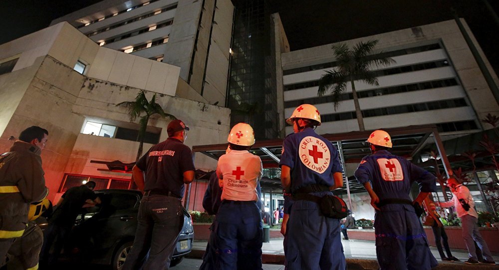
Magnitude 5.4 earthquake hits Colombia

Colombia Earthquake
© Reuters/Jaime SaldarriagaRescue team members wait outside a clinic that was evacuated after tremors were felt resulting from an earthquake in Ecuador, in Cali, Colombia, April 16, 2016
An earthquake measuring 5.4 on the Richter scale occurred on Monday in the center of Colombia, the US Geological Survey (USGS) reported.

Moscow — The earthquake occurred at 00:20 GMT on Monday at a depth of 44 kilometers (about 27 miles) with the epicenter located in 25 miles of the small town of Colombia. The largest urban center relatively close to the earthquake at approximately 67 miles was Neiva with the population of 352,855.

There have been no reports yet of the damage inflicted by the earthquake.

Seismograph

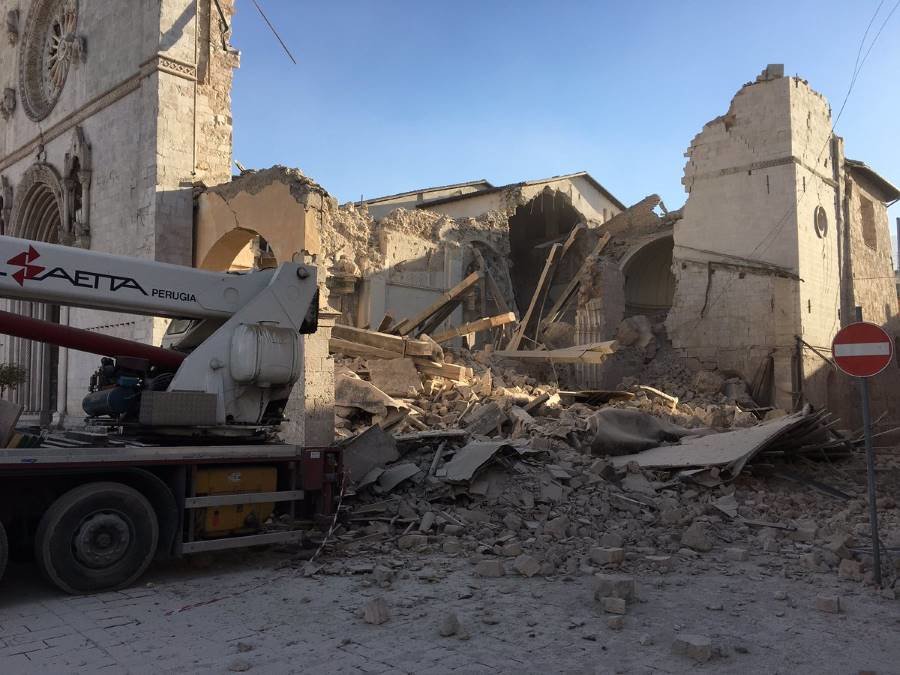
6.6 earthquake devastates historic churches and buildings in Norcia, Italy

norica italy earthquake 2016
© The Monks of NorciaThe Basilica of St. Benedict is destroyed, flattened by most recent earthquake.
The ancient town of Norcia in central Italy is in ruins following the powerful earthquake which knocked its historical 13th century Basilica of St Benedict and other buildings to the ground.

Sunday's earthquake was the latest in a series of seismic events to strike central Italy, and comes just two months after another violent earthquake hit the same area of central and southern Italy, killing 300 people and destroying several towns.


There was widespread devastation, with many buildings, already compromised by earlier quakes, suffering severe damage.

Many of the town's residents had been evacuated after quakes on Wednesday, meaning they avoided the worst of the damage. The Civil Protection agency reported several injuries but no fatalities.

Seismograph

Strong 7.1 magnitude earthquake hits central Italy, tremors felt in Rome- USGS

Map of Italy
© usgs.gov
A powerful 7.1 magnitude earthquake has hit central Italy, Reuters reports citing the United States Geological Survey and local broadcasters. This comes only three days after two more tremors shook the region on Wednesday, leaving villages partly destroyed.

There were no immediate reports on damage or casualties caused by the quake.

However, local RAI TV reports that the tremor was powerful enough to wake the residents of the capital Rome, who reported walls of buildings shaking.

Initial reports on the magnitude of the tremors varied - while the USGS and Italian media talked of a 7.1 earthquake, the European-Mediterranean Seismological Center (EMSC) said the tremor was magnitude 6.5 or 6.6.

The USGS reports the quake was centered 68 km (42 miles) east-southeast of the city of Perugia and 132 kilometers northeast of Rome. The epicenter lay some 108 kilometers deep.