Secret HistoryS


Info

Impressive circular Neolithic building discovered in Cyprus

Aceramic Neolithic site discovered in Cyprus. The announcement followed the completion of the 2019 archaeological mission of the Aristotle University of Thessaloniki in Troodos mountains.

Aceramic Neolithic site discovered in Cyprus
Cyprus Discovery
© Arkeolojik Haber
Republic of Cyprus Department of Antiquities of the Ministry of Transport, Communications and Works has announced the completion of the 2019 archaeological mission of the Aristotle University of Thessaloniki (AUTH) in Troodos mountains.

The team, under the direction of Professor Nikos Efstratiou, consisted of undergraduate and postgraduate students of the Archaeology Section of the AUTH History and Archaeology Department and Cypriot researcher Demetris Kyriakou.
Circular Structures in Cyprus
© Arkeolojik Haber
This year, the site of Agios Ioannis/Vretsia-Upper Rhoudias a site in the upper part of Xeros River terrace in an upland area of Pafos District (elevation: 460 m.), which was first discovered during the 2018 excavation season, was further investigated

The 2019 excavations revealed an impressive circular building which belongs chronologically to the so-called 'Choirokoitian Phase' (ca. 6400 - 5600 BC). The stone building has a diameter of at least 5 meters and is extremely well-built (consisting of two lines of stones).

Sherlock

Çatalhöyük: The 9,000 year old community troubled by climate change, over crowding and infectious diseases

catalhoyuk
© Stipich Béla. Wikimedia CommonsÇatal Hüyük excavations.
Some 9,000 years ago, residents of one of the world's first large farming communities were also among the first humans to experience some of the perils of modern urban living.

Scientists studying the ancient ruins of Çatalhöyük, in modern Turkey, found that its inhabitants - 3,500 to 8,000 people at its peak - experienced overcrowding, infectious diseases, violence and environmental problems.

In a paper published June 17, 2019 in the Proceedings of the National Academy of Sciences, an international team of bioarchaeologists report new findings built on 25 years of study of human remains unearthed at Çatalhöyük.

Comment: See also:


Russian Flag

Soviet dissidents' enemy No.1: KGB general Bobkov dies in Moscow

Bobkov
© Sputnik / Sergey PyatakovFilipp Bobkov in 2005.
Gen. Filipp Bobkov, a veteran of Soviet counterintelligence whose job at the KGB involved quashing dissidents and preventing flare ups of ethnic tensions, has died in Moscow aged 93.

Bobkov passed away at a Moscow hospital after a lengthy ailment, his family and friends told Russian media on Monday. A retired four-star general, he was a controversial figure in Russian history, serving as head of what was essentially the secret police responsible for tackling genuine threats to the USSR, but also blatant persecution of its dissidents. In his later years, he worked for a media tycoon Vladimir Gusinsky.


War veteran

His intelligence career started in 1945 with an appointment to a school of Smersh, the Soviet military organization, the name of which literally means "death to spies." At the time he was a 20-year-old man who had to lie about his age to enroll as a volunteer shortly after the Nazi invasion and rose to a decorated platoon commander on the battlefield. He graduated as an officer and investigator for the Ministry of State Security, which was what the contemporary incarnation of the soviet state security apparatus was called.

Key

Did red-haired, cannibalistic giants exist? Unlocking Lovelock Cave

Inside Locklock Cave
© Dave Feliz

Part One: The Oral Tradition and Written Account

The Oral Tradition


The northern Paiutes of Nevada have an ancient oral tradition that they have passed down from generation to generation that usually causes the hearer to pause in bewilderment. The Paiutes state that long ago in ages past they went to war against a ferocious enemy known as the "Si-Te-Cah" or "Saiduka."

Now, here is where this prehistoric tale becomes fascinating. According to the Paiutes, the Si-Te-Cah were a race of red-haired cannibalistic giants that would literally devour the flesh of their foes! The chronicle states that after three years of blood-weary-battles, a coalition of regional tribes finally unified together to conquer this savage enemy. The allied tribes bravely pushed the Si-Te-Cah back into the depths of a very large cave and quickly covered the entrance with brush piles. A fire was then set ablaze that began to suffocate the giants and any would-be escapees were quickly shot with a fury of fire-piercing arrows. The giant cannibalistic carnivores finally met their grim fate in a blazing cavernous inferno.

"Si-Te-Cah" is said to be translated as "Tule-Eaters" in the northern Paiute language. Tule is a species of water plant that grows in marshes across North America and would have grown in "Lake Lahontan," a Pleistocene lake that once covered much of northwestern Nevada around 12,700 years ago. According to the oral tradition, the giants used the tule to weave rafts in which to navigate the lake, flee surprise attacks from the Paiutes and worst of all - capture the Paiute women who would gather tule near the shore of Humboldt lake. [1]

Info

Archaeologists uncover unique megalithic monument in Ireland

Archaeology Students
© IT SligoIT Sligo Archaeology students Jazmin Scally Koulak and Eugene Anderson sieving the soil at Carrowmore excavation.
An archaeological excavation in Co Sligo has uncovered a megalithic monument thought to be unlike any found in Ireland to date.

Several prehistoric tools made from a hard stone called chert were discovered and are thought to have been used for activities such as working animal hides, cutting and preparing food, basket food, basket working and bone working.

The discovery was made by a team of archaeologists from IT Sligo during a two-week excavation of a prehistoric monument in the heart of the Carrowmore megalithic complex in Co Sligo.

Carrowmore in the largest cemetery of megalithic tombs in Ireland, with 5,500-year-old passage tombs dating from 3,600 BC.

Info

8,000-year-old carvings by ancient humans discovered in South Africa

Ancient Petroglyphs
© University of the Free StateOne of the carvings found on the impact crater dyke.
Two billion years ago an enormous asteroid slammed into what is now South Africa. It left behind the largest and second oldest confirmed impact crater, the 300 kilometer-wide (190-mile) Vredefort Crater. The distinctive crater shape has eroded away over the course of almost half the Earth's lifetime, but its legacy remains important. Geologists studying the crater have found stone carvings showing it was a place of considerable spiritual significance to ancient peoples, as well as making possible the world's richest gold mines.

The Vredefort Crater is almost twice the size of the one at Chicxulub that ended the Cretaceous Era. The asteroid that made it is thought to have been much larger as well - some 10 to 15 kilometers (6 to 9 miles) across. Despite the geological forces that have acted on it we can still make out features such as its central dome, parts of the crater rim and deformed rock that once lay below the crater floor. The site provides us with a rare opportunity to study a very large impact site without having to go to the Moon.

Geologists from South Africa's University of the Free State are in the process of investigating it, and while much of their work is still to be done, they have already come up with some exciting findings outside their fields.

The floor of the crater is marked by granophyre dykes, feldspar and quartz rocks that can stretch for miles while being only a few meters wide. A paper in Geology concludes molten material produced in the impact sank into the ground and captured rock fragments on its descent that would otherwise have eroded away over the subsequent billions of years. To geologists, these are a rich source of information about ancient rock formations that would otherwise have been lost.

Marijuana

Oldest evidence of marijuana use discovered in 2500-year-old cemetery in peaks of western China

cannabis
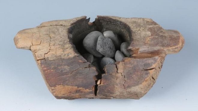
© XINHUA WUAncient people put cannabis leaves and hot stones in this brazier, and likely inhaled the resulting smoke.
Today, more than 150 million people regularly smoke cannabis, making it one of the world's most popular recreational drugs. But when and where humans began to appreciate the psychoactive properties of weed has been more a matter of speculation than science. Now, a team led by archaeologists Yang Yimin and Ren Meng of the Chinese Academy of Sciences in Beijing reports clear physical evidence that mourners burned cannabis for its intoxicating fumes on a remote mountain plateau in Central Asia some 2500 years ago.

The study, published today in Science Advances, relies on new techniques that enable researchers to identify the chemical signature of the plant and even evaluate its potency. "We are in the midst of a really exciting period," says team member Nicole Boivin of the Max Planck Institute for the Science of Human History (MPI-SHH) in Jena, Germany. The paper is part of a wider effort to track how the drug spread along the nascent Silk Road, on its way to becoming the global intoxicant it is today.

Cannabis, also known as hemp or marijuana, evolved about 28 million years ago on the eastern Tibetan Plateau, according to a pollen study published in May. A close relative of the common hop found in beer, the plant still grows wild across Central Asia. More than 4000 years ago, Chinese farmers began to grow it for oil and for fiber to make rope, clothing, and paper.

Comment: See also:


Map

Crannogs: Neolithic artificial islands in Scotland stump archeologists

Ustan vessel
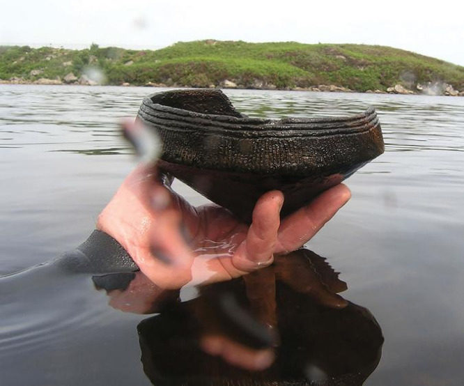
© C. MurrayA diver holds a Neolithic (ca. 3,500 B.C) Ustan vessel found near a crannog (artificial island) in Loch Arnish, Scotland.
When it comes to studying Neolithic Britain (4,000-2,500 B.C.), a bit of archaeological mystery is to be expected. Since Neolithic farmers existed long before written language made its way to the British Isles, the only records of their lives are the things they left behind. And while they did leave us a lot of monuments that took, well, monumental effort to build-think Stonehenge or the stone circles of Orkney-the cultural practices and deeper intentions behind these sites are largely unknown.

Now it looks like there may potentially be a whole new type of Neolithic monument for archaeologists to scratch their heads over: crannogs.

Artificial islands commonly known as crannogs dot hundreds of Scottish and Irish lakes and waterways. Until now, researchers thought most were built when people in the Iron Age (800-43 B.C.) created stone causeways and dwellings in the middle of bodies of water. But a new paper published today in the journal Antiquity suggests that at least some of Scotland's nearly 600 crannogs are much, much older-nearly three thousand years older-putting them firmly in the Neolithic era. What's more, the artifacts that help push back the date of the crannogs into the far deeper past may also point to a kind of behavior not previously suspected in this prehistoric period.

Comment: A 2016 report from the BBC provides more detail about the construction and possible uses of the crannogs:
crannog
© AlamyBarrie Andrian and Nick Dixon’s reconstruction of an ancient crannog was built without any metal, including bolts or nails
Known as "crannogs" and build in lakes or lochs, some of these fortified islands date back as far as 5,000 years ago. Unlike similar constructions found in the European Alps - which were built on land that only flooded in later centuries - crannogs were always built to be artificial islands.

Supported by piles driven into the lake bed, some have several roundhouses on them. The more popularly recognised version is a single roundhouse on a platform. And they are unique to Scotland and Ireland. In Scotland, more than 350 have been confirmed, though the actual number could be far greater.

Despite the number of crannogs, archaeologists say that finding one can be like discovering a treasure chest. That is because, since most of these prehistoric dwellings are now completely underwater, they have often survived better than if they had been exposed on land - sometimes still retaining even the bracken that covered the floor.

"It's very exciting," says Nick Dixon, director and founder of the Scottish Trust for Underwater Archaeology, who with Barrie Andrian leads the excavation of Oakbank crannog on Loch Tay in Kenmore, Scotland. "You're lying on an Iron Age person's house floor after 2,500 years; there are bracken and ferns, still absolutely identifiable."

Started in 1980, the Oakbank dig was the first underwater excavation of a crannog in Scotland. Today, it is only about halfway through.

crannogs
© AlamyLoch Tay alone holds the remains of 18 known crannogs; the one shown here is a reconstruction at the Scottish Crannog Centre
Oakbank is hardly alone. It is just one of 18 crannogs that have been surveyed in 13-mile-long Loch Tay alone.

"Their construction recreates the original crannog as best they can"

But Loch Tay is not unusual. Beneath their surface, many of Scotland's lochs hide the remains of a dozen crannogs or more, most of them dating to the same eras - around either the 5th or 2nd Centuries BC.

The number of crannogs is remarkable because building a crannog is not an easy task. Dixon and Andrian know because they did it themselves, creating Scotland's only reconstructed prehistoric crannog at the Scottish Crannog Centre.

Set further down Loch Tay from their Oakbank excavation, their construction recreates the original crannog as best they can by drawing on findings they have made from the dig. Where they have not found evidence yet - for instance, for a roof - they have relied on outside sources and experimentation to see what works.

There is one key difference from the original: to make it accessible for visitors, there is a small bridge that leads to it from the shore. Other than that, Andrian and Dixon have tried to remain as true to its original structure as they can.

"There is no metal in the entire recreated structure"

However, it is important to note, as researchers like Graeme Cavers of AOC Archaeology have pointed out, that even if it their reconstruction were completely accurate, it could only show a crannog as it was at a single point in history. Most crannogs, including Oakbank, were re-used off and on for the next 2,500 years. One example lies just across from the reconstructed crannog on Loch Tay: Priory Island, which was reused in the 12th Century as a priory and today is completely wooded.

What is remarkable is how comfortable the crannog is.

While it looks small from the outside, inside it seems to open up. Andrian and Dixon estimate that some 20 or so people, likely an extended family, would have lived within a crannog of this size.

The roof is thatched. Bracken and ferns provide a prehistoric version of plush carpet. Furs are draped over low benches, and a hearth in the middle would have provided warmth and light.

There is no metal in the entire recreated structure, meaning no iron nails, screws, bolts or cables. Instead, everything is made from wood and organic materials.
crannog
© The Scottish Crannog CentreAlthough the reconstructed crannog looks small from the outside, inside it seems to open up
Because it is a pleasant day, the other benefit of the crannog is less immediately obvious: it is an ideal design for the Scottish climate. The conical roof is aerodynamic, and since the structure is made of timber, the whole settlement moves and flexes, a particularly important feature for an area that can see 100mph winds and pounding waves from the loch.

Building that kind of dwelling requires a high level of skill. It also needs abundant resources.

The reconstruction needed enough straight trees for 168 individual timber piles drilled into the loch bed, not to mention the entire structure above.

"We learned pretty quickly that getting raw materials was an issue: where do you get lots of nice, straight trees? If you look around here, you see there are lots of nice straight trees - alder trees," Dixon says, gesturing to the thick forest that surrounds the loch. "And that's exactly what people used. So we realised we had to cut these trees down in the winter, and start building in the springtime. If you ran out, you didn't want to go cutting trees in the summer. And this has been held up with evidence from other sites."

It is impossible to know just how long it would have taken these early settlers to build their crannogs. On the one hand, they were cutting down trees with bronze axes that blunted easily; on the other hand, they would have been honing their skills since they were children.

In some ways, it does not matter. "What you've got to remember is that their whole mindset is a million miles away from ours, mainly because they're not watching the clock; they're watching the seasons," Dixon says. "Nobody's coming and saying, 'Oh, it's 10 o'clock'. But it would have taken quite a long time."

Which leads to the main question: why did they go to all of this trouble in the first place?

Given the number and the diversity of crannogs, researchers say that there is no single answer. But because all crannogs are set off from land - often with a gate, or some kind of other barrier, at one end - most researchers are comfortable saying they were built to be defensive, even if they were rarely used for actual warfare.

The main giveaway that crannogs were not entirely meant for military use is their highly visible location.

"Nobody's hiding away here," says Dixon. "If you go 10 miles up the loch on the road, you can look down and see this on a sunny day. So no one's hiding. They're saying, 'We're the people that live here. Want to come and fight with us?'"

In that sense, the crannogs may be a little like the mysterious hill forts of Wales, which appeared around the same period. They were probably built partly to be a stronghold in case of attack but, equally, to look like they would be a stronghold in the case of attack. In other words, to impress everyone else.

Crannogs "represent a highly visible imprint on the landscape, clearly designed to look impregnable but also making a statement of presence," writes Cavers in his paper "Crannogs as buildings: The evolution of interpretation 1882-2011". And it is not just crannogs: "Through the later first millennium BC, domestic architecture became the principal investment of farming communities, standing in stark contrast to the monumental communal tombs and stone circles of earlier centuries."

But if this idea is true, it raises the question of why people began paying more attention to defence or status at this specific time.

crannog
© AlamyPriory Island, the wooded island shown on the right, has was at least partly man-made by ancient people
In Loch Tay, of the 13 crannogs that have been radio-carbon-dated, nine date back to the same period as Oakbank. Four others seem to have been built 2,400 and 1,800 years ago. Those two spikes in activity - one in the mid-first millennium BC, the second toward the end of the millennium - echo a trend seen throughout Scotland.

In part, this may have stemmed from the same reason that caused a boom in Welsh hill forts in the same period: climactic deterioration.

Around 536 AD, there was a well-documented catastrophe - likely caused by one if not two volcanic eruptions, or perhaps a series of comet impacts - that covered the Northern Hemisphere in a haze of dust. This caused crops to fail and made it colder and wetter. After another volcanic eruption around 210BC, when another dust veil appeared, the climate worsened again.

As researchers Mike Baillie and David Brown, among others, have pointed out, these events line up with a spike in building crannogs in both Ireland and Scotland.

crannog
© Science Photo LibraryUnlike the crannog at Loch Tay, this reconstructed settlement at the Craggaunowen Project in Ireland is an artificial island with several houses
"In an area like this, even a change of a few degrees means people have to move down from the higher lands," where cut rocks and stone circles point to earlier inhabitants, says Dixon.

"With so many crannogs in the loch, there are so many answers that are just waiting to be discovered"

At Loch Tay alone, he adds, "We think around 500 people are moving down to the loch side. Because of pressure on land, people are being more defensive. And these crannogs are defensive settlements."

Andrian and Dixon are hoping that the continued excavation of Oakbank may provide a clearer picture. But, as the centre and excavation are entirely self-funded, they are limited in what they can do - particularly in terms of expanding to any of the other sites in the loch.

"It's kind of frustrating that we're not able to get in, and do more, and train more people to get involved and carry on the research," Andrian says. "With so many crannogs in the loch, there are so many answers that are just waiting to be discovered."

Although there is a discrepncy between the dating for when the crannogs may have been built, the reason for doing so may have been the same, see:


Dig

Mysterious flooding leads to discovery of 5,000-year-old underground city in Turkey's Cappadocia

Cappadocia
© DHA Photo
A underground city partly submerged underwater and estimated to be around 5,000 years old was discovered by municipality crews trying to determine the cause of flooding in several houses in the Avanos district of Turkey's central Nevşehir province, located at the heart of the historic Cappadocia region.

Owners of some 15 houses in the Çalış township of Avanos, which is inhabited by 2,200 people, informed the local municipality that their houses were filling up with water and they could not figure out why or where the water was coming from.

Municipality crews started discharging water from the homes while searching for the cause of the flooding, using heavy duty machines to open the entrances of a tunnel closed for safety decades ago and long forgotten by locals. After making more way into the tunnel, crews and locals found an underground city partially covered in clear water, which had caused the flooding, and saw that the houses were situated right on top of the flooded city's rooms and tunnels.

Comment: See also:


Russian Flag

Pristina stand-off: How Moscow blindsided NATO with 'secret Kosovo airport raid' 20 years ago

Pristina airport raid Russian peacekeepers
© ReutersRussian peacekeepers at Pristina airport on June 12.
NATO's bombings of Serbia in 1999 had one small episode that is remembered with glee by many Russians. In a surprise deployment, Russian troops seized a strategic airport near Pristina right under the nose of the British.

Exactly 20 years ago, Russian troops deployed to Bosnia and Herzegovina as part of the UN-mandated peacekeeping Stabilization Force (SFOR) executed a highly secretive operation. Amid a training exercise outside their base, 15 BTR-80 armored personnel carriers, two dozen support vehicles, and 200 paratroopers sneaked out and sped southeast.

Their destination was over 600km away in Kosovo, the breakaway Serbian region that was about to gain independence from Belgrade on the back of NATO's three-month bombing campaign. The Serbs were defeated and agreed to retreat while NATO troops were preparing to move in. The Russians were racing against them and militants of the Kosovo Liberation Army to take control of Slatina Air Base, the only airfield in Kosovo suitable for large military transport planes.