
Extreme Temperatures
S


Snowflake Cold

South Brazil state Santa Catarina records 3rd consecutive day of rare snow, below-zero temperatures

snow

Santa Catarina recorded snow accumulations in Urupema and Sao Joaquim early Wednesday morning, June 30, the third consecutive day of the rare phenomenon including below-zero temperatures.

According to the Information Center of Environmental Resources and Hydrometeorology of Santa Catarina (Epagri / Ciram), this is the first year since 2000 that such a meteorological event has been recorded three consecutive days.

Since the beginning of the week, the humidity and temperature conditions favored the appearance of snowflakes in the cities located in the region of the Santa Catarina Mountains.

Cars, lawns, and roads were covered by a layer of ice on Wednesday. Also, according to Epagri / Ciram, in Bom Jardim da Serra, at 3 AM, the temperature reached -3.9° C.

Around 5 AM the minimum in Urupema was -3.45° C. In the same region, thermometers showed -2.13° C in Urubici and -1.6° C in São Joaquim at around 3 AM.


Bullseye

AccuWeather meteorologist: Global warming not to blame for Northwest's heatwave

AGW fraud


Record heat has been felt across the the Pacific Northwest this week, which has led the MSM and their placard-brandishing, sandal wearing EOTW groupies to draw the connection to 'global warming' aka 'the climate crisis' aka 'terrifying terra firma broiling'.


However, AccuWeather Meteorologist Joe Lundberg is on the record as saying that AGW isn't to blame here.

Risking a backlash from his bosses, and from those faceless elites on high, Lundberg very reasonably states: "I just think that right now we're seeing a very unusual pattern across most of the northern hemisphere where there's a lot of extremes."

Lunberg sees erratic jet streams as the main culprit here, which, as Electroverse has been saying for years, are weakening due to historically low solar activity — and while Lunberg doesn't touch on solar output, he does reference a "big upper level trough that's in the Aleutians".

Right now, weather patterns across the country are very unusual, explains Lundberg: "Downstream, there's a massive upper level ridge that's in the Northwest, that's why they're seeing the record heat there.

Snowflake Cold

Adapt 2030 Ice Age Report: Avoid the cold in record heat

North America temp extremes
© YouTube/Adapt 2030 (screen capture)
Incredible heat records broken as the new Eddy Grand Solar Minimum intensifies, but at the same time all time record ice gain on Greenland and well outside the norm cold events through June that never made any front page. Balance would be nice, so here is what wasn't reported, get out the hand warmers.


Comment: A record amount of snow and ice was added yesterday in Greenland - 4 gigatons in one day


Sun

Canada weather: Dozens dead as heatwave shatters records - temperature hits 49.6C (121.3F)

cool
Dozens of people have died in Canada amid an unprecedented heatwave that has smashed temperature records.

Police in the Vancouver area have responded to more than 130 sudden deaths since Friday. Most were elderly or had underlying health conditions, with heat often a contributing factor.

Canada broke its temperature record for a third straight day on Tuesday - 49.6C (121.3F) in Lytton, British Columbia.

The US north-west has also seen record highs - and a number of fatalities.


Experts say climate change is expected to increase the frequency of extreme weather events, such as heatwaves. However, linking any single event to global warming is complicated.


Comment: AccuWeather meteorologist: Global warming not to blame for Northwest's heatwave


Snowflake Cold

Polar blast grounds flights, shuts highways in New Zealand

A Fulton Hogan truck ploughs snow in Taieri Rd this morning.
© Stephen JaquieryA Fulton Hogan truck ploughs snow in Taieri Rd this morning.
Flights were cancelled, highways shut and essential services disrupted as an Antarctic polar blast swept New Zealand on Tuesday, bringing heavy snow, powerful waves and icy temperatures.

The North Island capital city of Wellington was lashed by the worst tidal storms in years, with authorities asking some coastal residents to be ready to evacuate, as large swells were forecast over the next 24 hours.

"Those people whose homes have been impacted by past swell and storm events should be prepared for these potential impacts again," regional emergency authorities said in a website statement.


Snowflake Cold

Polar wave in southern Brazil has the world's largest cold anomaly outside the poles

Global temps map
© Climate Reanalyzer
The polar wave of this first half of the week in the Center-South region of Brazil, Uruguay, Argentina and Paraguay brings the biggest negative cold anomaly in the world outside the poles. Nowhere on the planet are temperatures so below average outside the polar regions as the central part of South America.

There are extensive areas of below-average temperature in the Central Plains of the United States, Northern Canada and central Russia, but outside Antarctica there is no region on Monday with temperatures as below average as the central portion of South America, effect of the powerful polar air mass that covers most of the countries of the Southern Cone of America.

It snowed this morning in Santa Catarina, on the Planalto Sul Catarinense, and frozen rain fell in São José dos Ausentes (RS) and in Pato Branco, in the southwest of Paraná.

Sun

Heatwave in western US, Canada sends temperatures soaring to record highs

People sleep at a cooling shelter set up during an unprecedented heat wave in Portland, Oregon
© REUTERSPeople sleep at a cooling shelter set up during an unprecedented heat wave in Portland, Oregon
A "heat dome" over western Canada and the US Pacific northwest sent temperatures soaring to new highs, triggering heat warnings from Oregon to Canada's Arctic territories on Sunday.

Hotspot Lytton in British Columbia -- about 250 kilometres (155 miles) northeast of Vancouver -- broke the record "for Canada's all time maximum high" with a temperature of 46.6 degrees Celsius (116 Fahrenheit), said Environment Canada.

More than 40 new temperature highs were recorded throughout the province over the weekend, including in the ski resort town of Whistler. And the high-pressure ridge trapping warm air in the region is expected to continue breaking more records throughout the week.

Environment Canada issued alerts for British Columbia, Alberta, and parts of Saskatchewan, Yukon and the Northwest Territories.

"A prolonged, dangerous, and historic heat wave will persist through this week," it said, forecasting temperatures near 40 degrees Celsius (104 Fahrenheit) in several regions, or 10-15 degrees Celsius hotter than normal.

Snowflake

French weather: Floods, tornados, hailstones...and now snow in June

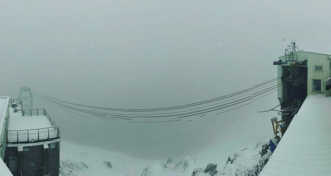
The camera at the top of the Pic du Midi captured the snowfall, which is rarer at the end of June
© Météo PyrénéesThe camera at the top of the Pic du Midi captured the snowfall, which is rarer at the end of June
The summer snowfall in the Pyrenees is the latest in unexpected weather in recent weeks. Forecasters say it is 'not so rare' in the first half of June at high altitude, but less common now.

Snow has fallen late in the season in the Pyrenees, with snowfall reported from 2,700 metres altitude near the Pic du Midi, yesterday (June 23).

The Météo Pyrénées webcam on the famous peak - at 2,800 metres altitude - captured poor weather and considerable snowfall yesterday.

It is the latest in 'extreme' weather in France - following heatwaves, storms, flash floods and tornados across the country in recent days.


Comment: Other recent extreme weather events in the same country include:


Snowflake Cold

Best of the Web: A record amount of snow and ice was added yesterday in Greenland - 4 gigatons in one day

So just when is all this ice going to disappear?
Following a historic increase in snow and ice in late May, Greenland has seen huge gains at a time when it usually lost snow and ice.

If you look at the official figures provided by the Danish Meteorological Institute (DMI), it turns out that yesterday, June 24, 4 gigatons were recorded in one day - an astonishing figure for this time of year: Greenland has never received so much snow and ice in recorded history, so late at the start of the season.

Despite decades of prophecies about the doom of glaciers that are "about" to melt due to "Global Warming", the ice sheet is currently gaining a record amount of "mass" - only for yesterday (June 24, 2021) - 4 gigatons.

There has never been such a large accumulation at this time of year - at least since DMI started recording in 1981. Growth of this magnitude would be considered normal in November-February, but not at the end of June.

Blue Planet

Adapt 2030 Ice Age Report: The signs are unmistakable

noctilucent clouds over Paris
© YouTube/Adapt 2030 (screen capture)
As the second magnetic field in our solar system begins to take shape and strengthen from July / August of 2021 more signs are becoming increasingly visible across the skies, oceans and Earth. These are a dozen examples of hundreds that took place during the same time. Time to get your plan in order.