Earthquakes
S


Alarm Clock

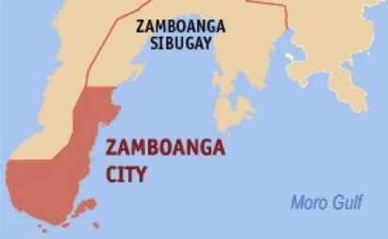
Magnitude 6 earthquake shakes Zamboanga, Philippines

Philippines earthquake map
© Wikipedia
Three people were injured while four houses were partially destroyed early Thursday when a magnitude 6.0 earthquake shook the Zamboanga Peninsula region.

The Philippine Institute of Volcanology and Seismology said the tremor occurred at 2:21 a.m. Thursday and traced its epicenter at 17 kilometers northwest of Baligiuan, Zamboanga del Norte, which also felt the quake at intensity 4.

Dr. Elmeir Apolinario, city disaster risk reduction and management officer, said the victims are all residents of Kalinaw Urban Poor Association in Barangay Sinunuc, 9.30 kilometers west of City Hall.

Apolinario identified the victims as Arcina Natividad, 56, injured in the head; Raymond Natividad, 23, abrasions in the right hand, foot, right shoulder and bruises at the back; and, Juliana Makahibag, 13, hand and head injuries.

The victims were injured when the concrete divider of their house, which is still under construction, collapsed while they were asleep at the living room.

No one was hurt in the three other houses, owned by Natividad's neighbors, damaged by the earthquake.

Intensity 4 was recorded in Baliguian and Labason in Zamboanga del Norte, Dipolog City posted intensity 2, while intensity 1 was recorded in Liloy.

Phivolcs, in its earthquake bulletin posted at 3:47 a.m., warned the public against possible aftershocks.
Attention

Powerful 6.9 magnitude earthquake hits India and Myanmar

Earthquake map
A powerful earthquake, measuring 6.9 magnitude, struck the border of India and Myanmar on Wednesday at 7:25 p.m. local time. Tremors were reportedly felt across the region in Kolkata and as far as Delhi.

The United States Geological Survey reported the magnitude of the earthquake in a tweet and identified it was 74 kilometers (45 miles) southeast of Mawlaik, Myanmar.
Prelim. Report M6.9 - 74km SE of Mawlaik, Burma You can report feeling the earthquake at: http://on.doi.gov/1qHTyzq pic.twitter.com/EjUwVGaqCl


People crowd onto the street during an earthquake in Agartala, capital of India's northeastern state of Tripura, on April 13, 2016.
© AFP/Getty ImagesPeople crowd onto the street during an earthquake in Agartala, capital of India's northeastern state of Tripura, on April 13, 2016.

Attention

Magnitude 5.6 earthquake recorded near Kiska Volcano, Alaska

Alaska 5.6 earthquake
An earthquake with preliminary magnitude of 5.6 has been recorded near Kiska Volcano, Alaska on 11 April 2016 20:10:35. The earthquake epicenter was located at precisely 109km SW of Kiska Volcano, Alaska and at a depth of approximately 28 km. A provisional tsunami alert have been issued for the region following this earthquake. Other details about the earthquake were not immediately available, and there were no immediate reports of damage or casualties. We will update this report as soon as we have more information.

Below is a map showing the location of the earthquake and additional information pertaining to the exact location of the epicenter.

Bizarro Earth

Massive 2015 Alaskan landslide triggering mega-tsunami estimated to be biggest non-volcanic landslide in North American history

landslide tyndall glacier
After a period of heavy rains, about 200 million metric tons of rock tumbled down a remote Southeast Alaska mountain. The massive landslide, lasting about 60 seconds, occurred on October 17, 2015, and landed on the toe of Tyndall Glacier and into Taan Fiord in Icy Bay, Alaska.

The event generated a local megatsunami that sheared trees more than 152.4 meters (500 feet) up on a peninsula within the fiord. It was big enough to register at the nearest tidal gauge 155 km (96.3 miles) away. For comparison, the 2011 tsunami in Japan reached about 39.6 meters (130 feet) above sea level.

This event, now estimated as the biggest nonvolcanic landslide, by volume, in North America's written history, was registered by special seismograms monitored by the Global CMT Project at Lamont-Doherty Earth Observatory whose seismologists Göran Ekström and Colin Stark have invented a new technique that uses seismic waves to detect landslides in remote areas where they might otherwise go unrecorded.

Attention

Magnitude 6.6 earthquake strikes Afghanistan: Strong tremors felt in India and Pakistan capitals

Earthquake map
A powerful earthquake has struck the border area between Afghanistan, Pakistan and India, with tremors felt in Delhi and Islamabad.

The quake was intially measured at magnitude-6.6 and depth 210km by the USGS, though there were no immediate reports of casualties.

Reports from across South Asia described buildings swaying for more than a minute with tremors felt in the Pakistani city of Lahore some 630km from the epicentre.

Pakistani official Arif Ullah said the magnitude-7.1 quake was centered near Afghanistan's border with Tajikistan. Germany's GFZ Research Center for Geosciences set the quake's magnitude at 6.5.

Question

Reports of mysterious tremors in eastern North Carolina attributed to sonic booms from military activity

sonic boom wave map north carolina
© WECTWhat appears to be a sonic boom wave caught on radar.
Did you feel a bit of a shake Friday afternoon? You're not alone.

WECT received several emails and messages on social media about a possible tremor in the Myrtle Grove area, as well as in Leland.

However, the United States Geological Survey's website showed no earthquake activity in North Carolina.

Our First Alert meteorologists did manage to see what appears to be remnants of a sonic boom wave on radar just off the coast of the Cape Fear region.

Info

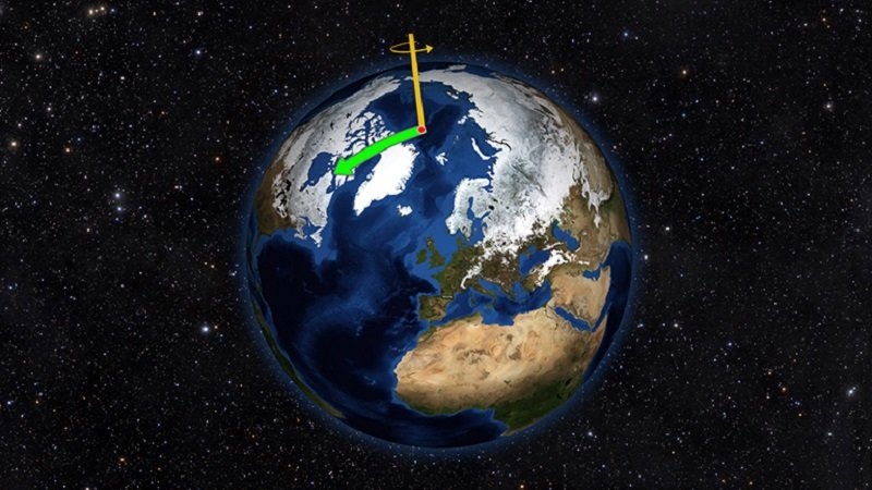
Movement of water around the world contributes to Earth's rotational wobbles says NASA

Earth's Spin Axis
© NASA/JPL-CaltechEarth does not always spin on an axis running through its poles. Instead, it wobbles irregularly over time, drifting toward North America throughout most of the 20th Century (green arrow). That direction has changed drastically due to changes in water mass on Earth.
Using satellite data on how water moves around Earth, NASA scientists have solved two mysteries about wobbles in the planet's rotation -- one new and one more than a century old. The research may help improve our knowledge of past and future climate.

Although a desktop globe always spins smoothly around the axis running through its north and south poles, a real planet wobbles. Earth's spin axis drifts slowly around the poles; the farthest away it has wobbled since observations began is 37 feet (12 meters). These wobbles don't affect our daily life, but they must be taken into account to get accurate results from GPS, Earth-observing satellites and observatories on the ground.

In a paper published today in Science Advances, Surendra Adhikari and Erik Ivins of NASA's Jet Propulsion Laboratory, Pasadena, California, researched how the movement of water around the world contributes to Earth's rotational wobbles. Earlier studies have pinpointed many connections between processes on Earth's surface or interior and our planet's wandering ways. For example, Earth's mantle is still readjusting to the loss of ice on North America after the last ice age, and the reduced mass beneath that continent pulls the spin axis toward Canada at the rate of a few inches each year. But some motions are still puzzling.

Attention

Earthquake strikes major volcano in Iceland

Bárðarbunga
© Rax / Ragnar AxelssonBárðarbunga volcano
There was a major earthquake on the northern edge of the Bárðarbunga volcanic craters at around midnight last night.

The quake measured 4.2 on the Richter scale and is therefore the largest quake to have hit the famous volcano since it stopped erupting in February last year.

According to Bjarki Fries, a natural disasters specialist with the Icelandic met office, the earthquake emanated from 3.5 kilometers underground. Around 15 aftershocks have already been measured, the most powerful of which was a 3.5 quake at 01.00 this morning.

Met office earthquakes specialist Martin Hensch told RÚV that there is no evidence of lava movements or of any eruption activity connected to the earthquakes, but that the situation will be monitored carefully. There were two quakes in the same location on April 3, measuring 3.4 and 3 on the Richter scale.

The recent eruption at Bárðarbunga, often known as Holuhraun, lasted from late August 2014 to late February 2015, and despite not affecting aviation or physically threatening any human settlements, it caused dangerous levels of pollution around Iceland and produced more new lava than almost any other eruption in Iceland since the Vikings first arrived.

Alarm Clock

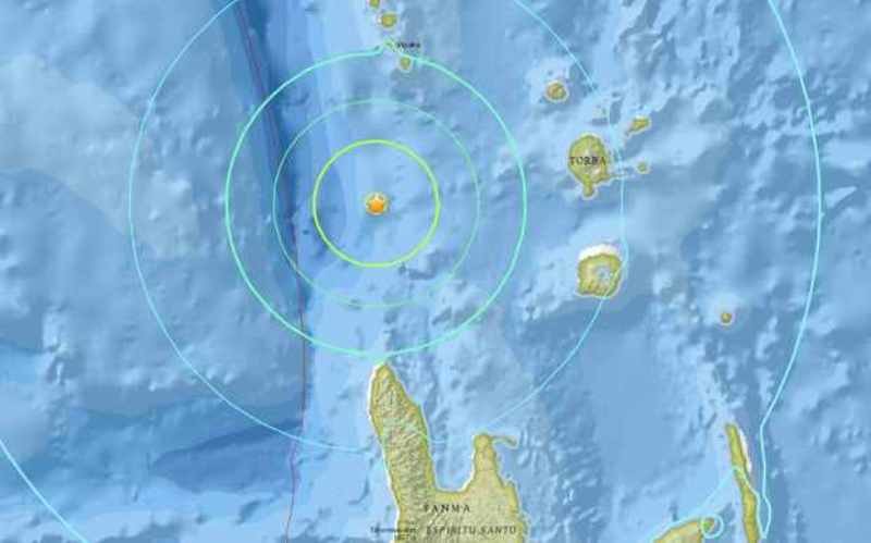
Magnitude 6.7 earthquake strikes Vanuatu; THIRD large quake in region this week

6.7 Vanuatu earthquake
© US Geological ServiceThe epicentre of Thursday's 6.7 magnitude earthquake in Vanuatu's Torba province.
An earthquake measuring 6.7 has struck the northwest of Vanuatu, the third large earthquake in the same region this week.

The United States Geological Service said the earthquake struck 109km west of Sola, in Torba province, at a depth of 33km.

The Pacific Tsunami Warning Centre said the quake posed no tsunami threat.

Thursday afternoon's quake came less than 24 hours after another 6.9 magnitude struck slightly to the west in Santo at a depth of 10km.

Another quake of the same magnitude struck the area on Sunday.

Alarm Clock

Swarm of small earthquakes hit northwestern Arizona

Arizona earthquake swarm
© ABC15/KNXV (screen capture)
A series of small earthquakes swarmed the state's northwest corner after an initial magnitude 2.3 earthquake on the Arizona strip March 29, officials said Tuesday.

The earthquake that struck near Littlefield, Ariz., a community about 20 miles southwest of St. George, Utah, was the first of 18 small-magnitude tremors that lasted through Sunday, according to the Arizona Geological Survey.

The largest event was a 2.6 magnitude quake at about 8:36 a.m. Sunday. The Arizona Geological Survey has not reported any injuries or damage from the series of tremors.

While the amount of quakes to hit the area may seem unusual, Geological Survey researcher Michael Conway said the state has seen swarms before.

Conway said the area is "tectonically active," but this was the first time a swarm has been recorded in the northwest corner of the state, bordering Utah and Nevada.

"Active faults in the vicinity of the earthquake swarm include the Mesquite/Overton Arm," according to an Arizona Geological Survey statement. The area has extensive earthquake history.