Earthquakes
S


Bizarro Earth

USGS: Powerful 5.8-magnitude quake hits Tonga

Tonga earthquake map
© earthquake.usgs.gov
A 5.8-magnitude has hit the coast of the Pacific island nation of Tonga, USGS reported. The tremor with a depth of 66km, struck 287km from the county's capital of Nuku'alofa.

The part of the South Pacific Ocean where Tonga lies is considered to be one of the most seismically active areas in the world due to convergence between the Australia and Pacific plates, the USGS said.

In March, a 6.2-magnitude earthquake struck off Tonga and the Samoa islands, Geoscience Australia and the US Geological Survey (USGS) reported. The quake occurred just 96km from the town of Hihifo in Tonga.

Bizarro Earth

Researchers find cracks in ground near epicenter of Japanese earthquake

Slip after Earthquake
© YouTube Screen Capture
Researchers have found a long tear in the earth near the epicenter of a strong earthquake that jolted the southern Japanese prefecture of Kumamoto early Saturday.

They believe the scattering of cracks, which start on a road and run into a rice paddy, trace the line of a fault that caused the tremor.

Hiroshima University Professor Emeritus Takashi Nakata and his team have been examining the area around Mashiki Town since the magnitude-7.3 earthquake.

They found the deviation that runs through a rice paddy is about 1.2 meters wide. The earth on one side of the line is elevated by 50 centimeters.

Bizarro Earth

7.8 Magnitude earthquake hits Ecuador

Ecuador Earthquake
© FlickrQuito
An earthquake measuring 7.8 occurred off the coast of Ecuador, according to the US Geological Survey (USGS). The number of victims of the earthquake that shook coastal Ecuador earlier in the day has reached 28 people, local media reported, citing Ecuadorian Vice President Jorge Glas.

According to the El Telegrafo newspaper, 16 people were killed in the city of Portoviejo, 10 died in the city of Manta and two others became victims of the quake in the Guayas province.
ecuador earthquake 2016
© USGSLocation of epicenter.
Tremors were recorded at 11:58 p.m. UTC time (02:58 MSK). According to the USGS, the epicenter of the quake was 17 miles away from the coastal town of Muisne and just over 100 miles away from the capital Quito.


Question

Japanese city of Fukuoka, covered in mysterious foam after earthquake (VIDEOS)

Foam in Fukuoka City
© The Independent, UK
An unexplained carpet of foamy bubbles filled streets in the centre of the southern Japanese city of Fukuoka in the early hours of Saturday morning - shortly after tremors from a devastating earthquake of magnitude 7.3 shook the town.

Twitter users posted pictures of the mysterious foam, with one calling it "disgusting".

"I saw it just after the earthquake," said Kazuki Nabeta, who lives in the busy central district of Tenjin, where the bubbles were found.

Some have speculated that the earthquake may have caused an underground pipe to burst.

"People were posting pictures on Twitter and it was near my house, so I went out to have a look," said Mr Nabeta.

Attention

Update: 32 killed, 70,000 evacuated as Japan hit by 2 powerful earthquakes & devastating landslides (photos & videos)

Japan earthquake damage April 2016
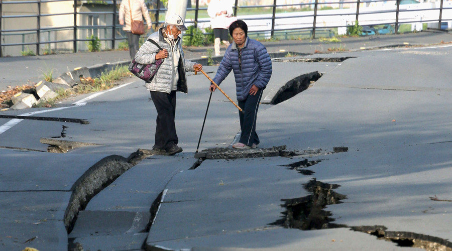
© ReutersLocal residents look at cracks caused by an earthquake on a road in Mashiki town, Kumamoto prefecture, southern Japan, in this photo taken by Kyodo April 16, 2016.
Dozens of people are feared trapped under rubble in southern Japan, as the death toll from two earthquakes has climbed to 32. The search for survivors is in full swing, while 70,000 people have been evacuated from their homes to safer locations.

Over 200 aftershocks have hit Japan following the initial Thursday tremor of 6.5-magnitude, which hit the city of Kumamoto on the island of Kyushu. Officials have warned that the risk of further strong aftershocks will linger for about a week.

About 190 of the injured are in serious condition, the Japanese government said.

Only 24 hours later the same areas was struck by a violent 7.1-magnitude earthquake. The Japan Meteorological Agency briefly issued tsunami warnings for the areas that were still recovering from Thursday's devastating tremors.

At least nine people were killed and more than 850 injured in the first quake. The death toll in the second has risen to 29. All in all, 1,500 people have been injured in the quakes, 80 of them seriously, Chief Cabinet Secretary Yoshihide Suga said. He added that about 70,000 have left their homes.


Bizarro Earth

Mount Aso volcano erupts after deadly earthquakes in Japan

Mount Aso
© Associated Press
After a series of deadly earthquakes in Japan, a "small-scale" eruption of Mount Aso has been recorded by the Japan Meteorological Agency. However, it decided to keep the alert level at 2, as it was not immediately clear whether the natural disasters were related.

Plumes of smoke rose some 100 meters into the sky, according to local media and videos captured by witnesses. The eruption of Mt. Aso, located in southern Japan, was recorded at around 11:30pm GMT Friday.


Alarm Clock

New powerful 7.1 magnitude earthquake strikes near Japan's Kumamoto, tsunami warnings issued

7.1 magnitude Japan quake map
© earthquake.usgs.gov
A magnitude-7.1 earthquake has hit Japan near the city of Kumamoto on the island of Kyushu, the Japan Meteorological Agency reported. Tsunami warnings have been issued.

The epicenter of the quake in southern Japan was located at a shallow depth of 10 kilometers, near the area where a 6.5 earthquake struck on Thursday.

According to the US Geological Survey, the quake had a magnitude of 7.0 and its epicenter was located just 1 km southwest of the city of Kumamoto.

An aftershock of 5.8 magnitude has also been reported in the area.

"Tsunami warnings or advisories are currently in effect," Japan Meteorological Agency said.

The tsunami advisory has been issued for the Ariake and Yatsushiro Seas.

The advisory warns of a possible wave of one meter in height, Japan's NHK broadcaster said.


Comment: See also:


Attention

6.2 magnitude earthquake strikes off coast of Guatemala

Guatemala earthquake
© USGS
A magnitude-6.2 earthquake has struck an area off the Pacific coast of Guatemala.

There are no immediate reports of damages or injuries.

The U.S. Geological Survey says the quake occurred Friday just after 8 a.m. local time (1400 GMT).

It was centered about 135 miles (219 kilometers) southwest of Guatemala City.

The head of Mexico's civil defense agency says the quake was also felt lightly in the state of Chiapas, which borders Guatemala.

Attention

Japan earthquake update: Tens of thousands flee in fear of aftershocks and volcanoes

Japan earthquake April 2016
© REUTERS/KyodoA collapsed house is seen after an earthquake in Kumamoto, southern Japan

At least 44,000 people evacuated following 6.4-magnitude quake that killed at least nine


Tens of thousands of people have been evacuated from earthquake-hit southern Japan as dozens of aftershocks struck and officials monitored nearby volcanoes for signs of activity.

A total of 44,000 people were evacuated late on Thursday in the town of Mashiki after a magnitude-6.4 earthquake collapsed buildings and damaged other infrastructure. Nine people have been confirmed dead, ranging in age from 29 to 94. A further eight are in serious condition, and more than 850 were injured.

The Japan Meteorological Agency (JMA) has warned there are likely to be strong aftershocks for the next week and advised people to stay away from any buildings that look unstable.

There are also concerns about volcanic activity in the wake of the quake. The island of Kyushu, where the earthquake happened, is a highly volcanic area. A level 2 warning - meaning people should not approach a volcano's crater - has been in place for Asosan in Kumamoto prefecture on the island since November 2015.


Arrow Up

Magnitude 6.5 earthquake strikes off Vanuatu Islands; FIFTH + 6.0 quake in recent days

Vanuatu earthquake
© USGS
The earthquake, which struck at 8:50 a.m. local time on Friday, was centered about 101 kilometers (62.8 miles) northwest of Port-Olry, or 147 kilometers (91 mi) northwest of Luganville. It struck at a shallow depth of just 10 kilometers (6.2 miles).

The United States Geological Survey (USGS) measured Friday's earthquake at a preliminary 6.5 and estimated that some 183,000 people on nearby islands may have felt the shaking, including some 2,000 people who may have experienced "moderate" to "strong" shaking.

There were no immediate reports of damage or casualties from the earthquake, though shaking would have been felt across much of the nearby islands. No tsunami warnings were issued as earthquakes below magnitude 7.5 do not tend to generate tsunamis.

Vanuatu is on the so-called 'Pacific Ring of Fire', an arc of fault lines circling the Pacific Basin that is prone to frequent and large earthquakes. On average, the island nation and the surrounding waters are struck by about three powerful earthquakes every year. Volcanic eruptions also occur frequently in the region.

In August 2011, two powerful earthquakes measuring 7.1 and 7.4 on the Richter scale struck about 63 kilometers (39 miles) south-southwest of Port-Vila. Tsunami waves of up to 1.05 meter (3.4 feet) were observed on the island of Efate, but there were no reports of damage.

Comment: This latest quake is the FIFTH + 6.0 magnitude earthquake to have struck this region in the past several days. See also: All around the world seismic and volcanic activity appears to have increased recently.