Earthquakes
S


Seismograph

Earthquakes in strange places: Shallow magnitute 5.1 shakes the second largest meteorite crater in the world in Western Australia

map earthquake
An earthquake initially measuring greater than magnitude 5 on the Richter scale has been recorded near the famous Wolfe Creek Crater in Western Australia - the second largest meteorite crater in the world.

According to GeoScience Australia, the quake struck in the extremely remote area of the vast state near Sturt Creek, close to Northern Territory border, around 12.21pm AWST (2.21pm AEST). Preliminary information has the tremor measuring in at a strong magnitude 5.1.

This, however, is likely to be either downgraded or upgraded once all data has been analysed. GeoScience Australia estimates that the quake could have felt by people up to 187km away and could have caused damage within a 15km radius.

Seismograph

Scottish Highlands are rocked by their biggest earthquake for 30 years

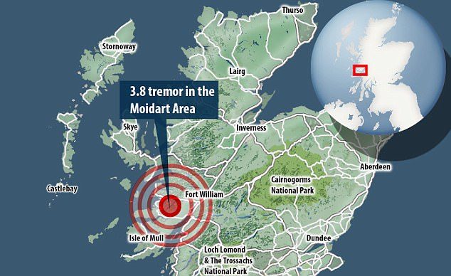
The British Geological Survey (BGS) recorded the magnitude 3.8 tremor in the Moidart area just before 3.45pm
The Scottish Highlands experienced the largest earthquake in three decades yesterday, experts have confirmed.

The British Geological Survey (BGS) recorded the magnitude 3.8 tremor in the Moidart area just before 3.45pm.

It was the biggest earthquake in the region since a magnitude 4.1 quake near Oban in September 1986, officials noted.

On the latest event, the BGS stated: 'This earthquake was felt widely across the west of Scotland.'


People in the area shared their experience of the rumble on Twitter.

One wrote: 'Think I just experienced a minor earthquake, here on Ardnamurchan. West coast of Scotland. Anyone else feel it, my kitchen rumbled.'

Seismograph

Philippines: 5.8 earthquake strikes Mindanao

Seismograph
© AP Photo/

A powerful 5.8 magnitude earthquake has struck the southern Philippine island of Mindanao, the US Geological Survey reports.

The quake, measuring 5.8 on the Richter scale according to the USGS' preliminary information, struck at a depth of 74.4 km several kilometers east of the city of General Santos, which has a population of over 600,000.

The earth tremors were reported at 8:30am (0030 GMT), the USGS said.

According to the European-Mediterranean Seismological Centre (EMSC), the quake was widely felt across the surrounding region.

Seismograph

Shallow 5.1 magnitude earthquake registered in Tonga region

chart
A 5.1 magnitude earthquake occurred in the Tonga region this morning.

The moderate earthquake occurred at 11.43am at a 10km depth.

It was located at 248km Northeast from Nuku'alofa in Tonga, 346km Southwest from Alofi in Niue, and 921km Southeast of Suva, Fiji.

The Seismology Unit of the Mineral Resources department has assured that this earthquake did not pose any immediate threat to the Fiji region.

Meanwhile, the unit also recorded two seismic activities in the Tonga region yesterday which did not pose any threat as well to the Fiji region.

Info

New images from Alaska's seafloor suggest high tsunami danger

Scientists mapping the seafloor off the coast of Alaska have identified a segment of the subduction zone they say signals the potential for a major tsunami in an area that normally would be considered benign.
Japan's tsunami
© KyodoAfter-effects of Japan's tsunami.
Major tsunamis usually occur at the shallow portions of subduction zones, the areas where one of the tectonic plates that make up Earth's surface dives below another. Called crash zones, they are dangerously active and tectonic interactions can cause some of the world's biggest earthquakes and tsunamis.

The research, led by seismologist Anne Bécel of Columbia University's Lamont-Doherty Earth Observatory, shows that segments of subduction zones capable of producing tsunamis have three characteristic structural configurations and the mapping and study of the subduction zone off the Alaska coast "suggests this part of Alaska is particularly prone to tsunami generation."

"The possibility that such features are widespread is of global significance." In addition to Alaska, she said, "waves could hit more southerly North American coasts, Hawaii and other parts of the Pacific." Bécel noted that when the energy at the point of subduction is high and suddenly is released, the resulting earthquake can make the ocean floor jump up and down like a spring. The motion then transfers to the overlying water, creating the tidal wave.

Bizarro Earth

Animated map shows every earthquake for 15 years

earthquakes
© NOAACompilation of every earthquake around the world
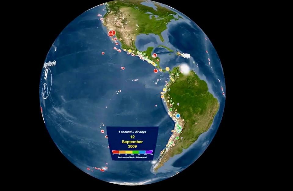
The National Ocean and Atmospheric Administration (NOAA) released an animation last year that displays every recorded earthquake between January 1, 2001, and December 31, 2015. Despite the fact that this video was released several months ago, it's a remarkable way to visualize Earth's plate boundaries and the dynamic changes in Earth's crust.

Can you pick out the Pacific Ring of Fire, the Mid-Atlantic Ridge, the collision of India with Eurasia, the building of the Andes? So much information is packed into one animation it's worth discussing what earthquakes tell us about global plate tectonics and mountain building.

The video is both color coded by earthquake depth and sized dependent on the magnitude. Hotter colors represent shallower earthquakes whereas cooler colors represent deeper earthquakes up to 800 km. The circles are sized based on magnitude but then shrink as to not obscure subsequent earthquakes. At the end of the video, there is a compilation of every earthquake in that 15-year time frame, earthquakes with magnitude larger than 6.5 and those with a magnitude larger than 8.
Seismograph

Shallow 5.3 magnitude earthquake strikes off Crete

Crete earthquake
A magnitude 5.3 earthquake jolted the Greek island of Gavdos, south of Crete, in the early hours of Tuesday, according to the United States Geological Survey.

The USGS said the quake struck at 00.29 a.m. (UTC) and was at a depth of 16.6 km.

Experts said they do not expect any serious damage from the earthquake as the epicenter is too far from the southern coast of Crete.

Crete is a popular island resort usually packed with tourists.

In July, a magnitude 6.7 quake shook beach resorts in Greece and Turkey, killing two tourists who were crushed when a building collapsed on a bar on the Greek island of Kos and injuring nearly 500 others across the Aegean Sea region

Seismograph

Shallow magnitude 4.2 earthquake recorded in Hawaiian Islands channel

chart
The U.S. Geological Survey says a magnitude-4.2 earthquake was recorded in a channel between the islands of Hawaii and Maui.

The agency said the quake was recorded at 2:01 local time Sunday about 16 miles (26 kilometers) southeast of Kaupo, Maui, at a depth of 11 miles (17 kilometers).

Some areas experienced shaking but there were no immediate reports of damage or injuries.

The agency says the earthquake was likely due to bending of the oceanic plate from the weight of the island and posed no significant hazard.

The Pacific Tsunami Warning Center reported that no tsunami was generated by the earthquake, which also had no apparent effect on the ongoing eruption of the Kilauea volcano.

Source: AP

Seismograph

Uncommon shallow 5.3 earthquake rocks parts of southwestern Uganda

chart
The U.S. Geological Survey says an earthquake with a magnitude of 5.3 has hit southwestern Uganda.

It said the epicenter of the earthquake early Sunday was 39 kilometers (24 miles) west of the western Ugandan town of Rubirizi. The quake, occurring at a depth of 10 kilometers (6.2 miles), was also felt in parts of northern Tanzania.

There were no immediate reports of injuries or deaths from the quake.

Earthquakes have been rare in this region but it has been experiencing some seismological activity as companies search for oil in the Lake Albert area along Uganda's border with Congo.

In September 2016, a 5.7 earthquake hit East Africa's Lake Victoria region, killing at least 11 people in Tanzania and damaging property in Uganda.

Source: AP

Attention

Yellow alert issued for Katla volcano, the most powerful on Iceland

An earthquake of the magnitude of 3 occurred at Katla just after midnight.
© Iceland Met OfficeAn earthquake of the magnitude of 3 occurred at Katla just after midnight.
Following tremors at Katla in South Iceland and a glacial river flood in Múlakvísl, the Icelandic Met Office has raised the status of the famous volcano on its 'Aviation Colour Code Map for Icelandic Volcanic Systems' from green to yellow.

An earthquake of the magnitude of 3 occurred in the Katla caldera at 00:48 last night followed by a series of smaller tremors. The seismic unrest could be connected to the glacial river flood and not connected to a possible eruption at all but the Iceland Met Office cannot be certain at this point.

Alert code yellow means that the volcano is active but that nothing points to an imminent eruption. If the colour code moves up to orange it means that the volcano is increasing its activity and an eruption is becoming likely.